Melbourne University Law Review

|
|
Home
| Databases
| WorldLII
| Search
| Feedback
Melbourne University Law Review |
|
REBECCA NELSON[*]
The ecological condition of many urban waterways in Australia is poor and declining. A key driver for the decline is excess urban stormwater runoff caused by the cumulative effects of urban developments. Inspired by insights from scientific studies of cumulative environmental effects, this article undertakes a traditional legal analysis across five areas of law to explore their potential to address this problem, and pioneers an approach to spatio-legal analysis to understand key gaps in the application of legal mechanisms to Melbourne. Although many legal mechanisms might be used to address sick city streams, and despite significant recent reforms, many lack strong goals and quantitative standards, and the strength of legal controls varies greatly across Melbourne. The Yarra Strategic Plan under the groundbreaking Yarra River Protection (Wilip-gin Birrarung murron) Act 2017 (Vic) presents an opportunity to pilot an improved approach to protecting and restoring city streams in the context of the stormwater impacts of intensifying development.
CONTENTS
Melbourne is the fastest-growing city in Australia, and one of the fastest-growing in the developed world.[1] Population growth occupies the front pages of newspapers and the work of government analysts.[2] Most focus on ensuring that growth is accompanied by adequate social infrastructure, particularly transport,[3] while relatively little popular attention has been devoted to the ways in which increasing development can degrade urban waterways. Yet vast new greenfield estates, large-scale urban renewal projects, and urban infill developments can, cumulatively, significantly affect city streams.[4]
Rivers and creeks form the arteries and veins of metropolitan areas — from large rivers like Melbourne’s Yarra River (Birrarung) to half-forgotten drains alongside urban cycle paths.[5] They are sometimes ‘the [most] significant natural areas remaining in urban landscapes’.[6] Urban waterways support important biodiversity,[7] provide physical and mental health benefits to city dwellers,[8] harbour important heritage and Indigenous and non-Indigenous culture,[9] and provide economic benefits through recreation, water supply, natural water treatment, and increased property values.[10] The cumulative impacts of development can threaten the capacity of city streams to provide these benefits.
Excess stormwater runoff, which is increased by development, is the ‘fundamental driver’ of most of the changes that degrade natural waterways in urbanising areas.[11] Future urban growth and more frequent extreme weather events triggered by climate change will likely increase stormwater and stream degradation.[12] City streams will become even sicker. Increased stormwater runoff is also expected to cause economic losses through increased flash flooding and significant new costs of upgrading drainage infrastructure.[13]
This phenomenon has attracted the recent attention of the Australian Senate[14] and state governments.[15] It lies within local governments’ core legislative obligations to consider the cumulative effects of their decisions on the environment.[16] Nonetheless, no sustained scholarly work has analysed the full range of relevant current regulation in this area. Such an investigation is made particularly timely by the passage of the groundbreaking Yarra River Protection (Wilip-gin Birrarung murron) Act 2017 (Vic) (‘Yarra Act’), which provides scope to implement new and more effective regulatory responses to the cumulative environmental effects of urban stormwater flows.
Using the case study of metropolitan Melbourne, this article explores the complex, layered laws that could and likely should be used to address the cumulative effects of increased stormwater on city streams. It demonstrates that a wider range of legal mechanisms could be used to address excess stormwater runoff than is commonly appreciated, though a brief traditional legal and qualitative analysis suggests important weaknesses in the range of existing legal mechanisms and the ways in which they are presently used. A quantitative spatio-legal analysis that uses maps to display and analyse law — the first time the approach has been used in a major Australian law journal[17] — reveals important gaps in the use of these mechanisms. These gaps leave waterways ecologically vulnerable and invite future economic losses from flooding. Its findings point to opportunities for new approaches using mechanisms under the Yarra Act to better link the longstanding silos[18] of land use and water management and address key weaknesses in current legal approaches. Its findings also speak to current efforts to reform stormwater-related laws in Victoria,[19] across Australia,[20] and internationally.[21]
More broadly, the study addresses a critical problem in environmental and natural resources law — the ways in which law can better address cumulative environmental effects (‘CEEs’). CEEs are the significant aggregate effects of many actions, including spatially and temporally dispersed actions that may be individually minor.[22] CEEs range from climate change,[23] to biodiversity losses caused by clearing land,[24] to the biological accumulation of toxic pollutants.[25] Indeed, leading scientists have suggested ‘planetary boundaries’ that demonstrate a ‘safe operating space’ for aggregate human effects on the environment, beyond which there is a high risk of serious impacts on earth-system functions.[26] Around the world, legal responses to CEEs are considered grossly inadequate, requiring improvements in law, policy and associated guidance.[27] This case study brings a broad legal analysis into dialogue with the scientific literature on CEEs. Alongside the Melbourne case study, this dialogue produces generalised principles for examining legal mechanisms to address CEEs that share the particularly thorny characteristics of the environmental effects of urban development on waterways — namely, widespread and dispersed effects from numerous sources, a low threshold for significant environmental effects, and significant existing effects from historical activities.
Part II of this article sets out background information helpful for identifying, analysing and selecting legal mechanisms for protecting (preventing harm from runoff) and restoring (remediating existing harm from runoff) city streams, understood broadly as including major and minor waterways that appear ‘natural’, as well as highly modified watercourses such as open drainage channels.[28] First, it briefly outlines the scientific basis for development adversely affecting urban waterways. It then outlines how these effects can be characterised as CEEs, and summarises regulatory challenges related to addressing CEEs, leading to generalised principles for investigating relevant legal mechanisms. Finally, it outlines how spatial analysis can help, and briefly describes the spatio-legal methods pioneered in this article. Part III explores the broad concepts, values and goals that the law adopts for waterways, which take shape through legal definitions of waterways and processes for setting broad visions and detailed targets for them. These are the figurative legal destinations to which legal mechanisms to protect and restore the health of waterways advance. Part IV uses the lens of CEEs to examine these specific legal mechanisms relevant to the health of urban waterways in the context of stormwater flows. These mechanisms span a broad range of laws, here categorised for convenience into five areas: public (Crown) land law, including that related to protected areas; planning laws; building laws; environmental laws; and water laws. In relation to each area, the article first explores the current and potential future operation of relevant mechanisms doctrinally and qualitatively, by reference to specific instances of their use. Part V then examines, using a quantitative and spatial approach, the extent to which these mechanisms protect Melbourne’s city streams, and the locations of ‘hotspots’ that are comparatively legally vulnerable to producing increased stormwater flows, and therefore adverse CEEs. Part VI concludes by summarising key opportunities for enhancing and extending the legal mechanisms reviewed to protect and restore sick city streams, both across metropolitan Melbourne in general and also in the context of the Yarra Act. Finally, Part VII concludes, reflecting on larger lessons for considering legal mechanisms to address CEEs.
Compared to ‘natural’ streams, city streams have modified flow regimes, reduced water quality, physical changes, reduced or absent riparian vegetation, and reduced in-stream flora and fauna: they are sick, afflicted by ‘urban stream syndrome’.[29] Science and government policy recognise that a key driver for these changes is increased stormwater runoff from impervious urban surfaces, such as roofs, carparks and roads,[30] which is piped directly to streams, and which traditional stormwater management arrangements have addressed poorly.[31] Urban growth increases impervious surfaces, which are expected to rise to almost 90% in some urban Australian municipalities.[32] Modelling suggests that impervious surfaces in Melbourne in 2051 will be 43% greater than in 2011 due to population growth.[33] A useful metric describing this phenomenon is ‘directly connected imperviousness’ (‘DCI’).[34] Conventional drainage systems rapidly convey runoff from these surfaces through pipes directly to streams, rather than slowly through natural infiltration processes.[35] This increases pollution, changes flow rates, waterway structures and features, and ultimately changes stream habitat, biodiversity and associated ecological processes, such as nutrient cycling and connections between channels and floodplains.[36] Even low DCI levels of 1–5% of the catchment surface can alter the hydrology of receiving streams, resulting in the loss of many in-stream species.[37] As well as affecting streams directly, excess runoff can also discourage or inhibit waterway restoration.[38] Large peak flows can prevent effective revegetation[39] and have encouraged drainage managers to line waterways with concrete — at great cost and with drastic ecological consequences.[40] Fears about flooding and insufficient information about the ecological benefits of reducing high flows[41] can prevent efforts to restore existing channelised waterways.
Several approaches are used to prevent and treat ‘urban stream syndrome’. One approach is to build infrastructure (known as stormwater control measures (‘SCMs’)) to capture stormwater before it reaches urban waterways.[42] This ‘disconnects’ impervious surfaces from streams, reducing DCI.[43] The goal is to maintain or return the water balance to a pre-development or lesser-developed state.[44] SCMs, like rainwater tanks and raingardens,[45] can be used at the land parcel scale, near the source of the stormwater; larger SCMs, like constructed wetlands and other forms of detention basins, swales and infiltration trenches,[46] can be used at the neighbourhood scale. Another approach is to control the construction of impervious surfaces, either by constraining development or by constructing surfaces that allow infiltration, such as pervious driveways and carparks.[47] These measures focus on hydrologic processes and have implicit water quality benefits.[48] Another measure is to increase the direct use of stormwater (for example, to irrigate green spaces), though this is considered a desirable adjunct to SCMs, rather than sufficient in itself,[49] and is not discussed further here.
To date, investments in protecting city streams have been ad hoc and opportunistic, through a combination of large-scale ‘end-of-pipe’ stormwater retention systems and household-scale infrastructure incentives.[50] Significant public investment (over $120 million in Victoria[51] and at least twice this amount for federally funded projects[52]) has not yet notably improved waterway health.[53] This warrants investigating the potential for a more comprehensive response, based in law or policy, to prevent and treat sick city streams. Accordingly, this regulatory investigation focuses on both preventative and remedial legal mechanisms that may be used to control the development of DCI and build SCMs to protect and allow the restoration of urban streams.
This article applies a novel theoretical and methodological lens to analysing potential legal responses to sick city streams, inspired by the cumulative nature of the environmental problem, and spatial methods more common in scientific literature.
The adverse ecological effect of urban stormwater flows is a CEE.[54] Recognising this characteristic activates principles for regulating these effects that guide an investigation of laws used to respond to CEEs. These principles help address the questions: what can the law do to protect and treat sick city streams, as an example of cumulative environmental harm; which laws can do these things; and what should they consider? Because diverse, individually minor activities may collectively have significant impacts, a regulatory response to CEEs should consider (if not control) all sources of adverse impact, regardless of their type, frequency or individual magnitude (noting that regulating numerous and diverse activities involves challenges well known in the commentary relating to ‘diffuse’ sources of water pollution).[55] For example, a large tourist carpark on Crown land, a large private residential development’s carpark, and a small residential carpark all have potential to generate stormwater CEEs. A key point of analysis is therefore the degree to which an activity is included or excluded from regulatory controls because it has a different nature, occurs on different land tenure, or has a different magnitude of effect. Legal inquiries must traverse complex urban regulatory landscapes, since a huge array of legal mechanisms and regulatory institutions control diverse relevant activities.
Environmental science shows that numerous minor effects may combine in complex ways, with important regulatory implications. First, they may aggregate to create an ecological ‘tipping point’, beyond which harm increases non-linearly.[56] That is, rather than simply adding together (eg A+B), they may accumulate synergistically (eg A*B) beyond a certain point.[57] In the case of stormwater flows, important ecological thresholds arise even where DCI percentages (in terms of catchment coverage) are very low.[58] A regulatory response to CEEs should therefore consider (if not control) potential adverse effects even at relatively low aggregate levels of development, and recognise that highly developed urban catchments may have long ago exceeded thresholds of significant ecological harm. Legal interventions should, accordingly, be based on clearly specified desired levels of ecological health (ie goals) that can, in turn, influence how proposed developments are considered. High levels of existing ecological degradation also raise legal, equitable and political issues about whether existing developments should attract new regulatory controls — or perhaps non-mandatory measures, such as incentives — to address their ongoing effects.
Ecological effects can be adverse (as described above), accumulating in harmful ways, or beneficial.[59] A beneficial effect may counteract an adverse effect to some degree (eg A–B).[60] Accordingly, if an effect cannot be reduced sufficiently in absolute terms, beneficial action undertaken elsewhere may mitigate or ‘offset’ harms to reduce net adverse ecological effects.[61] In the stormwater context, a landholder with insufficient space to install an SCM to ‘disconnect’ unavoidable impervious surfaces could pay a different landholder with more space to install an SCM to reduce the rapid discharge of stormwater to an urban stream. Laws may encourage or require SCMs, or perhaps remove barriers to them, to facilitate mitigating the adverse stormwater effects of one or multiple past or present developments.
The CEE literature adopts a binary categorisation of tools for addressing CEEs as ‘regional’ or ‘project level’,[62] which is useful to adopt here. Much of the environmental literature and practitioner experience focuses on how CEEs are considered in project-level environmental impact assessment.[63] This type of assessment involves identifying the possible environmental risks of a proposed project — ideally including an analysis of its cumulative effects in the context of other past, present and reasonably foreseeable future projects[64] — to inform decisions about whether the proposal should proceed, and under what conditions.[65] Although individually minor developments (such as stormwater effects of a single development) fall below regulatory thresholds of a significant environmental effect that triggers a requirement to undertake an environmental impact assessment,[66] the concept of considering CEEs at the level of an individual development is relevant to other regulatory approval processes, such as those that apply to the grant of a planning permit. CEEs can also be assessed and controlled at the regional[67] or watershed[68] scale, with the focus of the literature being regional ‘strategic environmental assessments’ under environmental laws, which are ideally linked to project-level assessments.[69] Though these strategic assessments are sometimes applied to urban development, they have apparently overlooked the environmental effects of increased stormwater flows.[70] However, the concept of strategically influencing multiple developments across a region is also relevant outside environmental impact assessment laws as a way to control CEEs.
This article adopts the binary categorisation of project- and regional-level tools in the following way: regional mechanisms apply across more than one landholding to all or certain types of developments within a geographically defined area (for example, a catchment or a local government area (‘LGA’)). They may set environmental goals and management strategies, or determine the kinds of development that must be assessed and approved at the project level. Project-level mechanisms apply to single developments or landholdings. They may determine whether and how a project may go ahead (analogous to environmental impact assessment) or continue (in the case of an existing activity), or how a landholding is to be managed.
In summary, adopting scientific understanding and reasoning about CEEs in the legal domain reveals the following generalised principles for examining legal mechanisms to address CEEs that involve similar characteristics to those of excess urban stormwater flows. An examination should involve investigating a wide range of legal mechanisms that: (a) operate at the regional or project levels, and consider links between levels, to (b) comprehensively consider numerous diverse ecologically relevant effects, regardless of whether they are individually significant, and (c) consider effects at low levels of overall development, recognising the potential for significant ecological harms at these low levels or at particular thresholds; (d) provide for ecologically positive interventions, including removing barriers to beneficial action; and (e) use clear goals and baselines, recognising existing effects and providing for regulatory mandates or incentives, as appropriate. Part IV applies these principles to investigate legal mechanisms that operate in metropolitan Melbourne to protect urban waterways by controlling development that would create impervious surfaces and facilitating construction of SCMs. While this analysis is restricted to legal mechanisms as they appear on paper, by identifying specific mechanisms it opens the way for empirical research on their implementation.
Our legal system often divides resources among silos — water and land, public and private — drawing legal distinctions that are unrelated to environmental effects.[71] Where diverse activities that produce CEEs span multiple silos, they can, in the aggregate, trigger a very wide range of statutes and legal mechanisms (outlined in Part IV). While some laws may apply generally, others are ‘legal norms, rights and duties related to identifiable locations’.[72] Information about these can be understood as layers of ‘spatio-legal data’.[73] Gaps in these layers may mean the relevant environmental effects are not comprehensively addressed using legal mechanisms. Using traditional legal analysis alone, it is difficult to appreciate these gaps and their significance, amid such spatially complex and layered legal controls.[74] The novel spatio-legal approach used in this article maps and analyses these layers and exposes important gaps.
Spatial analysis is a common and well-recognised scientific approach to assessing CEEs,[75] and has recently been used to evaluate the physical infrastructure aspects of stormwater management in Melbourne.[76] Spatial analysis usually involves using geographic information systems software to map proposed and existing sources of environmental stress on valued environments,[77] sometimes together with relevant social and political characteristics.[78] While the legal implications of geospatial information have attracted significant legal interest,[79] legal scholars (particularly in the environmental field) have also been urged to use spatial analysis,[80] although few have done so. Spatial analyses of environmental policies undertaken in other disciplines are generally limited in their legal depth.[81] Existing spatio-legal work in the environmental sphere has tended to use data on land ownership and administrative boundaries,[82] the distribution of statutory conservation areas like national parks and other protected areas,[83] and the spatial distribution of US water policies compared to pollution hotspots.[84]
This is not to say that law (including environmental law) and geography do not meet. On the contrary, the quarter-century-old field[85] of legal geography examines ‘the presence and absence of spatialities in legal practice and of law’s traces and effects embedded within places’.[86] However, its methods are critical and qualitative, tending not to use geographic information systems. Indeed, legal geography emphasises alternatives to traditional positivist scientific ontology, epistemology and methodology.[87] In the wider legal field, legal scholars have used geographic information systems (albeit uncommonly) in diverse ways to examine electoral districting practices,[88] education law,[89] criminology,[90] human rights,[91] and law and history.[92]
Spatial analysis of legal instruments in the environmental field — at a detailed legal level and aggregating layers of legal mechanisms — illuminates the law in ways that would otherwise not be possible. This article uses geographic information systems to demonstrate how diverse legal mechanisms that are relevant to stormwater flows apply in the spatial context of jurisdictional boundaries and the spatially diverse conditions of city streams. This spatio-legal approach reveals gaps in current legal protections, the legal actors with jurisdiction to address those gaps, and — in light of varying ecological conditions — priority areas for further action. Considering overlaps between multiple layers of planning, building, environmental, and water laws, in combination with complicated systems of land tenure and policy-based initiatives, also reveals elements that would benefit from coordination. In particular, hydrological connections mean that improving the ecological condition of a downstream reach of an urban waterway requires stormwater controls to be applied by multiple upstream jurisdictions, potentially using legal mechanisms spanning multiple legal ‘layer[s]’ in order to comprehensively control multiple development types.[93]
Melbourne’s city streams are ecologically sick.[94] On recent data, 56% of the stream length in the six basins over which metropolitan Melbourne extends is in poor or very poor condition[95] (generally measured relative to its pre-European state[96]). Only 5% is in good condition, and only 0.07% is in excellent condition.[97] This sobering data (reflecting stormwater effects of existing DCI) invite an exploration of how law and policy conceive of urban waterways in space and in terms of their values, how law sets ecological goals for these waterways (to which stormwater-related controls should be directed), and how powerfully legal mechanisms are connected to these goals. Recent and emerging changes hold promise for clearer, more quantitative ecological goals with stronger legal weight to guide improved legal responses to these CEEs.
Historically, Australian laws conceived of rivers narrowly as permanent streams, flowing in defined banks, which had value for agriculture and transport.[98] They did not typically encompass intermittent and ephemeral streams[99] or recognise or protect ecological values.[100] By contrast, the conception of waterways in current Victorian law extends to heavily modified waterways[101] and seeks to protect their ecological values.[102] For around two decades, catchment and water laws have provided for statutory water strategies (regional catchment strategies and regional waterway strategies)[103] that encompass ecological values, natural and modified waterways, and connections between water, waterways and floodplain land in general.[104] The strategies have arguably struggled to protect the ecological health of urban waterways for reasons that include their status as mere ‘considerations’ for public land managers,[105] and the fact that their function of setting goals and values for catchments and water ecosystems[106] has sometimes been undertaken in ways that are inconsistent and non-transparent.[107] Allied statutory[108] and non-statutory water-related strategies usefully highlight connections between land use and water, but adopt relatively vague goals such as ‘[h]ealthy and valued waterways and waterbodies’.[109]
A new 50-year regional waterway strategy (‘Healthy Waterways Strategy’) for Melbourne, finalised in November 2018, decisively clarifies ecological goals, particularly in relation to stormwater. While it adopts broad ‘key values’,[110] it also sets supporting ‘waterway conditions’, including ‘[s]tormwater condition[s]’,[111] maps ‘[p]riority areas for enhanced stormwater management’,[112] and sets measurable long-term ‘[w]aterway condition targets’ and short-term ‘performance objectives’.[113] Stormwater conditions and objectives are quantified based on current and targeted DCI.[114] Meeting important CEE principles,[115] these provisions recognise existing degradation as well as low, scientifically supported thresholds of ecological harm (<0.5% DCI being required for ‘Very High’ conditions indicating ‘minimal or no threat from stormwater’, to >10% for ‘Very Low’ conditions indicating severe impacts on stream health).[116] Quantifying the desired degree of change in stormwater conditions is vital to allow decision-makers to assess an appropriate combination of legal mechanisms[117] for achieving them. Quantified goals also remove discretion that can make decision-makers vulnerable to the inappropriate influence of powerful interest groups.[118] The challenge remains ensuring that these goals have strong legal connections to the legal mechanisms that can achieve them, to avoid ineffective or ad hoc use of these mechanisms.
The Yarra Act presents significant promise for connecting stormwater goals with legal mechanisms. It also significantly expands Victoria’s statutory conceptualisation of the values of waterways — though its relatively narrow spatial conceptualisation of the river (relative to regional catchment strategies) may pose problems. Uniquely among Victorian legislation, the Act seeks to protect the river as ‘one living and integrated natural entity’,[119] informed by traditional Wurundjeri views. Its ‘Yarra protection principles’ broadly embrace ecological values (biodiversity, ecological integrity) and wide-ranging social and cultural values[120] (although they use very broad qualitative language[121] and lack a clear hierarchy,[122] unlike some broadly analogous water statutes).[123] A statutory ‘long-term community vision’[124] details these values for four river reaches,[125] using similarly broad language.[126] More specific environmental target-setting in relation to Yarra River land[127] is the job of ‘performance objectives’ in a ‘Yarra Strategic Plan’ (‘YSP’), discussed in Part VI, a draft of which was released in January 2020.[128] The new Healthy Waterways Strategy provides a clear set of quantitative stormwater-related goals that the YSP could usefully adopt. Conversely, the YSP provides a legally binding framework to translate these goals into regional- and project-level mechanisms for achieving them.[129]
The YSP’s impact on stormwater will be influenced by its spatial limits. Two key spatial delineations are associated with the Yarra River: first and foremost, ‘Yarra River land’,[130] and second, ‘[l]and to which [the] Yarra Strategic Plan [applies]’.[131] ‘Yarra River land’ refers to a declared area of public land adjacent to the Yarra River, or any part of which is within 500 metres of one of its banks.[132] The YSP will apply to this area and a larger, as yet undeclared area that includes public and private land within one kilometre of the riverbank and potentially land in the adjacent municipalities.[133] However, since the potential YSP area does not cover all of the Yarra catchment,[134] outer catchment developments excluded from its potential stormwater controls may compromise its ecological goals.
The parlous state of Melbourne’s waterways raises the question: do we lack laws to address the ecological health of city streams?[135] If not, are existing laws fundamentally flawed? Or unused? This part begins to answer the first two of these questions in light of the general principles informed by CEE concepts set out in Part II(B)(1). It examines key state and local[136] legal mechanisms that operate at both the project and regional level to protect urban waterways by controlling development that would create impervious surfaces (regardless of whether this protection is sought intentionally or is an incidental effect of the mechanism), and restoring urban waterways through SCM construction (ie both preventing adverse effects in absolute terms and providing for positive interventions and mitigating adverse effects). It also examines legal mechanisms for indirectly controlling CEEs by managing Crown land and incentivising desirable land management practices.[137] This examination discusses the strengths and weaknesses of each mechanism based on a qualitative examination of the statutory framework for, and examples of, each mechanism, having regard to CEE concepts. It identifies ways to address weaknesses through improving either the overarching statutory frameworks, or the individual legal instruments within these frameworks that apply to particular areas. The analysis extends recent consultations relating to stormwater reforms undertaken by environmental advocates and government[138] and Victoria’s late-2018 stormwater planning reforms,[139] and builds on existing work focusing on several legal aspects of water quality and water quantity impacts of stormwater.[140] Part V then uses a spatial analysis to understand the extent to which key regional mechanisms apply in metropolitan Melbourne.
Crown ownership of land provides a regional-level approach[141] to restricting the development of impermeable surfaces, constraining additional stormwater flows. This effect is incidental rather than intentional: statute restricts development in public protected areas.[142] Even on other forms of Crown land, development seems less likely to occur at a large, profit-motivated scale than on private land. Management of Crown land by a relatively small group of public entities is more easily guided and influenced than that of numerous private landowners. Though developments on Crown land are often excluded from planning law-based stormwater controls (discussed below), Crown land provides unique scope for ecologically positive interventions — constructing SCMs to mitigate the effects of existing or future developments — through direct government action and incentive-based measures. This opportunity arises particularly because historically, riparian land was reserved so that it could not be privately owned.[143]
At one end of the Crown land spectrum lie urban[144] and remote public[145] protected areas, managed under conservation-oriented legislative schemes. These do not explicitly seek to prevent ‘urban stream syndrome’, but do so incidentally through development controls, to varying degrees. ‘[R]eference areas’ and certain zones of national parks and state parks are to be preserved in their ‘natural state as far as is possible’ or for water supply purposes.[146] Some development is permitted in other areas. Leased areas of national parks and state parks may host tourism-related buildings, but are obliged to protect water resources.[147] In heritage river areas, few activities are prohibited — typically waterway diversions and timber harvesting[148] — with no prohibition on the construction of hard surfaces.[149] However, protected areas with looser controls on development could potentially host SCMs where consistent with their statutory conservation objectives.
‘Reserved’ Crown land is dedicated to a specific public purpose.[150] It may not be sold, leased or licensed for other purposes.[151] Its purpose may be explicitly to protect waterways[152] or a conservation-related purpose that inherently controls development.[153] Some purposes explicitly contemplate roads, carparks, or buildings, from preschools to prisons.[154] Unfortunately, public roads and carparks can contribute as many impermeable surfaces as privately owned land,[155] and public development may even counteract private efforts to address adverse damaging stormwater flows.[156] However, regulations for reserved Crown land offer opportunities to protect and manage Crown reserves and regulate activities on them[157] (though no environment-focused regulations currently exist).[158] Crown reserve management agreements between the State and a land manager[159] also have this potential. In both cases, a requirement to implement best practice stormwater management would mirror requirements of lessees of unreserved Crown land (see below). Policy guidance to managers could encourage installing SCMs (with costs potentially offset by beneficiaries),[160] much as ‘Statement[s] of Obligations’ impose positive environmental obligations on water authorities.[161] The Yarra Act imposes new obligations on public land managers to not act inconsistently with (and have regard to) the YSP,[162] which may include stormwater components.[163]
Examining all types of ‘unreserved’ Crown land is beyond the scope of this article. However, three potential vehicles for protecting urban waterways are particularly notable. First, ‘[t]o manage leased Crown land in an ecologically sustainable manner’,[164] Crown leasing policy requires proponents to ‘implement best-practice stormwater management’.[165] Defining this currently undefined phrase using quantitative standards used in planning laws[166] may address concerns that governments manage public land with less environmental rigour than is required on private land.[167] Second, incentive-based ‘riparian management licen[sing]’ arrangements over unreserved Crown water frontages grant reduced rental fees to licensees in exchange for management practices such as fencing out stock,[168] which benefit water quality. This fee reduction incentive could be extended to leasing Crown land more generally, where SCMs are used or where land management practices provide a net stormwater benefit. Finally, the Crown could use its power to vary or cancel licences in the public interest[169] to construct SCMs such as large detention basins[170] to counter the effects of existing or future development. This would avoid problems of politics and equity that arise if requirements for parcel-scale SCMs were imposed retrospectively on private landowners.
Finally, Commonwealth land includes significant DCI in airports on near-stream land in western Melbourne, and may create future DCI through ‘urban renewal’ on its land.[171] This presents a risk to waterway health, since state environmental laws (which deal primarily with water quality) apply to it,[172] but planning laws (which currently provide the most significant protections for urban waterways from stormwater flows) do not.[173] Some management arrangements for significant Commonwealth land close to Melbourne rivers incorporate relatively well-established SCMs (notably the Essendon Airport redevelopment),[174] while in other cases, management arrangements are more recent and still evolving (notably Melbourne Airport).[175]
In sum, Crown land presents significant regional-scale protection from stormwater CEEs through development constraints on public protected land, and opportunities for addressing CEEs through regulations or policy guidance for Crown reserves, and leasing and licensing policy guidance for unreserved Crown land. Unreserved Crown land, and Crown reserves with environment-related purposes, offer promise for strategically constructing SCMs, whereas Commonwealth land presents an ongoing legal dilemma that is perhaps best addressed through negotiation between governments in respect of large developments.
Planning laws, which control how land may be used and developed, provide clear vehicles for controlling the impacts of new (but not existing)[176] public and private[177] urban developments on waterways. Recent Victorian stormwater policy reform, which aims to ecologically revive sick city streams,[178] has focused on planning laws,[179] most recently through statewide statutory stormwater policies introduced in October 2018 (‘Amendment VC154’).[180]
The central regional-level planning law mechanism is a ‘planning scheme’, usually made by a municipal council to guide land use and development in its municipality.[181] Planning schemes are structured around standard provisions for zones and overlays, which schedules can vary.[182] Zones prohibit certain land uses or developments or allow them with or without a planning permit.[183] Overlays apply to certain land with special characteristics, including special environmental characteristics, and may apply additional requirements to planning permit applications.[184]
Project-level planning permits regulate particular uses and developments of individual parcels of land. A decision-maker must consider regional mechanisms and generally applicable statutory objectives and considerations in determining a permit application.[185] A planning scheme may also require an application to be given to a referral authority for comment or conditions.[186] Stormwater concerns may manifest as permit conditions (analogous to ‘project-level’ assessment and management in the CEE literature), potentially after referral to a water authority, and separate agreements between local governments and landowners.
The ‘urban growth boundary’ limits development outside a rough ring around Melbourne in order to permanently protect ‘the values of non-urban land’.[187] The boundary is implemented through planning schemes that apply to the metropolitan fringe, but can only be changed through ratification by Parliament of an amendment.[188] Although it does not directly prohibit the construction of impermeable surfaces,[189] it protects urban waterways incidentally by generally prohibiting further subdivision of land and the associated increased DCI.[190]
Another relatively coarse planning control tool that incidentally protects urban waterways is land zoning for public purposes (‘public use zones’),[191] which covers certain types of public land.[192] Two of the three public use zones specifically foresee primarily open space-based (ie permeable) land uses,[193] while contemplating minor developments,[194] while the third contemplates significant development — for example, for education or local government buildings.[195] Although Amendment VC154 (discussed below) extends stormwater requirements to important public use zones,[196] its impact may be limited because, consistent with State policy, public managers need rarely obtain a development planning permit (which is required to trigger a zone’s stormwater requirements).[197] This mirrors the unevenness in stormwater requirements that exists between Crown land managers and private lessees of Crown land (discussed above).[198] Public land zoning could better protect city streams by continuing to exempt only developments that meet stormwater standards (for example, on-site runoff retention or an equivalent offset) from a permit requirement. The same approach could apply to public land in other zones, such as roads, which are often in ‘regular’ zones, yet constitute 30–70% of a catchment’s impervious surfaces.[199] Empirical evidence questioning the environmental performance of Victoria’s local governments[200] warrants increased scrutiny of public land use.
Within the urban growth boundary, greenfield (typically outer metropolitan) and urban renewal (typically inner metropolitan) areas are sites of intense development.[201] Specific planning mechanisms for these areas offer scope to improve stormwater management. Precinct structure plans manage the transition of non-urban greenfields into urban land,[202] and planning permits granted within their areas ‘must be generally in accordance with the [applicable] precinct structure plan’.[203] Urban renewal frameworks guide the redevelopment of urban renewal areas.[204] Stormwater requirements in precinct structure plans commonly require runoff to meet or exceed the performance objectives of the best practice environmental management standards for stormwater (‘BPEM’),[205] or directly set requirements that vary widely — from requiring individual dwellings to retain stormwater on-site,[206] to requiring development as a whole to ‘aim to maintain existing flow regimes ... at the pre-development level’,[207] or ‘as close as possible’ or practical thereto, either overall[208] or in conservation areas.[209] Some precinct structure plans are silent on stormwater quantity or quantity targets,[210] or describe qualitative goals of ‘ensuring waterway health’.[211] Precinct structure plans also plan the location of SCMs[212] in accordance with applicable development services schemes.[213]
By contrast, the few currently available urban renewal frameworks show relatively little detailed attention to, or aspirations for, stormwater flows. One merely notes the presence of ‘significant waterways’,[214] and notes a ‘key principle’ of ‘[e]nvironmental sustainability and integrated water management’.[215] Another adopts integrated water management as the driver for a ‘distinctive [urban] identity’, lists a variety of possible SCMs, and includes a general goal of reducing runoff, but no quantitative goals.[216]
A more recent, higher-level approach is a declaration by the Governor in Council of an area to be a distinctive area or landscape, which allows environmentally and culturally significant areas that are under threat from some form of land use change to be protected by a state-level planning policy.[217] At the time of writing, no distinctive areas had been declared in the Melbourne metropolitan region, but one declared in an adjacent rural LGA specifically sought to address the cumulative impacts of development on natural resources.[218]
Planning schemes have traditionally dealt with environment- and water-related matters in special overlays related to flood risks and land with special environmental characteristics.[219] Though their purposes often relate to waterway health[220] (and therefore for present purposes they are deemed to have a protective effect), in practice, flood overlays focus on controlling flood risks to development rather than risks to waterways posed by development.[221] They do not directly seek to address DCI as a risk to city streams.[222]
Environmental overlays, which deal with specific environmental values such as significant vegetation or risks such as erosion,[223] may incidentally protect urban waterways where they require a permit applicant to prepare reports relating to waterway health.[224] Although the standard overlay provisions at best contain only broad policy statements about protecting rivers,[225] they require a decision-maker to consider more specific stormwater policies, for example, the State Environment Protection Policy (Waters of Victoria)[226] (discussed below) and the State Planning Policy Framework.[227]
In the Yarra Ranges, an environmental overlay supported a reputedly world-first stormwater mechanism[228] aiming to ‘return the ecological function and health of the Little Stringybark Creek to a level consistent with a natural stream’.[229] An initial $3 million ‘reverse uniform price auction’ paid landowners an average of 90% of the cost of installing a ‘“stormwater disconnection” [system]’ (such as rainwater tanks and raingarden infiltration systems),[230] achieving benefits more cheaply than on public land.[231] To maintain these benefits,[232] a new Environmental Significance Overlay[233] requires any building or work that creates an impervious surface of 10 m2 or more to include an appropriately sized stormwater treatment system (eg rainwater tank, raingarden, or permeable pavement).[234] Preliminary effects of the mechanism on the waterway are positive,[235] with general acceptance by the community and planners.[236] This experience suggests similar mechanisms may be worth investigating, at least in catchments with similar hydraulic,[237] physical[238] and socio-economic[239] characteristics to Little Stringybark Creek, or otherwise considering modifications to reduce costs for householders.[240]
Some local governments have introduced specific stormwater clauses into their planning schemes’ ‘Local Planning Policy Frameworks’. The City of Melbourne has adopted a Stormwater Management (Water Sensitive Urban Design) Policy, which applies to all new buildings (including single dwellings), significant extensions to existing buildings, and commercial subdivisions.[241] It recognises the importance of reducing stormwater runoff and minimising peak flows using SCMs, including ‘infrastructure upgrades, streetscape layout changes, piping reconfigurations, storage tanks, and the use of different paving’.[242] However, its quantitative standards and technical modelling requirements apply only to water quality.[243] A qualitative goal to ‘reduce the flow of water discharged to waterways’[244] accompanies a decision guideline as to ‘[w]hether the proposal will significantly add to the stormwater discharge ... entering the drainage system’,[245] as determined using software for the purposes of a ‘Water Sensitive Urban Design Response’ that must accompany a permit application.[246]
Several other local planning policies adopt similar approaches: for example, by generally applying qualitative requirements to reduce stormwater flows, but requiring a site management plan only for steep land[247] or large sites,[248] though some require stormwater treatment measures and a written stormwater design response to all new buildings, extensions of greater than 50 m2 in floor area, and commercial subdivisions.[249] Some impose levies on new impervious areas above a threshold to offset the cost of upgrading drainage works to accommodate new stormwater flows.[250] While these local policies are positive, they create inconsistencies that are perceived by developers as confusing and inequitable[251] — a key driver for the recent stormwater planning changes discussed below.[252]
The Planning and Environment Act 1987 (Vic) (‘Planning and Environment Act’) and the State-standard Victoria Planning Provisions contain general decision guidelines that apply to planning permit applications.[253] Under Amendment VC154, a decision-maker considering a planning permit application must consider new statewide stormwater provisions ‘as appropriate’.[254] To help protect and restore catchments and water bodies, strategies include to ‘[u]ndertake measures to minimise the quantity and retard the flow of stormwater from developed areas’ and ‘preserv[e] ... floodplain or other land for wetlands and retention basins’,[255] and ‘[m]inimis[e] stormwater ... impacts’ through ‘a mix of on-site measures and developer contributions at a scale that will provide greatest net community benefit’.[256] While these broad new statements sound promising, the 20-year-old technical guidelines that support them (the BPEM)[257] have proven ineffective. The current BPEM design and implementation guidelines for SCMs are considered to ‘set far narrower and lower stormwater capture, treatment and reuse targets than is likely required to protect urban streams’.[258] More generally, the BPEM adopts a quantified flow objective of maintaining stormwater discharges at pre-urbanisation levels for a defined flood size,[259] which recent advice to the State government claims is ‘rarely applied in practice’.[260] This poor implementation is unsurprising given that the objective is drafted as a generic objective, or one that is applicable to ‘[s]trategic catchment planning’ or the design of retarding basins,[261] and therefore not clearly applicable to individual developments. Without a clear, mandatory quantitative outcome requirement, environmental stormwater objectives can be traded off against other planning objectives, and this appears to occur in the context of urban waterways.[262]
Until recently, new DCI has been managed through controlling a key contributor: residential subdivisions and apartment developments.[263] A new cl 53.18 introduced by Amendment VC154 significantly extends these requirements, aiming to protect the ecological values of urban waterways from stormwater effects.[264] Clause 53.18 applies to many types of subdivisions, most notably subdivisions in commercial, industrial and many public use zones, and applications to construct a building or carry out works over more than 50 m2.[265] Important exclusions include buildings or works associated with one dwelling on a lot, works in a road zone, house extensions in a residential zone, and applications in the Urban Growth Zone.[266] A permit applicant must submit details of an urban stormwater management system to the satisfaction of the relevant drainage authority.[267] In addition to requiring that the subdivision meet the BPEM’s performance objectives,[268] which are ambiguous as to stormwater flows (as discussed above), a system must also ‘ensure that flows downstream of the subdivision site are restricted to pre-development levels unless increased flows are approved by the relevant drainage authority and there are no detrimental downstream impacts’.[269] The analogous provisions for apartment developments refer to the BPEM objectives, though more tentatively as design elements that ‘should’ be met.[270] Both refer to developers entering agreements to offset their stormwater impacts off-site,[271] presumably where on-site capacity to manage stormwater is limited.
Although cl 53.18 laudably addresses serious and long-noted gaps in controls on industrial and commercial developments,[272] it has clear weaknesses and carries some uncertainty. It is unclear how ‘no detrimental downstream impacts’[273] will be measured and how the BPEM standard will evolve. Continued exclusions (eg single dwellings, roads, residential house extensions)[274] mirror the classic CEE problem of focusing only on individually significant activities.[275] One way to capture these uncontrolled risks would be to introduce a planning permit trigger related to the risk that developments pose to urban waterways. Such an approach would arguably comply with current policy aims to ensure permit triggers do not proliferate[276] through ‘deemed-to-satisfy’ solutions that avoid subjecting homeowners to, for example, onerous design and approval processes.[277] Introducing a new permit requirement at smaller scales and in a way that is more targeted to catchment circumstances — for example, by using a planning overlay (as in the Little Stringybark Creek example) — may be more achievable in the short term.
Section 173 of the Planning and Environment Act allows a council (either individually or jointly with another person or body) to enter into an agreement with a landowner in its municipal area.[278] The agreement may prohibit, restrict or regulate the use or development of the land, or the conditions under which it may be used or developed, including to advance objectives[279] that include protecting city streams as natural resources that maintain ‘ecological processes and genetic diversity’, and securing a pleasant recreational environment.[280]
Section 173 agreements are very common and increasing in use,[281] and may contemplate multi-million-dollar developer contributions to counter the effects of development both on- and off-site.[282] Their potential breadth provides scope for innovative approaches to protecting and restoring city streams, including controlling stormwater CEEs.[283] Section 173 agreements may relate to both the development site and also other land: for example, adjacent or proximate riparian land.[284] Common practices requiring developers to provide off-site carparking or revegetation[285] could similarly apply to requiring a developer to construct stormwater-related works along an adjacent stream.[286] The agreements benefit from strong compliance and enforcement provisions: a landowner may be required to pay a bond or give a guarantee in relation to obligations under the agreement,[287] non-compliance with which is an offence[288] that may be scrutinised by authorised persons entering the property.[289] A template agreement[290] containing ‘default’ provisions in relation to urban waterways could reduce drafting and negotiating costs and time.
In a general sense, building laws apply even more broadly than planning laws, since standards apply to all building work at the project level (regardless of whether a planning permit is required),[291] including building work by public authorities.[292] However, permeability standards for buildings are neither ambitious nor broadly applicable: they require only a minimum 20% site permeability for an allotment, and apply only to single residential and associated dwellings.[293] This permits developments that are not caught by planning requirements to increase stormwater flows very significantly, considering the low thresholds of 1–5% of catchment coverage that result in waterway degradation.[294] Further, although new single dwellings must include either a rainwater tank or solar hot water system,[295] the take-up of the former is relatively low and difficult to forecast.[296] Without more, building requirements in relation to permeability and water tanks are insufficient to maintain or improve waterway health.[297] Recent advice to government recommends future (and implicitly, longer term) changes to the Building Regulations 2018 (Vic) and plumbing controls to ensure ‘consistent stormwater requirements are applied to all development types’.[298]
Special arrangements apply to buildings owned by the Crown, and to roads. The former receive special attention via a provision for ministerial guidelines to ‘promote better building standards’.[299] On the other hand, road authorities — for example, VicRoads, a municipal council, or a statutory corporation[300] — determine the standards to which they design and construct roads.[301] National guidelines adopted by VicRoads deal with stormwater issues in a predominantly qualitative way, and with an overriding emphasis on water quality rather than robust quantitative standards for reducing conventionally drained stormwater.[302] Though VicRoads has not elected to apply more rigorous design standards to itself in relation to stormwater flows,[303] it commits to ‘consider[ing]’ SCMs like constructed wetlands for new major roads and upgrades to roads, and permeable surfaces in lower-traffic situations.[304] VicRoads also reportedly pays offset contributions to Melbourne Water under a voluntary agreement to counter its stormwater impacts.[305] These arrangements could be formalised and made more rigorous using a direction of the Minister responsible for roads, requiring a road authority to comply with an updated BPEM or other improved stormwater management standards.[306]
Victorian environmental law plays a relatively peripheral role in addressing stormwater flows, and is primarily aimed at addressing pollution and waste issues. A new ‘general environmental duty’ under the Environment Protection Act 2017 (Vic) (‘Environment Protection Act’) requires that a ‘person who is engaging in an activity that may give rise to risks of harm to human health or the environment from pollution or waste must minimise those risks, so far as reasonably practicable’.[307] The duty does not contemplate environmental harm that arises in other ways (for example, caused by peak stormwater flows, as distinct from contaminants), unlike general environmental duties in some other jurisdictions, which encompass ‘environmental harm’ more generally.[308] Accordingly, although some have anticipated using this provision to support regulatory standards for stormwater management,[309] Victoria’s narrower, pollution-focused provision may constrain the scope and content of these standards. Nonetheless, a variety of other environmental laws — primarily related to catchments and agreements with private landholders — provide other opportunities to address stormwater CEEs.
The key regulatory policy dealing with urban stormwater under the Environment Protection Act 1970 (Vic) (a state environment protection policy) focuses on stormwater quality impacts more than flows.[310] It sets out water quality standards that apply to various ‘beneficial uses’ of water, including ecological uses, requirements for managing pollution discharges,[311] and actions that arise where standards are not met.[312] The state environment protection policy continues a long-established requirement for councils to develop stormwater management plans that identify options and implementation plans for preventing the generation of stormwater and minimising the velocity and volume of stormwater flows.[313] The effectiveness of these plans is, however, uncertain. Publicly available plans vary widely in their currency, many focus almost exclusively on stormwater quality rather than flow issues (even where they recognise the ecological problems caused by excessive stormwater flows),[314] and some appear superseded by broader water management planning processes.[315] More recent ‘integrated water management plans’ are intended to focus on relatively narrow, location-specific improvements to the amenity of urban waterways,[316] rather than adopting the broad-based approach to stormwater management that could achieve the ambitious objectives of the Healthy Waterways Strategy. Regardless of their vintage and title, municipal stormwater-related strategies commonly refer to the BPEM’s stormwater flow goal, but do not clearly intend this to be considered in individual developments.[317]
The Catchment and Land Protection Act 1994 (Vic) (‘Catchment and Land Protection Act’) also sets out somewhat rusty regulatory tools that might be used to address sick city streams — the usefulness of which may increase under amendments recently passed by Parliament.[318] Each of the 10 Victorian Catchment Management Authorities (‘CMAs’) for which this Act provides[319] can recommend that the Minister declare any land[320] as a ‘special area’, either as a ‘water supply catchment area’ or for any other purpose.[321] In considering the matter, the Minister ‘must ... hav[e] regard to how the existing or potential use of the area may adversely affect ... water quality or aquatic habitats’ or aquifer recharge or discharge areas.[322] Developments that increase DCI clearly have these adverse effects.[323]
Declaring a special area triggers the potential for a catchment authority to prepare a plan for the area.[324] A plan identifies land management issues to be dealt with, corresponding actions and targets, and responsible parties.[325] Though there is no legal mandate to undertake actions,[326] a catchment authority may recommend that a planning scheme be amended to give effect to a plan,[327] and ‘a Minister or public authority must have regard to’ a plan when carrying out a function involving land management.[328] This could provide the basis for public authorities considering stormwater flow effects when managing land, addressing the gap outlined in Part IV(A) above.
The state environment protection policy for water is also relevant to planning decisions about specific projects.[329] It requires councils to ‘ensure all new development[s] meet the objectives for environmental management of stormwater as set out in the [BPEM]’,[330] recognising that ‘[u]rban stormwater runoff volume, flow and frequency’ can significantly ‘degrad[e] the ecological integrity of streams’.[331] However, the state environment protection policy applies only a limited qualitative requirement of ‘minimis[ing] ... the quantity of stormwater leaving the property boundary and to hold or use it as close to where it is generated as possible’.[332] It appears that the State government favours updating the BPEM (currently under review)[333] to allow for flexibility, rather than including flow standards in a new State environment protection policy.[334]
Special area plans under the Catchment and Land Protection Act have stronger legal ‘teeth’ if they apply binding and potentially wide-ranging project-level ‘land use conditions’ to particular properties,[335] which it is an offence to disobey.[336] The Act clearly contemplates that these conditions might require action that benefits ‘other persons or bodies’, and requires that compliance costs be transparently apportioned between landowners and other beneficiaries.[337] Practitioners have suggested using special area plans to subsidise landholders who undertake management practices that improve stormwater quality, as this provides community benefits.[338] This could be applied to landholders who maintain permeable surfaces or install SCMs.
Activating this potential of special area plans would require reinvigorating and expanding their use. Only one of the existing 134 special water supply catchment areas was declared after 1991,[339] and no special area has been declared for any other purpose.[340] However, existing land use conditions provide a precedent for restrictions that would help sick city streams, such as restricting a change from vegetated land uses without a catchment authority’s approval,[341] and prohibiting buildings within a riparian buffer.[342] There is also some evidence of land use conditions being formulated considering the adverse impacts of increased stormwater flows and in relation to urban areas.[343] However, special areas are not prominent in current policy. Recent departmental, ministerial and Auditor-General documents relating to catchment authorities essentially ignore special area plans.[344] A recent Act transferred to Melbourne Water the power to formulate plans for water supply catchment areas (but not other types of special areas) in its district.[345] Melbourne Water, which has a clear regulatory role, might be more inclined to undertake such action to protect sick city streams than catchment authorities, which carefully protect their reputations as facilitators of good landholder management, and tend to eschew their regulatory powers.[346]
Binding agreements between statutory or government entities and individual landowners could achieve many of the same protections as special area plans, but at the project level. The Victorian Conservation Trust Act 1972 (Vic) and the Conservation, Forests and Lands Act 1987 (Vic) provide for a landowner to enter a covenant with the statutory body, Trust for Nature, and a ‘land management co-operative agreement’ (‘CFL agreement’) with the Secretary of Parks Victoria, respectively.[347] A covenant may cover only ‘land which the Trust considers to be ecologically significant, of natural interest or beauty’ or important ‘to the conservation of wildlife or native plants’,[348] while a CFL agreement has no equivalent restriction.[349] Covenants tend to be conceived as instruments for preserving land, including riparian environments.[350] CFL agreements are better known for restoration, including through a program of substantial artificial wetlands to address stormwater and protect endangered species on Melbourne’s urban fringe.[351] In fact, both mechanisms may provide for the use, development and management of the land, including restricting activities on the land.[352]
Landowners may receive financial incentives for agreeing to either mechanism, both directly, as grants or loans for land management,[353] or indirectly, where a planning permit condition requires an agreement.[354] Landholders may receive ongoing financial support through ‘rate concessions, tax concessions or volunteer labour support’,[355] technical advice about land management,[356] and assistance with environmental monitoring and formulating management plans that are registered on title in the case of covenants.[357] Although both types of agreements may run with the land[358] and are enforceable,[359] by default, covenants govern land management for conservation in perpetuity,[360] whereas a CFL agreement may terminate on agreed terms,[361] and may be varied or removed from title in a less burdensome way.[362]
Interest in using both mechanisms to benefit city streams is growing. Trust for Nature supports increasing the use of covenants to improve waterway health, including in the Yarra River corridor[363] and other metropolitan ‘focal landscapes’.[364] This enthusiasm seems well placed. Strategically selected project-level covenants and CFL agreements facilitate ongoing active management by landowners (eg constructing and maintaining SCMs), potentially secured in perpetuity. Regional- and project-level planning mechanisms[365] are shorter-term and lack structures for ongoing support (though they may provide for off-site restoration activities). However, funding environmental agreement mechanisms presents a challenge at scale. The CFL agreements used for biodiversity and stormwater benefits in outer Melbourne are funded by once-off biodiversity offset payments made by developers who clear environmentally important land, with no ongoing funding.[366] CFL agreements and covenants are also voluntary.[367] Nonetheless, recognising their usefulness beyond pristine land — for constructing SCMs with attendant biodiversity benefits on modified urban riparian land, with appropriate funding — would produce a strong legal approach to restoring, and not just preserving, urban waterways.
Regulatory mechanisms in water statutes have traditionally controlled intentionally taking water out of rivers,[368] rather than land use changes that affect how water enters rivers. Indeed, over the past decade, water laws have increasingly sought to ensure that rivers and aquifers have sufficient water for ecological purposes,[369] rather than dealing with overabundance. The Water Act 1989 (Vic) (‘Water Act’) primarily addresses excessive stormwater flows by three regional mechanisms that provide for protecting water supply areas,[370] designating flood hazard areas,[371] and areas in which developers must contribute to the cost of drainage, including retarding basins and wetlands.[372]
Water supply protection areas are declared to enable the preparation of management plans to protect the relevant water resources.[373] While the focus of the management plans is on ensuring sustainability through restrictions on the taking of water, they may also prescribe ‘conditions relating to the protection of the environment, including the riverine and riparian environment’.[374] This could theoretically take the form of restricting new DCI over aquifer recharge areas, most likely through knock-on amendments to a planning scheme, or a water authority objecting to a referred planning permit application.[375] This would both protect the sustainability of the groundwater resource and prevent increased stormwater flows.
The Minister may declare land liable to flooding to be a floodway.[376] In these areas, councils must prevent land uses that are inconsistent with flood hazards[377] and there are restrictions on building works or structures without specific consents, and even provision to remove existing structures (potentially with compensation).[378] Though they are not intended to address stormwater CEEs, floodways incidentally control development, thereby restraining future stormwater CEEs.
More widely applicable, intentional controls on stormwater CEEs arise through drainage schemes in intensive development areas.[379] These ‘stormwater offset’ schemes use SCMs to protect waterways and floodplains in urban growth areas for flooding, water quality, and environmental purposes.[380] However, they have significant gaps: they may not apply to commercial or industrial land, but only to developable residential land of significant size,[381] and only seek to prevent escalating — rather than decreasing — existing levels of runoff.[382] Extending standards to non-residential developments may be necessary to protect waterways.[383] Interestingly, developer contributions fund measures to address the adverse drainage effects of both developable and non-developable land, such as existing roads.[384] This means future development pays to mitigate the effect of past development — a rare example of addressing the CEEs of existing DCI despite the law’s typical distaste for retroactivity.
Current reform recommendations include ensuring that the availability of drainage offsets does not remove obligations to undertake on-site works, where appropriate.[385] Emerging state and national government initiatives in the area of environmental economic accounting[386] could also ensure that payments robustly capture the full lost socio-environmental value of affected city streams. More ambitiously, environmental economic accounting might also be used to prioritise and fairly recover contributions for SCMs that reverse, rather than just reduce, harm from stormwater CEEs.
In a conceptually similar way to the general environmental duty under the Environment Protection Act,[387] the Water Act imposes liability on individual landowners for injury, property damage or economic loss caused by a ‘not reasonable’ flow of water from the person’s land.[388] This amounts to a project-level control over an existing activity. It may also indirectly influence how developers structure their future developments. However, in its present form, the provision is unlikely to encourage developers to reduce or retain stormwater runoff, particularly if the foreseeable damage is ecological (noting that the above-mentioned government initiatives to account for environmental assets in economic terms might theoretically bridge this gap). Moreover, planning laws and stormwater guidelines may be seen to authorise stormwater flows,[389] which may support arguments that a flow of stormwater is reasonable.[390] The provision would better protect city streams from stormwater CEEs if it were amended to encompass ecological damage, and if ministerial guidelines[391] defined ‘reasonable flows’ with reference to pre-development runoff (particularly given existing precedent for this standard in precinct structure plans).[392]
Statutory water-related easements over individual landholdings are an entirely different kind of project-level control. Water authorities (to which subdivision proposals under planning laws are referred) may require the creation of an easement on subdivision for various water-related purposes, including pipelines, channels, carriageways, waterway management and drainage.[393] A person must not build a structure over the easement without the authority’s consent.[394] This discourages development, although it does not necessarily prevent the authority from constructing an impermeable surface consistent with the easement powers (for example, a road or concrete channel).
The broad range of mechanisms set out in this part not only have the varying strengths, weaknesses and opportunities for improvement detailed above and summarised in Figure 1 below (and synthesised in Part VI from a CEE perspective), but varying application on the ground. Some apply uniformly in space, for example, the Water Act’s liability provision[395] and the statewide standard Victoria Planning Provisions. They constitute what this article terms ‘basic legal mechanisms’. However, many of the legal mechanisms relevant to controlling stormwater flows apply only in certain regions. This opens the way to the spatio-legal approach introduced in Part II(B) to assess gaps in the spatial application of these mechanisms, building a more complete view of not only how, but where, the law treats the stormwater flows that threaten city streams.
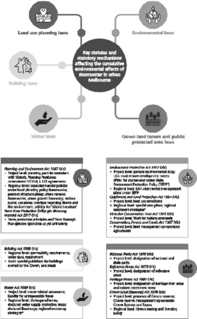
Figure 1: Summary of Statutes and Mechanisms Affecting the Cumulative Environmental Effects of Stormwater in Urban Melbourne
* Included for completeness, but discussed separately from statutory mechanisms, as establishing goals for city streams.
The first part of the exploratory spatio-legal approach presented here examines how law may allow additional stormwater flows to burden already sick city streams. It uses publicly available spatial data to aggregate ‘layers’ of key existing spatially defined (ie regional) legal mechanisms discussed in Part IV to identify gaps or ‘hotspot’ areas in which development-induced stormwater flows are more likely to arise (relative to other areas).[396] These ‘hotspots’ rely solely on ‘basic legal mechanisms’ — project-level controls that apply statewide (eg State-standard planning permit considerations, building regulations, the general environmental duty, and the liability rule for unreasonable flows). Areas that are covered by one or more of the regional mechanisms discussed above are not deemed ‘hotspots’. Potential future hotspots are contextualised by presenting standardised information on urban waterway health. Note that these hotspots relate to stormwater flows caused by DCI, and do not relate to stormwater quality, consistent with the recognition in Part II(A) that excess stormwater flows themselves adversely impact river ecology. Since planning laws deliver the most prominent legal mechanisms for addressing stormwater flows, spatial information is aggregated by LGA, as municipal councils are the key decision-makers under planning laws.[397] This produces an aggregate spatial view of the complex suite of legal controls relevant to stormwater generation, as they appear on paper, and a standardised view of Melbourne waterway health data by LGA. These data also highlight the municipalities potentially covered by the YSP, which facilitates coordinating stormwater-related actions in these areas.[398]
This approach is intended to raise further questions for exploration, rather than definitively evaluate stormwater-related legal mechanisms. Its exploratory and preliminary nature necessarily involves limitations. In categorising land as either a ‘hotspot’, or alternatively as an area covered by at least one regional legal mechanism,[399] the analysis adopts a conservative approach: it errs on the side of overestimating controls on future stormwater generation (that is, underestimating hotspots). This accommodates the potential for each mechanism to be used to its fullest extent, and highlights areas that are most likely to benefit from increased attention to regulatory change (as opposed to increased attention to implementing existing mechanisms). Future empirical research may well point to significant differences between this best-case scenario of law on paper, on the one hand, and the extent to which these controls are implemented, on the other. Crown land is treated as having an overall protective effect, since the available data do not permit analysis of individual Crown reserve management agreements, and licences and leases over Crown land.
Figure 2 shows the average stream condition of the waterways in or bordering each LGA,[400] weighted by the length of relevant stream reaches, and the waterway reaches that fall into each stream condition category (Poor, Moderate, Good, Very Good, or Excellent) used in the most recent Index of Stream Condition report,[401] with lighter shading indicating better health. The width of waterways shows the stream condition for that waterway reach, with a wider line indicating better health. Stippled areas have no relevant stream condition data available. Municipalities potentially covered by the YSP have thick black borders; the cross-hatched areas are outside the urban growth boundary.
Figure 2 shows that stream conditions vary widely across Melbourne LGAs, but are generally quite poor. Better stream health is generally found further from the CBD, with Frankston a notable exception. There is no clear pattern of differences in stream health between eastern and western Melbourne, despite industry concentration in the west.[402] Stream health in the potential YSP area also varies substantially, increasing in health in the upper catchment LGAs, but decreasing in health in the inner city LGAs, with the exception of Manningham. This is notable for the purposes of determining the YSP area: the YSP will address municipalities that suffer most from sick city streams if it includes the full area of the lower catchment LGAs, notably Stonnington (very poor health), and Melbourne, Yarra, Boroondara and Banyule (all quite poor health).
Figure 2: Ecological Health of Major Urban Streams by Local Government Area (ISC refers to index of stream condition)
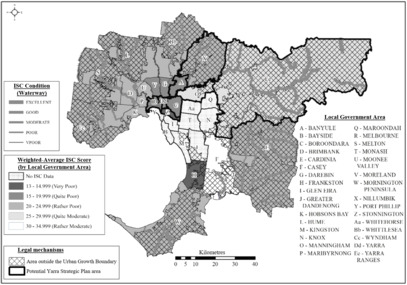
Figure 3 displays the area and percentage of land in each LGA classified as a hotspot (hotspots shown in grey, representing the gaps remaining after aggregating layers of each regional mechanism). These hotspots have comparatively high legal potential for development-induced increases in stormwater flows because no regional legal mechanism controls stormwater flows, and they rely solely on ‘basic’ mechanisms that apply statewide.
It is important to note that a causal relationship is not necessarily expected between a hotspot and poor waterway health at that location. This is because a municipality may ‘export’ the environmental effects of its lack of regional controls if the land within an LGA drains to a waterway within another municipality.[403] Conversely, it may ‘import’ other, hydrologically connected LGAs’ lack of regional controls over stormwater generation.[404] This underscores the need for a coordinated approach to improving the ecological health of urban waterways, since low levels of control (or poorly implemented controls) in one LGA may undermine the efforts of another. It confirms, in the empirical context of contemporary Melbourne stormwater management, longstanding observations that effective governance of water resources spanning functional and geographic administrative borders requires ‘coherence and institutional coordination’.[405] In addition, the data represent a snapshot in time and do not necessarily reflect areas in which high levels of historical development have ‘locked in’ adverse stormwater effects, but which subsequently introduced stormwater controls.[406]
Figure 3 shows that hotspots vary significantly across Melbourne. Many are found in northern and western municipalities: five LGAs in the north and west have hotspots over more than half of their area (Brimbank, Darebin, Hobson’s Bay, Maribyrnong and Moreland), with a minority in eastern municipalities having hotspots over more than half their area (only Glen Eira and Boroondara satisfy this threshold). This variation raises some interesting departures from common assumptions about the environmental awareness or environmental conditions of some of these LGAs. For example, some LGAs usually perceived as affluent, ‘leafy’ and environmentally aware (such as Glen Eira and Boroondara)[407] have low coverage of legal mechanisms above a basic level of protection.[408] Conversely, some less affluent LGAs with long manufacturing and industrial histories (such as Hume),[409] which might be associated with high DCI, now apply a protective regional mechanism in relation to stormwater flows.[410] This raises the possibility that increasing LGA emphasis on stormwater has not always been supported by a high level of generally applicable legal protections, but perhaps by legal arrangements at particular local sites (which are not captured in the spatio-legal analysis) or by policy-based or infrastructure-based mechanisms alone.
There is also significant variation in the proportional coverage and type of individual regional mechanisms in place across Melbourne. In both inner and outer municipalities[411] planning laws provide the greatest proportion of regional protection, but the precise mechanisms vary: local stormwater policies and public use zoning are most significant in the inner LGAs,[412] whereas the urban growth boundary and planning overlays are most significant in the outer LGAs.[413] A majority of Melbourne’s future development will occur as infill.[414] This underscores that it is at least as important for inner urban LGAs to implement stormwater controls (notwithstanding the substantial mitigation of existing DCI required for notable ecological progress) as for less-developed outer LGAs. This contrasts with the traditional regulatory focus for SCMs in Melbourne on greenfield areas.[415]
Disaggregating protections to the LGA level reveals significant variation among the regional mechanisms most used, in turn revealing the prominence of regional mechanisms in non-planning areas of law. For example, drainage schemes cover 45% of Casey and 32% of Wyndham, water supply protection areas cover 62% of Cardinia and 57% of Whittlesea, and Crown land covers 63% of the Yarra Ranges and 32% of the City of Melbourne. This supports the importance of a legal analysis of CEEs comprehensively considering a wide variety of different laws where the relevant environmental problem spans intentional and incidental legal controls over multiple legal areas. By contrast, the overriding emphasis of stormwater debates in Melbourne has focused on planning law reforms.[416] It also suggests that different areas have varying degrees of familiarity with different regional mechanisms. Reformers of stormwater arrangements might consider whether amending mechanisms already in place in an area is likely to be the most palatable approach. They should also take note that different areas will likely require varying degrees of support for implementing new arrangements, based on their experience with existing mechanisms.
The spatio-legal analysis also provides insights into the potential usefulness of a future YSP in dealing with stormwater flows. Figures 2 and 3 show that the YSP area covers a diversity of ecological conditions and degrees of regional stormwater protection (from 0% hotspots in the Yarra Ranges to 80% hotspots in Boroondara). This suggests that the YSP could be a valuable pilot to deal with stormwater CEEs — the area is reasonably representative of the kinds of physical and legal situations that could be expected across broader metropolitan Melbourne. This pilot approach may also be comparatively politically feasible, since Figure 3 suggests that it might only be necessary to introduce significantly new legal mechanisms to deal with stormwater in the small number of municipalities that presently lack significant protections (notably Boroondara, with 80% hotspots, and Manningham, with 30% hotspots). This is not to say that stormwater CEEs are adequately dealt with in the potential YSP municipalities that have low hotspot coverage, since the relevant mechanisms (for example, protective planning overlays) may not currently be used to achieve this effect — but at least the foundation for a more protective approach is present. Building on this foundation might require action ranging from minor amendments to planning schemes to ensuring that implementation is institutionally well-supported.
Figure 3: Hotspots of Legal Potential for Adverse Stormwater Effects on Urban Streams (where there is no legal mechanism to address stormwater effects above basic measures that apply across the metropolitan area)
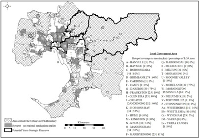
Part IV identified a large range of legal measures, across five areas of law, that could be used to address the adverse CEEs of stormwater flows. This part summarises these findings through the lens of the CEE principles outlined in Part II(B)(1). Relevant legal mechanisms include both intentionally protective mechanisms (particularly through planning and building laws), and other unintentionally protective mechanisms (notably Crown land arrangements and the urban growth boundary). Both types have some significant weaknesses. These include the ambiguity of key technical standards in the BPEM — critically, from a CEE perspective — and the frequent use of qualitative ‘reduce’- or ‘minimise’-type goals in relation to stormwater flows across a variety of legal mechanisms. By comparison, the Healthy Waterways Strategy introduced clear, quantitative and cumulative stormwater-related objectives that take account of low ecological tipping points and the diverse DCI starting points (ie existing effects) across metropolitan Melbourne — albeit without strong legal connections to mechanisms that could meet these goals.
Though a wide array of potential controls applies to the great diversity of DCI-generating developments, these controls are not entirely comprehensive: small developments, roads, and public uses that do not require planning permits remain key gaps, even after Amendment VC154. At the project level, the general environmental duty and Water Act flow liability provisions could apply comprehensively to developments regardless of size and type, but would need amendment to include adverse effects by water quantity/flows effects and to ecosystems, respectively. Similarly, permeability requirements in building regulations could be expanded beyond residential buildings. At the regional level, special area plans and environmental overlays and local stormwater policies (such as the City of Melbourne’s) under planning schemes bear promise and precedent for more comprehensively controlling stormwater effects across development types, without requiring legislative amendment. These might, perhaps, be prioritised for preparation and application to areas close to ecological tipping points, recognising that low levels of development can have significant effects.
Prominent planning law-based stormwater controls also only apply to a subset of proposed developments — a fundamental disadvantage of planning law.[417] They overlook the need to mitigate or counter the CEEs of existing impervious surfaces — for example, constructing SCMs as ecologically positive interventions. Notably, there is no clear framework for allocating legal responsibility for systematically mitigating the effects of existing developments, and SCM construction appears to depend on the policies of the State government, individual public entities and ad hoc local efforts.[418] Special area plans and statutory adjustments to the general environmental duty and flow liability provisions could provide mandatory approaches to addressing existing effects, guided by the Healthy Waterways Strategy stormwater goals. SCMs to address existing effects could also be incentivised in relation to Crown land leasing, licensing and management generally, easements, and project-level environmental statutory agreements (covenants and CFL agreements). Drainage services schemes appear to present a precedent for proposed developments ‘over-mitigating’ their effects to also counteract existing effects to some degree.[419] In practice, a combination of regional- and project-level approaches will likely be necessary to improve the existing and future effects of stormwater flows across land tenures in a way that makes minimum standards more comprehensive and addresses existing effects where this is most feasible.
Where individual decision-makers responsible for area-specific regional approaches and project-level approaches (for example, individual planning schemes, special area plans or conservation covenants) take action, they should coordinate[420] to prevent actions by one municipality compromising non-action or adverse action by another. Regional mechanisms that can span municipalities (eg special area plans) could assist. The approach of the Yarra Act presents a more modern alternative to this critical coordination.
The YSP emerges as a key opportunity to pilot a coordinated combination of regional- and project-level approaches in a State significant area, leveraging political will and receptiveness to reform. Unfortunately, the YSP’s area of application does not appear intended to cover all the land to which the Yarra is hydrologically connected,[421] and a draft YSP released shortly before the date of this publication adopts a very narrow definition that extends only to ‘land of any kind that is located within one kilometre of a bank of the Yarra River’.[422] By contrast, at its broadest, the area could encompass municipalities surrounding the Yarra, and significantly affect stormwater flows to the river. The Yarra Act’s unique purpose, recognised link with its Traditional Owners,[423] noted community importance,[424] and hydrological reality, encourage a much broader declaration of the YSP area than adopted in the current draft. Ecologically harmful stormwater flows, and Indigenous views of the Yarra,[425] are clearly not limited to land tenure of certain types or certain municipal boundaries.
The YSP is the key mechanism for implementing the Yarra Act’s uniquely broad conceptualisation of the Yarra River. Though the precise legal effect of the YSP is uncertain (since the final YSP itself will specify which parts of it are legally binding),[426] there are three main avenues for legal effect, relating to goals, preventing adverse effects, and mitigating existing and future adverse effects (ie positive interventions).
First, the Act’s 20 ‘Yarra protection principles’ must be considered when certain statutory decision-makers ‘[perform] a function ... or exercis[e] a power ... in relation to the Yarra Strategic Plan area that may affect Yarra River land’ under a vast range of Acts, including planning, transport and local government legislation,[427] catchment and water legislation,[428] and legislation relating to Crown land, forests, parks, and wildlife,[429] with an exclusion for declared major transport projects.[430] This gives the Yarra protection principles a much broader reach with stronger direct effect, compared to, for example, the current statutory catchment strategy and regional waterway strategy (assuming that the YSP area is proclaimed over the largest area possible under the Yarra Act, rather than the much smaller area contemplated by the Draft YSP).[431] The YSP will set performance objectives that will, presumably, guide how a decision-maker applies a particular Yarra protection principle. Clear and quantified performance objectives could link stormwater generation to relevant principles such as biodiversity and ecological integrity,[432] and the corresponding values as expressed in the long-term community vision for the Yarra.[433] Stormwater performance objectives under the Healthy Waterways Strategy provide an excellent starting point, aiming to go from moderate to high stormwater conditions over ‘10+ year[s]’ for the catchment as a whole,[434] with more specific targets for some (but not all) sub-catchments.[435] Quantified targets, set transparently and presented alongside current conditions, meet important CEE principles discussed in Part II(B)(1), and open the way for project-specific legal tools to be used in response to modelling of the contribution of individual developments to these targets. The YSP should adopt these quantified stormwater performance objectives, with a view to introducing this approach into a revised BPEM. The Draft YSP, however, falls short of these aspirations, adopting brief and qualitative performance objectives, such as achieving ‘[a] healthy river and lands: [i]mproving the water quality of the Yarra River and protecting its land, floodplains and billabongs to achieve greater biodiversity’.[436]
Further avenues for stormwater management arise through a land use and development framework to be included in the YSP. The preparation of this framework by Melbourne Water, its endorsement by ‘responsible public entities’, and approval by the Minister presumably attract the ‘management principle’ that ‘the best practicable measures available at the time should be used’.[437] It is unclear whether the framework is intended to be a policy plan for introducing such measures in the YSP area using existing legal vehicles such as those described in Part IV, or a standalone source of legally binding measures. The Draft YSP takes the former approach. Notably, it anticipates that future changes to planning law mechanisms will be the main way its measures are implemented, without mentioning the potential use of any of the other mechanism analysed here.[438] This article suggests that, in fact, each of the legal mechanisms reviewed in Part IV could be considered to reduce stormwater flows, and could be included in the YSP’s land use and development framework to contribute to a DCI performance objective, or at minimum, no net increase in stormwater discharge to the Yarra system.
SCMs could also emerge from the YSP’s land use and development framework identifying ‘areas for protection’.[439] One interpretation of this phrase is natural areas that are not intended to be developed, constraining new DCI and maintaining the river’s flow regime. Applying legal mechanisms such as public protected areas, or Crown reserves or other Crown land covered by public use zones with conservation objectives, could deliver this kind of protection. This appears to be the approach adopted in the Draft YSP.[440]
‘Areas for protection’ could also be interpreted as referring to areas to be protected for constructing SCMs using project-level mechanisms, such as Crown reserves or other public land types. It could also involve strategically acquiring private land, or using land that remains in private hands under legal mechanisms to secure SCM arrangements, such as s 173 agreements under the Planning and Environment Act, CFL agreements, and conservation covenants. A review of candidate parcels of land for this purpose could generate a list of potential public entities that developers could approach to deliver mitigation requirements imposed by the third YSP element, being the framework applicable to individual projects. If the final YSP adopts a geographically narrow area of application, and results in fewer legally binding constraints on DCI, there would be persuasive reason to expand the YSP’s approach to identifying ‘areas for protection’ to accommodate more SCMs, which would retain stormwater and help reduce the effects of higher DCI.
The third legal avenue for stormwater management is the YSP’s decision-making framework (not included in the Draft YSP),[441] which will include provisions for assessing and evaluating individual projects and proposals.[442] This provides scope for constraining additional stormwater flows by applying stricter DCI standards to proposed developments in the YSP area. This would require interpreting ‘areas for protection’ broadly (ie to protect all YSP land from increased net stormwater runoff) or ensuring no increase in stormwater runoff as part of the ‘broad direction for the future use and development of the Yarra Strategic Plan area’.[443] This approach to applying DCI controls could be used to ‘pilot’ revised technical guidance and quantitative flow requirements that later revisions to the BPEM could apply more broadly. A ‘no net stormwater increase’ provision would be most effective if it accounted for, and structured responsibility for offsetting, small uncontrolled developments (analogous to ratios applied in the context of biodiversity offsetting that use multipliers in calculating the offset required for native vegetation cleared).[444] This would exceed the current objective of ‘maintaining the pre-development flow regime’ adopted by the most robust regional-level mechanisms, such as some precinct structure plans.[445] It would also truly reflect a CEE-inspired approach.
Alternatively (or in addition), the decision-making framework could be accompanied by improved public land controls (eg imposing best practice stormwater management requirements, consistent with Crown leasing policy for unreserved Crown land) under regulations that apply to management planning for public protected areas, Crown reserves, licensing of unreserved Crown land, planning permit requirements in public use zones under planning schemes, and incentive-based leasing and licensing arrangements to encourage SCMs.
The YSP is an important opportunity to pilot improvements to stormwater standards with a view to later applying them more generally. State policy and legislation displays some appetite for such improvements through regional measures: for example, committing to strengthening planning controls to benefit rivers, improving residential stormwater standards, and aligning public land reservations to a future YSP.[446] However, elements of the Yarra Act[447] and recent State policy[448] tend to place greater emphasis on location-specific major investment in projects to improve waterway health. As past experience with waterway health strategies shows, overemphasising this approach risks failing to achieve desired outcomes in the presence of vague goals and unclear prioritisation methods. A project-based approach also does not question the adequacy of current minimum standards,[449] which are insufficient. A place-based approach may also be challenged by the uneven availability of municipal resources for stormwater management,[450] especially if the State government does not anticipate investing to correct these differences.[451] The project-based component of any approach to waterway health should be supported by best practice legal mechanisms that help ensure accountability for delivering and maintaining them, assessing their effectiveness, and extending them from ‘pilots’ to general practice. Victoria’s environmental history contains many ‘pilots’, for instance re-naturalising short, isolated stretches of concrete drains without larger-scale measures.[452] The YSP has promise to pilot deeper and wider action to address the CEEs of stormwater flows from both existing and future urban development.
There may also be political appetite to extend the present focus on the Yarra to Melbourne’s other urban waterways. The terms of reference for a recent ministerial advisory body hints at the potential to extend the same types of mechanisms used in the Yarra Act to Melbourne’s western rivers.[453] More substantially, planning law amendments that came into effect in May 2018 provide for declaring and protecting ‘distinctive areas and landscapes’ using mechanisms similar to those in the Yarra Act.[454] Although the amendments were developed in the context of controlling peri-urban growth in the Macedon Ranges,[455] they have clear potential to apply more broadly to stormwater effects.
The cumulative effects of stormwater flows in urban areas threaten the ecological health of city streams. In Melbourne, a profusion of policies and legal mechanisms relate to waterway health and affect stormwater generation. On paper, they operate at both the regional and project levels to prevent further adverse effects and to promote positive intervention by building stormwater infrastructure to address existing effects. Some are already in use, to varying degrees, for this purpose; many more — some of which have lain largely unused for decades — have this potential. Analysing these mechanisms having regard to CEE concepts suggests that they should cover diverse sources of stormwater more comprehensively (especially considering low ecological thresholds for cumulatively significant adverse effects), and most challengingly, allocate responsibility for addressing existing effects. These weaknesses remain even after significant changes to planning laws in late 2018. A high-level spatio-legal view of these controls reveals ‘hotspots’ of comparatively high legal potential for increased stormwater-related harm to city streams. These complex legal layers ultimately do not prevent incremental continuing damage, nor provide a convincing response to restoring ailing city streams. Further empirical research — for example, surveys of agencies tasked with implementing the controls covered here — would present a fuller picture of how these legal layers translate to action on the ground, and the challenges that these agencies experience in this context.
More positively, in augmenting the relatively slim existing literature[456] on legal responses to CEEs outside of the context of environmental impact assessment, this analysis demonstrates the breadth of potentially useful legal responses to CEE problems, and identifies a fuller range of legal mechanisms that could protect city streams than has previously been identified in Victorian policy documents[457] or scholarship. An emerging, much-anticipated mechanism, the Yarra Strategic Plan, has significant promise. It provides scope for clear goals, well-connected to legal mechanisms that are strategically coordinated to treat stormwater effects on Melbourne’s most prominent stream. If it assumes this role, and does so successfully, it could constitute an ecological antidote with promise for all city streams.
[*] BE (Hons), LLB (Hons) (Melb), JSM, JSD (Stanford); Associate Professor, Melbourne Law School, The University of Melbourne. This work is based on research funded by the University of Melbourne Early Career Researcher Grants Scheme (#502356) and the Australian Research Council (#DE180101154). The article benefited from early conversations with Bruce Lindsay, Chris Walsh, Marnie Lassen, Cecilia Riebl, Erin O’Donnell and Anna Lucas, thoughtful feedback from Amanda Cravens, Nicola Ulibarri and Anne Siders, and research assistance from Grahame Best and Jason Schroeder. The mapping work reported in Part V was undertaken by Levi Keesecker, PhD (Principal Environmental Scientist, E Squared Environmental Consulting) as instructed by the author. All errors remain those of the author.
[1] Eryk Bagshaw, ‘Melbourne Is One of the Fastest-Growing Cities in the Developed World’, The Age (online, 21 September 2018) <https://www.theage.com.au/national/victoria/melbourne-is-one-of-the-fastest-growing-cities-in-the-developed-world-20180920-p504zn.html>, archived at <https://perma.cc/WY6F-BW7H>. See generally Wayne Cole, ‘Australia’s Population Growth Outpaces World as Migrants Rush In’, Reuters (online, 14 December 2017) <https://www.reuters.com/article/us-australia-economy-population/australias-population-growth-outpaces-world-as-migrants-rush-in-idUSKBN1E80HT>, archived at <https:// perma.cc/MY3V-8FY5>.
[2] See, eg, Victorian Auditor-General, Effectively Planning for Population Growth (Parliamentary Paper No 256 of 2014–17, 23 August 2017).
[3] See, eg, John Hearsch, ‘A Blueprint for Melbourne’s Public Transport Future’, The Age (online, 15 September 2019) <https://www.theage.com.au/national/victoria/a-blueprint-for-melbourne-s-public-transport-future-20190913-p52r25.html>, archived at <https://perma.cc/T7PG-QSPS>.
[4] See below Part II(A).
[5] See Victorian Planning Authority, Arden Vision (Publication, 2018) 5, 8, 14, 20, 25–6, 37–40 (in relation to the Moonee Ponds Creek). The Yarra River is known as Birrarung to its Traditional Owners: see below Part III. For brevity, this article will refer to it as the Yarra River, chiefly because relevant legal definitions use this term.
[6] Improving Stormwater Management Advisory Committee (Vic), Final Report (Report, 4 September 2018) 16 (‘Improving Stormwater Management Report’).
[7] Ibid.
[8] Department of Environment, Land, Water and Planning (Vic), Central Region Sustainable Water Strategy Review (Report, October 2018) 55 (‘Central Region Strategy Review’); Melbourne Water, Healthy Waterways Strategy 2018 (Report, December 2018) 38, 113 (‘Healthy Waterways Strategy’).
[9] Improving Stormwater Management Report (n 6) 16; Aboriginal Heritage Regulations 2018 (Vic) regs 26–7. Note that Aboriginal cultural heritage law falls outside the scope of this paper. The Aboriginal Heritage Regulations 2007 (Vic) regs 23(1), 26(1) designate land near waterways as areas of cultural heritage sensitivity, attracting protections in relation to ‘high impact’ developments: at regs 4 (definition of ‘high impact activity’), 6, pt 2 div 5. However, this designation does not include areas of ‘significant ground disturbance’ and other significant exclusions that are likely to be common in metropolitan areas: at regs 23(2), 26(2). This is not to diminish the importance of protections for Aboriginal cultural heritage or the significance of this heritage for metropolitan areas. See also the relevance of Aboriginal cultural heritage in the more spatially certain context of the Yarra Strategic Plan: see below Part VI(B).
[10] Healthy Waterways Strategy (n 8) 30 [4.3].
[11] Geoff J Vietz et al, ‘Thinking outside the Channel: Challenges and Opportunities for Protection and Restoration of Stream Morphology in Urbanizing Catchments’ (2016) 145 Landscape and Urban Planning 34, 36.
[12] Senate Environment and Communications References Committee, Parliament of Australia, Stormwater Management in Australia (Report, December 2015) 4 [2.7]; Improving Stormwater Management Report (n 6) 15.
[13] Improving Stormwater Management Report (n 6) 17.
[14] Stormwater Management in Australia (n 12) 7–9 [2.13]–[2.21].
[15] See generally Improving Stormwater Management Report (n 6); John Phillips, ‘Planning and Environment Act 1987 ¾ Victoria Planning Provisions ¾ Notice of Approval of Amendment ¾ Amendment VC154’ in Victoria, Victoria Government Gazette, No S 509, 26 October 2018, 2 (‘Amendment VC154’).
[16] Local Government Act 1989 (Vic) ss 3C(1)–(2)(a).
[17] For spatio-legal work, and work connecting a spatial phenomenon with law in major overseas law journals, see, eg, Nicholas O Stephanopoulos, ‘Spatial Diversity’ (2012) 125(8) Harvard Law Review 1903; James M Anderson et al, ‘Reducing Crime by Shaping the Built Environment with Zoning: An Empirical Study of Los Angeles’ (2013) 161(3) University of Pennsylvania Law Review 699; Rowland Atkinson, Elizabeth Taylor and Maggie Walter, ‘Burying Indigeneity: The Spatial Construction of Reality and Aboriginal Australia’ (2010) 19(3) Social and Legal Studies 311; Lisa R Pruitt, ‘Spatial Inequality as Constitutional Infirmity: Equal Protection, Child Poverty and Place’ (2010) 71(1) Montana Law Review 1.
[18] For a recent legislative example of these silos carving out land use controls from water regulation, see Water Act 2007 (Cth) s 22(10): ‘A provision of the Basin Plan has no effect to the extent to which the provision directly regulates: (a) land use ... ; or (b) the management of natural resources (other than water resources); or (c) the control of pollution’.
[19] See, eg, Improving Stormwater Management Report (n 6); Lisa Neville, ‘Western Waterways to Get a Boost’ (Media Release, Victorian Government, 28 August 2018) (announcing a Ministerial Advisory Committee to develop the Waterways of the West Action Plan).
[20] See, eg, Productivity Commission, National Water Reform (Inquiry Report No 87, 19 December 2017) 191–200; Stormwater Management in Australia (n 12).
[21] See, eg, Sean Bothwell and Kaitlyn Kalua, ‘Balancing a Watershed Approach to Stormwater Management’ (2019) 25(2) Hastings Environmental Law Journal 263.
[22] Mandy Elliott, Environmental Impact Assessment in Australia: Theory and Practice (Federation Press, 6th ed, 2014) 61. Note that there are many more specific and sometimes disagreeing definitions of cumulative environmental effects (also, usually synonymously, cumulative environmental impacts) in use globally: see Larry W Canter, Cumulative Effects Assessment and Management: Principles, Processes and Practices (EIA Press, 2015) 5–6; Jill Gunn and Bram F Noble, ‘Conceptual and Methodological Challenges to Integrating SEA and Cumulative Effects Assessment’ (2011) 31(2) Environmental Impact Assessment Review 154, 156.
[23] Intergovernmental Panel on Climate Change, Climate Change 2014: Synthesis Report (Report, 2015) 8.
[24] Ian Cresswell and Helen Murphy, Australia State of the Environment 2016: Biodiversity (Report, 2017) vi.
[25] See generally Senate Environment and Communications References Committee, Parliament of Australia, Toxic Tide: The Threat of Marine Plastic Pollution in Australia (Report, April 2016) ch 3; Jenna R Jambeck et al, ‘Plastic Waste Inputs from Land into the Ocean’ (2015) 347(6223) Science 768; Boris Worm, ‘Silent Spring in the Ocean’ (2015) 112(38) Proceedings of the National Academy of Sciences of the United States of America 11752.
[26] Will Steffen et al, ‘Planetary Boundaries: Guiding Human Development on a Changing Planet’ (2015) 347(6223) Science 1259855:1–10; Johan Rockström et al, ‘A Safe Operating Space for Humanity’ (2009) 461(7263) Nature 472.
[27] See, eg, A John Sinclair, Meinhard Doelle and Peter N Duinker, ‘Looking Up, Down, and Sideways: Reconceiving Cumulative Effects Assessment as a Mindset’ (2017) 62 Environmental Impact Assessment Review 183, 186; Jenny Pope et al, ‘Advancing the Theory and Practice of Impact Assessment: Setting the Research Agenda’ (2013) 41 Environmental Impact Assessment Review 1, 5–6; Lennart Folkeson, Hans Antonson and JO Helldin, ‘Planners’ Views on Cumulative Effects: A Focus-Group Study concerning Transport Infrastructure Planning in Sweden’ (2013) 30(1) Land Use Policy 243, 244–5.
[28] Part III explores legal definitions of waterways. Unless the context indicates otherwise, this article uses terms like ‘river’, ‘stream’, ‘waterway’, etc synonymously.
[29] See generally Christopher J Walsh et al, ‘The Urban Stream Syndrome: Current Knowledge and the Search for a Cure’ (2005) 24(3) Journal of the North American Benthological Society 706.
[30] See, eg, Department of Environment and Primary Industries (Vic), Improving Our Waterways: Victorian Waterway Management Strategy (Report, September 2013) 254 (‘Victorian Waterway Management Strategy’). While the focus of this article is generally on protecting and restoring urban streams in terms of water quantity effects, comparisons with water quality laws and policies will be made where relevant.
[31] Improving Stormwater Management Report (n 6) 6.
[32] Stormwater Management in Australia (n 12) 32 [3.37].
[33] Improving Stormwater Management Report (n 6) 13.
[34] Healthy Waterways Strategy (n 8) 188: ‘Directly connected imperviousness (DCI) is the proportion of the impervious surface that is directly connected to a stream through a conventional drainage connection’. This is sometimes termed DCIA, or ‘directly connected impervious area’: Victorian Stormwater Committee, Urban Stormwater: Best Practice Environmental Management Guidelines (CSIRO Publishing, 1999) 242 (‘BPEM’).
[35] Healthy Waterways Strategy (n 8) 36 [5.1.2].
[36] Myles E Coker et al, ‘Alternatives to Biodiversity Offsets for Mitigating the Effects of Urbanization on Stream Ecosystems’ (2018) 32(4) Conservation Biology 789, 792–3; Christopher J Walsh et al, ‘Principles for Urban Stormwater Management to Protect Stream Ecosystems’ (2016) 35(1) Freshwater Science 398, 402 (‘Principles for Urban Stormwater Management’). See also Christopher J Walsh, Tim D Fletcher and Matthew J Burns, ‘Urban Stormwater Runoff: A New Class of Environmental Flow Problem’ (2012) 7(9) PLoS ONE e45814:1–10; Christopher J Walsh and J Angus Webb, ‘Interactive Effects of Urban Stormwater Drainage, Land Clearance, and Flow Regime on Stream Macroinvertebrate Assemblages across a Large Metropolitan Region’ (2016) 35(1) Freshwater Science 324.
[38] Walsh, Fletcher and Burns (n 36) 8–9.
[39] Stormwater Management in Australia (n 12) 8 [2.19].
[40] Ibid 7 [2.15], quoting Evidence to Senate Environment and Communications References Committee, Parliament of Australia, Canberra, 18 May 2015, 24 (Tony Wong).
[41] See Stormwater Management in Australia (n 12) 38 [3.59], citing CSIRO, Submission No 42 to Senate Environment and Communications References Committee, Parliament of Australia, Inquiry into Stormwater Management in Australia (December 2015) 3.
[42] See, eg, Christopher J Walsh et al, ‘Restoring a Stream through Retention of Urban Stormwater Runoff: A Catchment-Scale Experiment in a Social–Ecological System’ (2015) 34(3) Freshwater Science 1161.
[43] Melbourne Water, Stormwater Strategy: A Melbourne Water Strategy for Managing Rural and Urban Runoff (Report, November 2013) 14.
[44] Walsh et al, ‘Principles for Urban Stormwater Management’ (n 36) 400–2.
[45] See ibid 406–7; Improving Stormwater Management Report (n 6) 20.
[46] Walsh et al, ‘Principles for Urban Stormwater Management’ (n 36) 404, 406–7.
[47] See, eg, Victoria Planning Provisions (Vic) cl 54.03-4 (‘VPP’).
[48] Walsh et al, ‘Principles for Urban Stormwater Management’ (n 36) 399.
[49] See generally ibid.
[50] Toby Prosser, Peter J Morison and Rhys A Coleman, ‘Integrating Stormwater Management to Restore a Stream: Perspectives from a Waterway Management Authority’ (2015) 34(3) Freshwater Science 1186, 1188 (discussing the 10,000 Raingardens Program), 1191.
[51] Ibid 1187 (describing investment by the Victorian Government through Melbourne Water in the decade preceding 2015).
[52] Stormwater Management in Australia (n 12) 56–7 [5.7].
[53] Prosser, Morison and Coleman (n 50) 1190–1.
[54] Dave Owen, ‘Mapping, Modeling, and the Fragmentation of Environmental Law’ [2013] (1) Utah Law Review 219, 220.
[55] See generally Neil Gunningham and Darren Sinclair, ‘Policy Instrument Choice and Diffuse Source Pollution’ (2005) 17(1) Journal of Environmental Law 51; Robin Kundis Craig and Anna M Roberts, ‘When Will Governments Regulate Nonpoint Source Pollution? A Comparative Perspective’ (2015) 42(1) Boston College Environmental Affairs Law Review 1; Rebecca Nelson, ‘Regulating Nonpoint Source Pollution in the US: A Regulatory Theory Approach to Lessons and Research Paths for Australia’ [2011] UWALawRw 6; (2011) 35(2) University of Western Australia Law Review 340.
[56] Walsh and Webb (n 36) (referring to interacting effects of imperviousness, including increased runoff, decreased groundwater recharge, changes in channel dimensions, and aquatic biodiversity, which together produce greater than simply additive effects).
[57] Erin E Prahler et al, ‘It All Adds Up: Enhancing Ocean Health by Improving Cumulative Impacts Analyses in Environmental Review Documents’ (2014) 33(3) Stanford Environmental Law Journal 351, 356.
[58] See above Part II(A).
[59] This is the converse of recognising the potential for synergism between effects, described in the second point: Joseph M Culp, Kevin J Cash and Frederick J Wrona, ‘Cumulative Effects Assessment for the Northern River Basins Study’ (2000) 8(1) Journal of Aquatic Ecosystem Stress and Recovery 87, 88, 92; Melissa M Foley et al, ‘The Challenges and Opportunities in Cumulative Effects Assessment’ (2017) 62 Environmental Impact Assessment Review 122, 123; Prahler et al (n 57) 355–6.
[60] Prahler et al (n 57) 356.
[61] Wanda Baxter, William A Ross and Harry Spaling, ‘Improving the Practice of Cumulative Effects Assessment in Canada’ (2001) 19(4) Impact Assessment and Project Appraisal 253, 257; Daniel M Franks, David Brereton and Chris J Moran, ‘The Cumulative Dimensions of Impact in Resource Regions’ (2013) 38 Resources Policy 640, 645–6.
[62] See, eg, F Chris Jones, ‘Cumulative Effects Assessment: Theoretical Underpinnings and Big Problems’ (2016) 24(2) Environmental Reviews 187, 195, 197.
[63] Ibid 195.
[64] In relation to Australian legal scholarship, see, eg, Ralf Buckley, ‘Cumulative Environmental Impacts: Problems, Policy and Planning Law’ (1994) 11(4) Environmental and Planning Law Journal 344; Jessica T Dales, ‘Death by a Thousand Cuts: Incorporating Cumulative Effects in Australia’s Environment Protection and Biodiversity Conservation Act’ (2011) 20(1) Pacific Rim Law and Policy Journal 149; Sally Audeyev and Angela Zhao, ‘Cumulative Impact Assessment under the EPBC Act’ (2015) 34(3) Australian Resources and Energy Law Journal 223, 225; Laura Schuijers, ‘Environmental Decision-Making in the Anthropocene: Challenges for Ecologically Sustainable Development and the Case for Systems Thinking’ (2017) 34(3) Environmental and Planning Law Journal 179. In relation to risks of water contamination from increased density of septic systems, see Rozen v Macedon Ranges Shire Council [2010] VSC 583; (2010) 181 LGERA 370 (Supreme Court of Victoria). See also Environment Protection and Biodiversity Conservation Act 1999 (Cth) s 24D; 40 CFR § 1508.7 (2012). For detail regarding the (similar) US formulation, see generally Council on Environmental Quality, Considering Cumulative Effects under the National Environmental Policy Act (Handbook, January 1997); Zhao Ma, Dennis R Becker and Michael A Kilgore, ‘Barriers to and Opportunities for Effective Cumulative Impact Assessment within State-Level Environmental Review Frameworks in the United States’ (2012) 55(7) Journal of Environmental Planning and Management 961.
[66] See, eg, Environment Effects Act 1978 (Vic) s 3.
[67] See, eg, Monique G Dubé, ‘Cumulative Effect Assessment in Canada: A Regional Framework for Aquatic Ecosystems’ (2003) 23(6) Environmental Impact Assessment Review 723, 724, 726. For an individual case study, see, eg, Culp, Cash and Wrona (n 59) (relating to a rural catchment impacted by pulp mills and river impoundments).
[68] Allison J Squires and Monique G Dubé, ‘Development of an Effects-Based Approach for Watershed Scale Aquatic Cumulative Effects Assessment’ (2013) 9(3) Integrated Environmental Assessment and Management 380.
[69] Andrew Macintosh, ‘Strategic Environmental Assessment: A Solution to the Problems Associated with Project-Based Environmental Impact Assessment?’ (2013) 28(4) Australian Environment Review 541, 543–4; Bram Noble and Kelechi Nwanekezie, ‘Conceptualizing Strategic Environmental Assessment: Principles, Approaches and Research Directions’ (2017) 62 Environmental Impact Assessment Review 165, 167, 170–1.
[70] As to strategic environmental assessments in the urban land use planning context, see generally Simon Marsden, ‘Strategic Environmental Assessment in Australian Land-Use Planning’ (2013) 30(5) Environmental and Planning Law Journal 422. As an example of the terms of reference for a strategic environmental assessment that deals with water and mentions stormwater quality issues, but does not refer to adverse stormwater flow impacts, see Section 146(1) Agreement Relating to the Assessment of the Impacts of a Plan for the Protection of Matters of National Environmental Significance in the Perth and Peel Regions, Western Australia, Commonwealth–Western Australia, May 2012, 12–13.
[71] See, eg, Peter J Davies et al, ‘Urban Rivers and Riparian Systems: Directions and Recommendations for Legislators, Policy Makers, Developers and Community Users’ (2011) 28(5) Environmental and Planning Law Journal 313, 329.
[72] Lasse Baaner and Line Hvingel, ‘Spatiality of Environmental Law’ (2015) 12(2) Journal for European Environmental and Planning Law 173, 181.
[73] Ibid. As an alternate formulation, ‘“[l]aw” draws lines, constructs insides and outsides, assigns legal meanings to lines, and attaches legal consequences to crossing them’: David Delaney, ‘Legal Geography I: Constitutivities, Complexities, and Contingencies’ (2015) 39(1) Progress in Human Geography 96, 99.
[74] It is important to acknowledge that many other kinds of methodologies are useful in analysing stormwater management more generally (as opposed to spatially defined laws that control DCI). For recent works, see, eg, Yuling Gao et al, ‘Public Perception towards River and Water Conservation Practices: Opportunities for Implementing Urban Stormwater Management Practices’ (2018) 223 Journal of Environmental Management 478 (broad analysis of public perceptions regarding decentralised urban stormwater management infrastructure); Peter Dillon et al, ‘Community Perspective on Consultation on Urban Stormwater Management: Lessons from Brownhill Creek, South Australia’ (2016) 8(5) Water 170:1–15 (author-embedded analysis of community perspectives); Desmond O Anim et al, ‘Can Catchment-Scale Urban Stormwater Management Measures Benefit the Stream Hydraulic Environment?’ (2019) 233 Journal of Environmental Management 1 (application of hydrological and hydraulic models to understanding the effectiveness of SCMs); Annicka Cettner et al, ‘Assessing Receptivity for Change in Urban Stormwater Management and Contexts for Action’ (2014) 146 Journal of Environmental Management 29 (surveys and interviews with technical professionals).
[75] Barry Smit and Harry Spaling, ‘Methods for Cumulative Effects Assessment’ (1995) 15(1) Environmental Impact Assessment Review 81, 89–92; Sharon Parker and Chris Cocklin, ‘The Use of Geographical Information Systems for Cumulative Environmental Effects Assessment’ (1993) 17(5) Computers, Environment and Urban Systems 393, 393.
[76] Martijn Kuller et al, ‘What Drives the Location Choice for Water Sensitive Infrastructure in Melbourne, Australia?’ (2018) 175 Landscape and Urban Planning 92.
[77] For a recent introduction to geographic information systems in the social sciences, see Dimitris Ballas et al, GIS and the Social Sciences: Theory and Applications (Routledge, 2018).
[78] See ibid chs 5–6.
[79] See, eg, Isabella Alexander and Marlena Jankowska, ‘Rights in Geospatial Information: A Shifting Legal Terrain’ [2018] MelbULawRw 1; (2018) 41(3) Melbourne University Law Review 957; Baaner and Hvingel (n 72); Fermín Romero Vázquez and Sergio Camacho Lara, ‘What Lawyers Need to Know about Science to Effectively Make and Address Laws for Remote Sensing and Environmental Monitoring’ (2010) 36(2) Journal of Space Law 365.
[80] See, eg, Owen (n 54) 280–1; JB Ruhl, ‘A Manifesto for the Radical Middle’ (2002) 38(2) Idaho Law Review 385, 400–2. See Dave Owen and Caroline Noblet, ‘Interdisciplinary Research and Environmental Law’ (2014) 41(4) Ecology Law Quarterly 887, 905.
[81] See Jiangxiao Qiu et al, ‘Spatial Fit between Water Quality Policies and Hydrologic Ecosystem Services in an Urbanizing Agricultural Landscape’ (2017) 32(1) Landscape Ecology 59, 60.
[82] See, eg, Parker and Cocklin (n 75) 398–9.
[83] Lauren Coad et al, ‘Measuring Impact of Protected Area Management Interventions: Current and Future Use of the Global Database of Protected Area Management Effectiveness’ (2015) 370(1681) Philosophical Transactions of the Royal Society B 20140281:1–10.
[84] Chloe B Wardropper, Chaoyi Chang and Adena R Rissman, ‘Fragmented Water Quality Governance: Constraints to Spatial Targeting for Nutrient Reduction in a Midwestern USA Watershed’ (2015) 137 Landscape and Urban Planning 64, 68–70; Qiu et al (n 81) 72.
[86] Luke Bennett and Antonia Layard, ‘Legal Geography: Becoming Spatial Detectives’ (2015) 9(7) Geography Compass 406, 406.
[87] See Robyn Bartel, ‘Place-Thinking: The Hidden Geography of Environmental Law’ in Andreas Philippopoulos-Mihalopoulos and Victoria Brooks (eds), Research Methods in Environmental Law: A Handbook (Edward Elgar Publishing, 2017) 159, 172, 181. Some legal geographers do use geographic information systems: see, eg, John Page, Ann Brower and Johannes Welsch, ‘The Curious Untidiness of Property & Ecosystem Services: A Hybrid Method of Measuring Place’ (2015) 32(3) Pace Environmental Law Review 756. See especially at 765.
[88] See, eg, Stephanopoulos (n 17).
[89] See, eg, Margaret F Brinig and Nicole Stelle Garnett, ‘Catholic Schools, Charter Schools, and Urban Neighborhoods’ (2012) 79(1) University of Chicago Law Review 31.
[90] See, eg, Anderson et al (n 17).
[91] See, eg, Andrew Gorman-Murray and Chris Brennan-Horley, ‘The Geography of Same-Sex Families in Australia: Implications for Regulatory Regimes’ (2010) 28(1) Law in Context 43 (mapping same-sex households and discussing the implications of their distribution from a human rights perspective and in relation to regulatory regimes for same-sex couples).
[92] See, eg, Michael Ng, T Edwin Chow and David WS Wong, ‘Geographical Dimension of Colonial Justice: Using GIS in Research on Law and History’ (2016) 34(4) Law and History Review 1027.
[93] See Jurian Edelenbos, Nanny Bressers and Peter Scholten, ‘Introduction: Conceptualizing Connective Capacity in Water Governance’ in Jurian Edelenbos, Nanny Bressers and Peter Scholten (eds), Water Governance as Connective Capacity (Routledge, 2016) 1, 2.
[94] See generally Department of Environment and Primary Industries (Vic), Index of Stream Condition: The Third Benchmark of Victorian River Condition (Report, 2013) (‘Index of Stream Condition Report’). Note that there are other reports on waterway conditions, including statutory ‘catchment condition reports’ issued by Catchment Management Authorities (‘CMAs’), but these view waterway health in a limited way (ie as related mainly to water quality): see, eg, Port Phillip and Westernport Catchment Management Authority, Annual Report 2016–17 (Report, 2017) 43.
[95] Index of Stream Condition Report (n 94) 98 (referring to the Port Phillip region). The assessment is based on reporting using the ‘Index of Stream Condition’ method, which takes into account hydrology, physical form, the streamside zone, water quality, and aquatic life: at 100–5.
[96] This is generally the case, with a small exception in the case of the hydrology sub-index, which uses both a reference condition approach and a management target approach that is informed by matters such as community values and costs and benefits of restoration: ibid 5. However, sometimes, rather opaquely, it is reported relative to ‘management targets’.
[97] Ibid 98 (as above, referring to the Port Phillip region). Note that the condition of waterways across a significant area of metropolitan Melbourne waterways is not reported, perhaps because they were not considered ‘“priority/high value” waterways’: Victorian Waterway Management Strategy (n 30) 42; or perhaps because they have been so modified that they are usually thought of as drains. Nonetheless, replacing concrete channels with natural channels by revegetating riparian zones and improving the banks is increasingly supported, acknowledging some concerns about maintenance activities to control weeds and silt: see generally A Rahman et al, ‘Sustainable Natural Channels in Urban Areas as a Component of Water Sensitive Urban Design’ in MJ Boyd et al (eds), 28th International Hydrology and Water Resources Symposium: About Water (Institution of Engineers, Australia, 2003) vol 2, 41.
[98] See Mark Taylor and Robert Stokes, ‘Up the Creek: What Is Wrong with the Definition of a River in New South Wales?’ (2005) 22(3) Environmental and Planning Law Journal 193, 200.
[99] Ibid 201–2.
[100] Ibid 210.
[101] See, eg, Water Act 1989 (Vic) ss 3 (definition of ‘waterway’), 36(4), 51(7), 63(3) (‘Water Act’). In these sections waterway has an extended meaning. The relevant definition includes not only ‘a natural channel in which water regularly flows, whether or not the flow is continuous’, but also ‘a channel formed wholly or partly by the alteration or relocation of a waterway’, ‘a lake, lagoon, swamp or marsh’, and ‘any collection of water which is from time to time replenished in whole or in part by water coming by a natural sub-surface path from a waterway’.
[102] See, eg, ibid s 22P(1)(d).
[103] Ibid s 190(1); Catchment and Land Protection Act 1994 (Vic) s 23 (‘Catchment and Land Protection Act’).
[104] Water Act (n 101) s 185(2) (focusing on the management of waterways, drainage or floodplains); Catchment and Land Protection Act (n 103) s 24(2) (focusing on the quality of land and water resources in catchments).
[105] Catchment and Land Protection Act (n 103) s 26(1). Note that they may attain higher legal status if incorporated into two types of instruments that do have binding force, namely a planning scheme or a ‘State environment protection policy’: at s 25.
[106] Ibid ss 23, 24(2) (regional catchment strategies ‘identify objectives for the quality of the land and water resources’ and priority areas for attention); Water Act (n 101) s 189(1)(bb). Melbourne Water must prepare a regional waterway strategy for its waterway management district to perform this function of an authority with a waterway management district: at s 190(1).
[107] Victorian Auditor-General, Effectiveness of Catchment Management Authorities (Parliamentary Paper No 364 of 2010–14, 17 September 2014) 19–23 (note that the audit involved a sample of four CMAs, which did not include the CMAs for Greater Melbourne or Port Phillip and Westernport: at ix); Melbourne Water, Draft Healthy Waterways Strategy (Report, 6 July 2018) 139 (noting that priorities were not ‘well recorded or reproducible’).
[108] Water Act (n 101) s 22B (sustainable water strategies).
[109] Central Region Strategy Review (n 8) 52. See also Department of Environment, Land, Water and Planning (Vic), Integrated Water Management Framework for Victoria: An IWM Approach to Urban Water Planning and Shared Decision Making throughout Victoria (Report, September 2017) 8 (‘Integrated Water Management Framework’) (listing numerous, very general ‘[w]ater-related outcomes to deliver resilient and liveable cities and towns’, such as ‘[w]aterway health is maintained and improved’, ‘[w]ater is prominent in the urban landscape’, and ‘[w]aterways [are] accessible as valuable open space’). Similarly, Melbourne’s multi-decadal planning strategy describes a vision to ‘[i]ntegrate urban development and water cycle management to support a resilient and liveable city’ and ‘[p]rotect and restore natural habitats’: Department of Environment, Land, Water and Planning (Vic), Plan Melbourne 2017–2050 (Metropolitan Planning Strategy, 2017) 13 (‘Plan Melbourne 2017–50’).
[110] The nine key values are amenity, community connection, recreation, birds, fish, frogs, macroinvertebrates, platypus and vegetation: Healthy Waterways Strategy (n 8) 15.
[111] Ibid 16–17.
[112] Ibid 70.
[113] Ibid 57.
[114] See, eg, ibid 115–16 (in relation to rivers in the Yarra catchment).
[115] See above Part II(B)(1).
[116] Healthy Waterways Strategy (n 8) 188.
[117] See below Part IV.
[118] Eric Biber and Josh Eagle, ‘When Does Legal Flexibility Work in Environmental Law?’ (2015) 42(4) Ecology Law Quarterly 787, 790.
[119] Yarra River Protection (Wilip-gin Birrarung murron) Act 2017 (Vic) s 1(a) (‘Yarra Act’). For a more detailed discussion of this legislation, see Katie O’Bryan, ‘The Changing Face of River Management in Victoria: The Yarra River Protection (Wilip-gin Birrarung murron) Act 2017 (Vic)’ (2019) 44(6–7) Water International 769; Bruce Lindsay, ‘Higher and Distinctive Standards for River Protection? Special Purpose “River Laws” and Land Use Planning’ (2020) 37 Environmental and Planning Law Journal (forthcoming).
[120] Yarra Act (n 119) pt 2 (for example, amenity, public health and wellbeing, recreation; Aboriginal cultural values, heritage and knowledge; and post-settlement cultural diversity and heritage).
[121] See, eg, ibid s 9(2) (the environment-related Yarra protection principles refer merely to ‘maintain[ing]’ or ‘enhanc[ing]’ environmental aspects).
[122] The most that can be said is that some (mostly social) principles are expressed with goals to maintain and improve, or only improve, conditions: see, eg, ibid ss 8(3) (‘Decision-makers should take into account the impact of any individual action or policy on public health and wellbeing and seek to ensure that public health and wellbeing is enhanced by the action or policy’), 10(1) (protecting and enhancing ‘[t]he existing amenity of Yarra River land’). By contrast, other (mostly environmental) principles accept the possibility of only ‘maintain[ing]’ conditions, or are otherwise qualified (ie seeking ‘net gain’ for the environment where a policy or action would have an environmental impact on Yarra River land; seeking the ‘best practicable environmental outcome’; or maintaining or enhancing biodiversity and ecological integrity ‘in ways that are proportionate to the significance of the environmental risks and consequences being addressed’): at ss 9(2)–(4). No social consideration is similarly qualified: at ss 8(1), (4), 10.
[123] See, eg, Water Act 2007 (Cth) s 3(d).
[124] Yarra Act (n 119) ss 17(2), 20(1)(a).
[125] Four separate river reaches are defined in the following way: upper rural (Upper Yarra Dam to Healesville), lower rural (Healesville to Warrandyte), suburban (Warrandyte to Dights Falls), and inner-city (Dights Falls to Port Phillip Bay): Melbourne Water, Yarra River 50-Year Community Vision: Wilip-gin Birrarung murron (Report, May 2018) 8–9 (‘Yarra River 50-Year Community Vision’).
[126] See, eg, ibid 13 (in relation to the lower rural reach, ‘improved biodiversity ... [for the] habitat corridor and surrounding billabongs’), 15 (in relation to the suburban reach, ‘new habitat for endangered birds, fish and wildlife’), 17 (in relation to the inner-city reach, stating the ambivalent goal to balance the ‘needs of our growing city’ with ‘future environmental health of the river’).
[127] Yarra Act (n 119) ss 20(2)(b)–(c). Performance objectives could also potentially apply to land in the broader Yarra catchment, if declared by the Planning Minister: at ss 15(1), (3) (including, as land to which the YSP applies, land declared by the Planning Minister that is located more than one kilometre from a bank of the Yarra River that falls within certain named municipal areas). In relation to that broader area of land, the YSP may ‘cover any other matter relating to waterway health, river parklands amenity, landscape amenity or environmental, cultural or heritage values that the Minister [directs be covered]’: at s 20(2)(i). This could, theoretically, include setting relevant performance objectives for this broader area of land if the Minister so directs.
[128] The draft YSP and associated preparatory documents are available at Department of Environment, Land, Water and Planning (Vic), ‘Help Us Shape the Final 10-Year Strategic Plan for the Yarra River’, Engage Victoria (Web Page) <https://engage.vic.gov.au/help-us-shape-final-10-year-strategic-plan-yarra-river>, archived at <https://perma.cc/RLL2-QSFR>.
[129] See below Part VI(B).
[131] Ibid s 15.
[132] Ibid s 14. It cannot include land that is ‘excluded land’ or that is owned privately or by a municipal council: at s 14(3)(c).
[133] Ibid ss 15(3), 19(1). A declaration has already been made as to ‘Yarra River land’, whereas no declaration is yet in place in relation to the land to which the Yarra Strategic Plan applies: Andrew Robinson, ‘Yarra River Protection (Wilip-gin Birrarung murron) Act 2017 — Declaration of Yarra River Land — Order in Council’ in Victoria, Victoria Government Gazette, No G 5, 1 February 2018, 192. For discussion of how a recently released draft of the YSP treats this matter, see below n 422 and accompanying text.
[134] For example, parts of the Moonee Valley and Whittlesea LGAs are within the Yarra catchment: Healthy Waterways Strategy (n 8) 67, 70. However, the Yarra Act (n 119) does not countenance that the YSP area might cover area in this municipality: at s 15(3).
[135] Some have identified lack of legislative mandate as a key barrier to sustainable urban stormwater management: Allison H Roy et al, ‘Impediments and Solutions to Sustainable, Watershed-Scale Urban Stormwater Management: Lessons from Australia and the United States’ (2008) 42(2) Environmental Management 344, 349.
[136] I note recent arguments that federal intervention, guidance and funding is warranted: see generally Stormwater Management in Australia (n 12) ch 5. More specifically, an Australian Senate Environment and Communications References Committee recommendation in late 2015 to formulate a National Stormwater Initiative has not come to fruition: at 71 [6.12].
[137] See David N Bengston, Jennifer O Fletcher and Kristen C Nelson, ‘Public Policies for Managing Urban Growth and Protecting Open Space: Policy Instruments and Lessons Learned in the United States’ (2004) 69(2–3) Landscape and Urban Planning 271; Andrew Macintosh, Anita Foerster and Jan McDonald, ‘Policy Design, Spatial Planning and Climate Change Adaptation: A Case Study from Australia’ (2015) 58(8) Journal of Environmental Planning and Management 1432.
[138] Environmental Justice Australia, ‘Rivers of the West: Options and Models for Better Legal and Policy Protections’ (Policy Paper, 22 May 2018) 2; Improving Stormwater Management Report (n 6).
[139] ‘Amendment VC154’ (n 15).
[140] See, eg, Meluka Bancroft and Alex Gardner, ‘Opportunities and Obligations for Residential Developers to Undertake Wastewater Recycling and Stormwater Capture: A Western Australian Perspective’ (2015) 32(4) Environmental and Planning Law Journal 372; Davies et al (n 71). Beyond legal scholarship, many other disciplines have contributed large bodies of knowledge in areas related to stormwater controls and governance: see generally Quentin Grafton et al (eds), Understanding and Managing Urban Water in Transition (Springer, 2015); Hale W Thurston (ed), Economic Incentives for Stormwater Control (CRC Press, 2012); Xiu-Juan Qiao, Anders Kristoffersson and Thomas B Randrup, ‘Challenges to Implementing Urban Sustainable Stormwater Management from a Governance Perspective: A Literature Review’ (2018) 196 Journal of Cleaner Production 943; Krishna P Dhakal and Lizette R Chevalier, ‘Urban Stormwater Governance: The Need for a Paradigm Shift’ (2016) 57(5) Environmental Management 1112.
[141] That is, land that, by statute, is the property of the Commonwealth or the State of Victoria. As will become evident below, I include in this category Crown land that is leased or licensed to others. I treat all Crown land as a potential ‘regional’ legal approach to addressing stormwater CEEs because the relevant statutes apply to multiple parcels of land managed by public entities. Although in some cases an entity manages a single parcel of land (eg a committee of management for a Crown reserve: Crown Land (Reserves) Act 1978 (Vic) s 14 (‘Crown Land (Reserves) Act’)) rather than multiple parcels (eg Parks Victoria: ‘What We Manage’, Parks Victoria (Web Page) <https://parkweb.vic.gov.au/about-us/who-we-are/what-we-manage>, archived at <https://perma.cc/3DZ3-RLTZ>), the overarching statute provides for a level of control over multiple parcels in a way that differs fundamentally from private land in its level of governmental control.
[142] Note that laws providing for the designation of protected areas with a focus on public land are dealt with here in the exploration of protections that apply to Crown land, rather than as environmental laws: see below Part IV(D). This is the case with heritage river areas and natural catchment areas under the Heritage Rivers Act 1992 (Vic) (‘Heritage Rivers Act’): see at s 1 (‘The purpose of this Act is to make provision for Victorian heritage rivers by providing for the protection of public land in particular parts of rivers and river catchment areas’); and reference areas, which may only apply to public land: Reference Areas Act 1978 (Vic) ss 3–4 (‘Reference Areas Act’).
[143] Sandford D Clark and Ian A Renard, ‘The Riparian Doctrine and Australian Legislation’ [1970] MelbULawRw 13; (1970) 7(4) Melbourne University Law Review 475, 483–4.
[144] National Parks Act 1975 (Vic) Preamble para (c) (‘National Parks Act’) (recognising the importance of reserving ‘areas in or adjacent to urban areas of natural beauty or interest or otherwise suitable for recreational use’).
[145] Definitions of public land amenable to the establishment of protected areas vary according to the legislative scheme. For example, under the Reference Areas Act (n 142) s 2, ‘public land’ is defined as:
(a) any unalienated land of the Crown, including land temporarily or permanently reserved under the Crown Land (Reserves) Act 1978;
(b) State forest, within the meaning of the Forests Act 1958;
(c) park, within the meaning of the National Parks Act 1975;
(d) land vested in any public authority, other than [a municipal council or the sewerage district of a water authority under the Water Act 1989].
[146] Ibid s 3 (referring to preservation in its natural state); National Parks Act (n 144) s 32H (referring to designated water supply catchment areas). Note that these are not necessarily the same as the water supply areas declared under the Catchment and Land Protection Act (n 103), since the relevant terms are independently defined under the National Parks Act (n 144) s 3(1) (definitions of ‘designated water supply catchment area’, ‘Melbourne water supply catchment area’). Note that other types of zones (eg wilderness zones and remote and natural areas) do not occur within the boundaries of metropolitan Melbourne: at schs 5–6. For a similar formulation, see Heritage Rivers Act (n 142) ss 7(2), 12 (in relation to natural catchment areas, and prohibiting uses and activities including clearing indigenous flora, harvesting timber, mineral exploration, grazing, introducing non-indigenous fauna, making or upgrading roads, and discharging effluent).
[147] National Parks Act (n 144) ss 17(2)(ba), 19G (noting the exceptions listed).
[148] Heritage Rivers Act (n 142) schs 3–4.
[149] Note that relevant constraints on such developments may theoretically apply under a management plan for a specific protected area: National Parks Act (n 144) ss 17(2)(d) (providing for the Secretary to prepare a plan of management for each national park and State park), 18(2)(d) (providing for the Secretary to prepare a plan of management for each other park); ibid ss 8–9 (management plans for heritage river area or natural catchment area, which must include matters specified by the Minister for that management plan). Note that although regulations under this Act may provide for ‘the control, management and use of heritage river areas’: at s 18(1)(a). There are none currently in effect.
[150] Crown Land (Reserves) Act (n 141) s 4.
[151] Ibid s 8(1).
[152] Ibid s 4(1)(e).
[153] Ibid ss 4(1)(l)–(m), (n)–(o), (w)–(x), (ze).
[154] Ibid ss 4(1)(b)–(c), (i)–(j), (p)–(r), (v), (za), (zc).
[155] Tim D Fletcher et al, ‘Restoration of Stormwater Retention Capacity at the Allotment-Scale through a Novel Economic Instrument’ (2011) 64(2) Water Science and Technology 494, 498–9.
[156] In the Little Stringybark Creek catchment, a council road upgrade that followed public funding of SCMs on private land had this unfortunate effect, attributed to ‘an early lack of shared commitment, communication, and common understanding of project objectives between departments’ of the council: Prosser, Morison and Coleman (n 50) 1189.
[157] Crown Land (Reserves) Act (n 141) ss 13(1)(b)(ii), (iiia).
[158] Regulations covering very specific matters do exist: see, eg, Crown Land (Reserves) (Domestic Firewood) Regulations 2012 (Vic); Crown Land (Reserves) (Tour Operator Licence Fee) Regulations 2011 (Vic).
[159] Crown Land (Reserves) Act (n 141) s 18B.
[160] Ibid s 13(1)(b)(x)(B).
[161] Water Industry Act 1994 (Vic) s 4I; Minister for Environment, Climate Change and Water (Vic), Water Industry Act 1994: Statement of Obligations (General) (20 December 2015).
[162] Crown Land (Reserves) Act (n 141) ss 18C, 21AB.
[163] See below Part VI(B).
[164] Department of Environment, Land, Water and Planning (Vic), Leasing Policy for Victorian Crown Land (Policy, May 2018) 5, 14.
[165] Ibid 15.
[166] See below Part IV(B).
[167] See Banyule City Council, A Management Plan for the Improvement of Urban Stormwater Quality for the Banyule City Council (Project No WC01727, 12 February 2003) vol 2, 46 (‘Banyule Stormwater Management Plan’).
[168] Department of Environment, Land, Water and Planning (Vic), Riparian Management Licences: To Protect the Riparian Environment (Publication, 2015).
[169] Land Act 1958 (Vic) s 407 (on the Minister’s own motion or on the advice of the relevant municipal council). Note that municipal councils must be notified of the grant, transfer, amendment and cancellation of licences to enter and use water frontages: at s 411.
[170] See Vietz et al (n 11) 36.
[171] Victorian Planning Authority, Defence Site Maribyrnong (Statement of Policy Intent, June 2018) (adjacent to the Maribyrnong River). See generally ‘Defence Site Maribyrnong’, Victorian Planning Authority (Web Page) <https://vpa.vic.gov.au/project/defence-site-maribyrnong/>, archived at <https://perma.cc/V796-WWGD>.
[172] Airports Act 1996 (Cth) s 136(1) (‘Airports Act’); Melbourne Airport, Melbourne Airport Master Plan 2018 (Report, 2018) 13 (‘Melbourne Airport Master Plan 2018’).
[173] Airports Act (n 172) s 112(2); Melbourne Airport Master Plan 2018 (n 172) 13.
[174] Essendon Airport, Master Plan 2013 (Report, 2013) 28, 103–4 (noting that runoff from Essendon Airport discharges to the Moonee Ponds Creek).
[175] Melbourne Airport Master Plan 2018 (n 172) 242–3, 246. Melbourne Airport is adjacent to the Moonee Ponds Creek, the Maribyrnong River and Deep Creek, among other waterways: at 32.
[176] Planning laws can influence only new developments: Planning and Environment Act 1987 (Vic) s 6(3)(e) (‘Planning and Environment Act’) (prohibiting a planning scheme from requiring alterations to ‘lawfully constructed building[s] or works’).
[177] Ibid s 16 (with the exception of land use and development on Commonwealth land as described above).
[178] Plan Melbourne 2017–50 (n 109) 121.
[179] See, eg, the terms of reference for Victoria’s recent Improving Stormwater Management Advisory Committee: Improving Stormwater Management Report (n 6) 10.
[180] ‘Amendment VC154’ (n 15) 2.
[181] See generally Planning and Environment Act (n 176) pt 2.
[182] ‘About Planning Schemes’, Department of Environment, Land, Water and Planning (Vic): Planning Schemes Online (Web Page) <https://planning-schemes.delwp.vic.gov.au/about>, archived at <https://perma.cc/S3G2-5KWR>.
[183] Ibid. See also VPP (n 47) cl 30.
[184] ‘About Planning Schemes’ (n 182). See, eg, VPP (n 47) cls 42.01–42.01-5.
[185] Planning and Environment Act (n 176) ss 60, 61(1), 62 (in relation to conditions); VPP (n 47) cl 65.01.
[186] Planning and Environment Act (n 176) s 55.
[187] Plan Melbourne 2017–50 (n 109) 47.
[188] Planning and Environment Act (n 176) s 3(1) (definition of ‘urban growth boundary’), pt 3AA div 3.
[189] Alan Thatcher, ‘The Future of the Green Wedges’ (2015) 41(2) Planning News 24, 24 (referring to land uses permitted within the Green Wedge Zone).
[190] Victorian Government, Using Victoria’s Planning System: A Technical Guide to Interpretation and Administrative Procedures under the Planning and Environment Act 1987 and the Planning and Environment Regulations 2015 and Their Interaction with Other Related Legislation and Planning Schemes (Guide) 15.
[191] VPP (n 47) cls 36.01 (Public Use Zone), 36.02 (Public Park and Recreation Zone), 36.03 (Public Conservation and Resource Zone). Note that I exclude cl 36.04 (Road Zone) from my definition of ‘public land zone’, since this land use inherently involves an impermeable surface. Other forms of zoning are, for example, for the purposes of residential, commercial, industrial, road or similar uses: at cls 32–4.
[192] Department of Environment, Land, Water and Planning (Vic), Public Land Zones (Planning Practice Note No 2, January 2018) 1 (‘Planning Practice Note 2’). Not all public land is covered by a public use zone; this is only intended to be used where there is some difference in the nature of the public use of the land and the surrounding zones. Public use zones may also cover land that is not Crown land, such as freehold land owned by municipal councils.
[193] VPP (n 47) cls 36.02 (‘Purpose’ of Public Park and Recreation Zone), 36.03 (‘Purpose’ of Public Conservation and Resource Zone).
[194] This includes works such as educational, utility, and local government facilities: ibid cls 36.01-1, 36.01-6 (‘Permit not required’ for Public Use Zone); pathways, trails, shelters and offices: at cls 36.02-1–36.02-2 (‘Permit not required’ for Public Park and Recreation Zone); and roads, car parks, interpretation centres and caravan parks: at cls 36.03-1–36.03-2 (‘Permit not required’ for Public Conservation and Resource Zone).
[195] Ibid cl 36.01-6 (referring to categories of public land use).
[196] Ibid cl 53.18-1.
[197] Planning Practice Note 2 (n 192) 2.
[198] See above Part IV(A).
[199] Department of Environment, Land, Water and Planning (Vic), ‘Issues Paper for the Improving Stormwater Management Advisory Committee’ (Paper, June 2018) 9, 11; VicRoads, Integrated Water Management Guidelines (Guidelines, June 2013) 15.
[200] Grainne Oates and Amir Moradi-Motlagh, ‘Is Voluntary Disclosure of Environmental Performance Associated with Actual Environmental Performance? Evidence from Victorian Local Governments, Australia’ (2016) 23(2) Australasian Journal of Environmental Management 194, 203.
[201] Plan Melbourne 2017–50 (n 109) 5.
[202] VPP (n 47) cl 37.07. Note that Precinct Structure Plans (‘PSPs’) apply within the Urban Growth Zone.
[203] Ibid cl 37.07-9. Note that no PSP is currently in place or planned for any land adjacent to the Yarra River: Victorian Planning Authority, ‘VPA Greenfields Planning’, Interactive Status Map (Web Page, 2019) <https://vpa.vic.gov.au/greenfield/interactive-status-map/>. However, Urban Growth Zones are located adjacent to, and in the catchments of, tributaries to the Yarra River (see, eg, adjacent to Edgars Creek: Department of Environment, Land, Water and Planning (Vic), Whittlesea Planning Scheme (Map Nos 10–11)); and adjacent to other rivers and creeks in greater and western Melbourne (see, eg, adjacent to the Kororoit Creek: Department of Environment, Land, Water and Planning (Vic), Melton Planning Scheme (Map Nos 9, 14)).
[204] They may be implemented through a combination of local planning policy framework statements, design and development overlays, development contributions plan overlays to ‘[levy] contributions for the provision of works, services and facilities before development can commence’, and a structure plan and associated strategies, with some listed in the planning scheme as reference documents: Melbourne Planning Scheme (Vic) cl 45.06 (‘Melbourne Planning Scheme’). See, eg, arrangements for the Arden urban renewal precinct in northern inner Melbourne: at cls 21.14-2 (proposed urban renewal areas: Arden-Macaulay), 43.02 (design and development overlay), 43.02 sch 63, 45.06, 45.06 sch 2 (Macaulay Urban Renewal Area Development Contributions Plan); Arden Vision (n 5).
[205] BPEM (n 34). See, eg, Metropolitan Planning Authority, Lincoln Heath South (Precinct Structure Plan, September 2015) 15–16 (‘Lincoln Heath South PSP’). See below Part IV(C).
[206] See, eg, Metropolitan Planning Authority, Woodlands (Precinct Structure Plan, September 2016) 15 requirement 15.
[207] See, eg, Growth Areas Authority, East Werribee Employment Precinct (Precinct Structure Plan, October 2013) 51 guideline 94. See also Growth Areas Authority, Manor Lakes (Precinct Structure Plan, March 2012) 35 [4.5.5]; Growth Areas Authority, Merrifield West (Precinct Structure Plan, June 2018) 25 requirement 80 (‘Merrifield West PSP’); Growth Areas Authority, Lockerbie (Precinct Structure Plan, May 2012) 57 guideline 57; Victorian Planning Authority, Botanic Ridge (Precinct Structure Plan, May 2017) 36 requirement 14.
[208] See, eg, Growth Areas Authority, Black Forest Road South (Precinct Structure Plan No 42.2, April 2013) 25 requirement 77 (‘Black Forest Road South PSP’).
[209] See, eg, Victorian Planning Authority, Mt Atkinson & Tarneit Plains (Precinct Structure Plan, June 2017) 47.
[210] See, eg, Victorian Planning Authority, Rockbank (Precinct Structure Plan, August 2016) 43 (referring only to stormwater quality-related ‘performance objectives’ set out in a best management practices document); Growth Areas Authority, Taylors Hill West (Precinct Structure Plan, May 2010) 21 (referring only to stormwater quality issues).
[211] Metropolitan Planning Authority, Clyde Creek (Precinct Structure Plan, February 2014) 9 objective 15; Metropolitan Planning Authority, Casey Central Town Centre (Precinct Structure Plan, May 2016) 11 objective 30.
[212] See, eg, Lincoln Heath South PSP (n 205) 15–16.
[213] See, eg, Black Forest Road South PSP (n 208) 25 requirement 75. See below Part IV(E).
[214] See, eg, Victorian Planning Authority and Hume City Council, Greater Broadmeadows (Framework Plan, December 2017) 3.
[215] Ibid 7.
[216] Arden Vision (n 5) 37–40.
[217] Planning and Environment Act (n 176) pt 3AAB.
[218] Andrew Robinson, ‘Planning and Environment Act 1987 — Declaration of Macedon Ranges as a Distinctive Area and Landscape — Order in Council’ in Victoria, Victoria Government Gazette, No G 33, 16 August 2018, 1806, 1808.
[219] These are the Floodway Overlay: VPP (n 47) cl 44.03; Land Subject to Inundation Overlay: at cl 44.04; and Special Building Overlay: at cl 44.05. See also the Urban Floodway Zone: at cl 37.03. See generally Department of Environment, Land, Water and Planning (Vic), Applying the Flood Provisions in Planning Schemes: A Guide for Councils (Planning Practice Note No 12, June 2015) (‘Applying the Flood Provisions in Planning Schemes’).
[220] VPP (n 47) cls 44.03 (‘Purpose’ of Floodway Overlay, which includes ‘protect[ing] ... waterways as natural resources’), 44.04 (‘Purpose’ of Land Subject to Inundation Overlay, which includes ‘ensur[ing] that development maintains or improves river and wetland health [and] waterway protection’). Clause 44.03-4 requires a flood risk report to be prepared to accompany a planning permit application where no local floodplain development plan applies. The report must consider ‘[t]he effect of the development on river health values including wetlands, natural habitat, stream stability, erosion, environmental flows, water quality and sites of scientific significance’. See similar requirements at cl 44.04-8 (Land Subject to Inundation Overlay).
[221] Applying the Flood Provisions in Planning Schemes (n 219) 1–2.
[222] As a minor exception to this, for the purposes of applying the Urban Floodway Zone, ‘environmental values’ are considered in calculating flood risks: VPP (n 47) cl 37.03-4. Accordingly, this zone applies to relatively narrow bands of flood-prone land, primarily adjacent to streams: ibid 12–13.
[223] See, eg, Vegetation Protection Overlay: VPP (n 47) cl 42.02; Significant Landscape Overlay: at cl 42.03; Erosion Management Overlay: at cl 44.01; and Salinity Management Overlay: at cl 44.02.
[224] See, eg, ibid (n 47) cl 44.02-6 (Salinity Management Overlay, which requires an application to be accompanied by an assessment of the water balance for the current and proposed land uses, proximate waterways, wetlands and environmental features, and high recharge and discharge areas).
[225] See, eg, ibid cls 12.03-1S, 12.05-1S. Associated documents such as the Healthy Waterways Strategy (n 8) are cited at cl 12.03-1S.
[226] See, eg, VPP (n 47) cl 44.02-9 (Salinity Management Overlay).
[227] See, eg, ibid cls 42.02 (Vegetation Protection Overlay), 42.03 (Significant Landscape Overlay).
[228] Melbourne Water, Little Stringybark Creek Environmental Significance Overlay: Review and Future Directions (Report) 6 (‘Little Stringybark Creek Overlay Review’).
[229] Yarra Ranges Planning Scheme (Vic) cl 42.01 sch 2 [2.0] (‘Yarra Ranges Planning Scheme’).
[230] Fletcher et al (n 155) 496, 499 (emphasis omitted); Prosser, Morison and Coleman (n 50) 1188.
[231] Fletcher et al (n 155) 496–8 (noting that ‘benefits’ took into account water quality, runoff reduction, and water conservation).
[232] See Little Stringybark Creek Overlay Review (n 228) 12.
[233] Yarra Ranges Planning Scheme (n 229) cl 42.01 sch 2. Note that the overlay controls initially took effect through a string of interim overlays: Stuart Menzies, ‘Planning and Environment Act 1987 — Yarra Ranges Planning Scheme — Notice of Approval of Amendment — Amendment C167’ in Victoria, Victoria Government Gazette, No G 16, 19 April 2018, 765, 765; Stuart Menzies, ‘Reasons for Decision to Exercise Power of Intervention under Section 20(4) of the Planning and Environment Act 1987: Yarra Ranges Planning Scheme Amendment C167’ (4 April 2018) (‘Amendment C167 Reasons for Decision’). The current version of the Environmental Significance Overlay (‘ESO’) makes these arrangements permanent: ‘Amendment C164: Yarra Ranges Planning Scheme’, Department of Environment, Land, Water and Planning (Vic): Planning (Web Page, 2019) <https://www.planning.vic.gov.au/schemes-and-amendments/browse-amendments?query=c164#Amendments--C164>.
[234] Yarra Ranges Planning Scheme (n 229) cl 42.01 sch 2 [3.0]–[4.0]. Other decision guidelines are also relevant in the case that the standard treatments are not achieved: at cl 42.01 sch 2 [5.0].
[235] Little Stringybark Creek Overlay Review (n 228) 14–15.
[236] Ibid 3–4.
[237] That is, high feasibility of household-scale SCMs relative to large-scale systems and demand for stormwater re-use: ibid 14.
[238] Fletcher et al (n 155) 497. Impervious areas connected to conventional stormwater were around 5.5%.
[239] The costs of applying for planning permits and giving and receiving associated hydrological advice were locally acceptable in the area: Little Stringybark Creek Overlay Review (n 228) 11, 18 (noting that socio-economic characteristics vary widely in Melbourne). The ESO applies to approximately 1,200 properties in Mount Evelyn: ‘Amendment C167 Reasons for Decision’ (n 233) [4]–[5]. The median weekly household income in Mount Evelyn is $1,655, compared to $900 in Broadmeadows, in the upper catchment of the Moonee Ponds Creek, another tributary of the Yarra River: Australian Bureau of Statistics, ‘Mount Evelyn’, 2016 Census QuickStats (Web Page, 12 July 2019) <https://quickstats.censusdata.abs.gov.au/census_services/getproduct/census/2016/quickstat/SSC21783>, archived at <https://perma.cc/MY3V-8FY5>; Australian Bureau of Statistics, ‘Broadmeadows’, 2016 Census QuickStats (Web Page, 12 July 2019) <https://quickstats.censusdata.abs.gov.au/census_services/getproduct/census/2016/quickstat/SSC20344>, archived at <https://perma.cc/R9DV-7D7N>.
[240] Little Stringybark Creek Overlay Review (n 228) 13, 17 (eg exempting small developments from requiring a permit, and placing greater reliance on self-evaluation and technical guidance materials).
[241] Melbourne Planning Scheme (n 204) cl 22.23.
[242] Ibid cl 22.23-1. See also at cl 22.23-2.
[243] Ibid cl 22.23-2, citing BPEM (n 34) 15 (referring to quantitative water quality performance objectives).
[244] Melbourne Planning Scheme (n 204) cl 22.23-3.
[245] Ibid cl 22.23-5.
[246] Ibid cl 22.23-4 (referring to the software models STORM and MUSIC, or equivalent).
[247] Maroondah Planning Scheme (Vic) cl 22.01-3 (Waterways Protection Policy).
[248] Casey Planning Scheme (Vic) cl 22.05-3 (Stormwater Policy).
[249] See, eg, Yarra Planning Scheme (Vic) cls 22.16, 22.16-4 (‘Yarra Planning Scheme’); Stonnington Planning Scheme (Vic) cls 22.18, 22.18-4; Port Phillip Planning Scheme (Vic) cls 22.12, 22.12-4; Moonee Valley Planning Scheme (Vic) cls 22.03, 22.03-4.
[250] See, eg, Monash Planning Scheme (Vic) cl 22.04-4 (applying differential levies for impervious areas created over 35 m2).
[251] Improving Stormwater Management Report (n 6) 24.
[252] See below Part IV(B)(2)(b).
[253] Planning and Environment Act (n 176) s 60; VPP (n 47) cl 65.01.
[254] VPP (n 47) cls 53.18-7, 65.01; ‘Amendment VC154’ (n 15).
[255] VPP (n 47) cl 14.02-1S (Catchment planning and management).
[256] Ibid cl 19.03-3S (Integrated water management).
[257] Ibid (listed under ‘Policy documents’); BPEM (n 34).
[258] Coker et al (n 36) 794. See also Matthew J Burns et al, ‘Hydrologic Shortcomings of Conventional Urban Stormwater Management and Opportunities for Reform’ (2012) 105(3) Landscape and Urban Planning 230; Christopher J Walsh, Tim D Fletcher and Anthony R Ladson, ‘Stream Restoration in Urban Catchments through Redesigning Stormwater Systems: Looking to the Catchment to Save the Stream’ (2005) 24(3) Journal of the North American Benthological Society 690.
[259] This is defined as maintaining stormwater discharges at the 1.5-year average recurrence interval flood: BPEM (n 34) 218. An ‘average recurrence interval’ (‘ARI’) refers to ‘the likelihood of occurrence, expressed in terms of the long-term average number of years, between flood events as large as or larger than the design flood event’: ‘Glossary of Terms’, Flood Victoria (Web Page, 7 March 2018) <https://www.floodvictoria.vic.gov.au/learn-about-flooding/glossary-and-abbreviations/glossary-of-terms>, archived at <https://perma.cc/EQ4H-M86L>.
[260] Improving Stormwater Management Report (n 6) 20.
[262] For example, in the 2015 case of Hoy v Wangaratta City Council [2015] VCAT 1377, the objectives of an urban commercial zone outweighed a Council’s refusal of a permit, supported by the relevant CMA, to develop a riparian parcel within the State Planning Policy Framework buffer, where the buffer had low ecological quality: at [36], [37], [44] (Member David).
[263] See ‘Issues Paper for the Improving Stormwater Management Advisory Committee’ (n 199) 14.
[264] VPP (n 47) cl 53.18-4; ‘Amendment VC154’ (n 15).
[266] Ibid.
[267] Ibid cls 53.18-4 (Standard W1), 56.07-4 (Standard C25).
[268] Ibid.
[269] Ibid cl 56.07-4.
[270] Ibid cls 55.07-5 (Standard B39 — for apartment developments less than five storeys), 58.03-8 (Standard D13 — for apartment developments of five storeys or higher). See also at cl 32.04-14.
[271] Ibid cls 53.18-7, 55.07-5, 58.03-8 (Decision guidelines).
[272] See Matthew Potter and Sharyn RossRakesh, ‘Implementing Water Sensitive Urban Design through Regulation’ in Rainwater and Urban Design 2007 (Engineers Australia, 2007).
[273] VPP (n 47) cls 53.18-4, 56.07-4.
[274] Ibid cl 53.18-1.
[275] See above n 22 and accompanying text (definition of ‘CEE’); Part II(B)(1).
[276] Department of Environment, Land, Water and Planning (Vic), ‘Smart Planning: Reforming the Victoria Planning Provisions’ (Discussion Paper, October 2017) 73–4 (‘Smart Planning’).
[277] Improving Stormwater Management Report (n 6) 30, 37.
[278] Planning and Environment Act (n 176) s 173. See also at s 13(2)(a).
[279] Ibid s 174(2).
[280] Ibid ss 4(1)(b)–(c).
[281] ‘Smart Planning’ (n 276) 68.
[282] See, eg, Moonee Valley City Council and Moonee Valley Racing Club Inc, Planning Agreement: Racecourse Residential and Mixed Use Precinct (Dealing No AQ569425F, 21 November 2017) sch 1 (relating to the land comprising part of the Moonee Valley Racecourse, requiring financial contributions, public open space contributions, and traffic mitigation works to a total value of $131,000). The agreement is available to be inspected at the offices of the Moonee Valley City Council.
[283] Note that there appears to be no comprehensive data on the extent of use of s 173 agreements, much less analyses of the purposes for which they are used or the extent to which they relate to land outside of the development site. Telephone inquiries with representatives of the Department of Environment, Land, Water and Planning (Vic), and a random selection of local councils on 13 September 2018, suggested that these entities do not keep lists or maps that show, in the aggregate, parcels of land over which s 173 agreements have been registered. Responsible authorities must keep copies of s 173 agreements available to inspect free of charge at their offices: Planning and Environment Act (n 176) s 179(2), but appear to only provide facilities to search whether an individual land title has a s 173 agreement applied to the title. The same is true in relation to the Register of Titles, on which the agreements are recorded: at s 181. However, in a qualitative sense, the agreements are reported as applying to stormwater management infrastructure: Improving Stormwater Management Report (n 6) 32.
[284] See Planning and Environment Act (n 176) s 173.
[285] Property and Environmental Law Section, Law Institute of Victoria, Submission to Department of Sustainability and Environment (Vic), Review of the Role of s173 Agreements: Discussion Paper (30 September 2004) 3.
[286] There is precedent for this approach in relation to other elements of restoring urban waterways: see, eg, MLP Corporation Pty Ltd v Moreland City Council [2017] VCAT 1566 [2], [67] (Senior Member Baird) (in the context of riparian planting).
[287] Planning and Environment Act (n 176) s 175.
[288] Ibid s 126.
[289] Ibid s 133.
[290] ‘Smart Planning’ (n 276) 68.
[291] See Building Act 1993 (Vic) s 16 (‘Building Act’). Note that ‘building’ is defined as including ‘structure, temporary building, temporary structure and any part of a building or structure’: at s 3(1) (definition of ‘building’).
[293] Building Regulations 2018 (Vic) regs 72, 77 (‘Building Regulations’). This may be varied for reasons that include consistency with existing development on the allotment: Victorian Building Authority, Siting and Design of Single Dwellings (Minister’s Guideline No MG-12, June 2006) 3. Note that a ‘class 1 building’ is a house: Building Regulations (n 293) reg 12; Australian Building Codes Board, Building Code of Australia (2019) vol 1, pt A6.1. This requirement is also mirrored in VPP (n 47) cl 55.03-4 (Standard B9), which applies to two or more dwellings on a lot and residential buildings: at cl 32.04-14.
[294] See above n 37 and accompanying text.
[295] Building Regulations (n 293) reg 10; Australian Building Codes Board, Building Code of Australia (2019) vol 2, pt 3.12.0.
[296] The take-up rate is reported at between 18% and 30%, which is low relative to other states, and uncertainty about potential adoption of tanks challenges water authorities in planning for neighbourhood-scale SCMs to deal with residual stormwater: ‘Issues Paper for the Improving Stormwater Management Advisory Committee’ (n 199) 16; Improving Stormwater Management Report (n 6) 31.
[297] ‘Issues Paper for the Improving Stormwater Management Advisory Committee’ (n 199) 16.
[298] Improving Stormwater Management Report (n 6) 8.
[299] Building Act (n 291) s 220. These only apply to buildings owned by the Crown or a public authority other than a council.
[300] Road Management Act 2004 (Vic) s 37 (‘Road Management Act’).
[302] Austroads, Guide to Road Design Part 5: Drainage — General and Hydrology Considerations (3.1st ed, August 2018) 29–44.
[303] VicRoads, VicRoads Supplement to the Austroads Guide to Road Design: Part 5 (Supplement, July 2013) 5–6.
[304] Integrated Water Management Guidelines (n 199) 29.
[305] Improving Stormwater Management Report (n 6) 32.
[306] Road Management Act (n 300) s 22(1)(b).
[307] Environment Protection Act 2017 (Vic) s 25(1) (‘Environment Protection Act’), as amended by Environment Protection Amendment Act 2018 (Vic) s 7 (emphasis added). This will come into force on 1 July 2020: Linda Dessau, Governor, ‘Environment Protection Amendment Act 2018 — Proclamation of Commencement’ in Victoria, Victoria Government Gazette, No S 104, 3 March 2020, 1.
[308] See, eg, Environment Protection Act 1997 (ACT) s 22(1); Environmental Protection Act 1994 (Qld) s 319(1).
[309] Improving Stormwater Management Report (n 6) 34–5.
[310] Environment Protection Act 1970 (Vic) ss 13(1)(c), 16 (‘Environment Protection Act 1970’); Environment Protection Agency (Vic), State Environment Protection Policy (Waters of Victoria): Our Water, Our Future! (Policy Impact Assessment, June 2003) 67–8 (explaining the policy intent behind cl 46 concerning urban stormwater).
[311] Andrew Robinson, ‘Environment Protection Act 1970 — State Environment Protection Policy (Waters) — Order in Council’ in Victoria, Victoria Government Gazette, No S 499, 23 October 2018, 1, pt III (‘Waters SEPP’). In this context, the state environment protection policy for water would guide decision-making under the Environment Protection Act 1970 (n 310) in relation to conditions of licences and approvals to discharge waste, to inform a determination of whether a pollution offence has occurred, etc: Department of Environment, Land, Water and Planning (Vic), SEPP Waters Review (Policy Impact Assessment, December 2017) 11.
[312] ‘Waters SEPP’ (n 311) pts II–III.
[313] Ibid cl 34(4).
[314] See, eg, Banyule Stormwater Management Plan (n 167) 24–5.
[315] See, eg, Moreland City Council, Integrated Water Management Plan: 2009/10–2012/13 (Report, 2009) 36.
[316] Integrated Water Management Framework (n 109) 16.
[317] See, eg, Moreland City Council, Moreland Watermap 2020: Moreland’s Path to a Water Sensitive City (Report, 2014) 22.
[318] Water and Catchment Legislation Amendment Act 2019 (Vic) pt 4 (‘Water and Catchment Act’).
[319] Catchment and Land Protection Act (n 103) s 11(1); Effectiveness of Catchment Management Authorities (n 107) ix. In the Melbourne metropolitan area, the relevant CMA is the Port Phillip and Westernport CMA: Helen Doye, ‘Catchment and Land Protection Act 1994 — Abolition of the Port Phillip Catchment and Land Protection Region and Determination of the Port Philip and Westernport Catchment and Land Protection Region and the Definition of Its Boundaries — Order in Council’ in Victoria, Victoria Government Gazette, No G 44, 31 October 2002, 2942, 2942–3. For a discussion of this legislation, see A Gardner et al, Water Resources Law (LexisNexis Butterworths, 2nd ed, 2018) 129 [6.7], 131 [6.10], 135 [6.21].
[320] No provision restricts the type of land that may be designated a special area.
[321] Catchment and Land Protection Act (n 103) ss 27(1)–(2). Note that similarly named ‘water supply protection area[s]’ are declared under the Water Act (n 101) s 27(1). The focus of management plans for these plans is managing the extraction of water to protect resources, rather than land use, in a way that could affect stormwater generation: at s 32A. See below Part IV(E)(1) for further discussion.
[322] Catchment and Land Protection Act (n 103) ss 27(3)(b)–(c).
[323] See above Part II(A).
[324] Catchment and Land Protection Act (n 103) s 28.
[325] Ibid s 30(1).
[326] Ibid s 32(4).
[327] Ibid s 31.
[328] Ibid s 32(1).
[329] SEPP Waters Review (n 311) 11.
[330] ‘Waters SEPP’ (n 311) cl 34(2).
[331] Ibid cl 34 (explanatory notes).
[332] Ibid cl 34(2)(a).
[333] Improving Stormwater Management Report (n 6) 11.
[334] Department of Environment, Land, Water and Planning (Vic), State Environment Protection Policy (Waters) (Policy Impact Assessment, October 2018) 117–22.
[335] Statutory restrictions on their content are narrow, restricting their application only in relation to mining, exploration, and unlawful land uses: Catchment and Land Protection Act (n 103) ss 33(3)–(4).
[336] Ibid s 35. See also at s 34.
[337] Ibid ss 30(3), 33(1), (2)(b).
[338] JF Allinson, Jim Barry Lewis and Michael P Papworth, ‘Protection of Rural and Urban Water Supply Catchments in Victoria’ in MJ Boyd et al (eds), 28th International Hydrology and Water Resources Symposium: About Water (Institution of Engineers, Australia, 2003) vol 3, 281, 283–4.
[339] ‘Declared Special Water Supply Catchment Areas’, Agriculture Victoria (Web Page, 12 April 2019) <http://vro.agriculture.vic.gov.au/dpi/vro/vrosite.nsf/pages/landuse-water-supply-catchments> , archived at <https://perma.cc/3NTT-2W2J>; ‘Declared Special Water Supply Catchment Areas: Tabulated Information’, Agriculture Victoria (Web Page, 12 April 2019) <http://vro.agriculture.vic.gov.au/dpi/vro/vrosite.nsf/pages/dwsc_areas> , archived at <https://perma.cc/7NEJ-KZ77>.
[340] ‘Declared Special Water Supply Catchment Areas’ (n 339).
[341] See, eg, RD Hall, ‘Soil Conservation and Land Utilization Act 1958 — Djerriwarrh Reservoir Water Supply Catchment ¾ Notice of Determination of Land-Use’ in Victoria, Victoria Government Gazette, No 60, 8 July 1964, 2182, 2182–3 cl 5; WJ Crawley, ‘Soil Conservation and Land Utilization Act 1958 — Gisborne–Sunbury Water Supply Catchment — Notice of Determination of Land-Use’ in Victoria, Victoria Government Gazette, No 5, 18 January 1961, 115, 115 cl 4.
[342] See, eg, Hall (n 341) 2183 cl 6; Crawley (n 341) 115 cl 6.
[343] SW Ransome and RG Patrick, Report on a Proposed Land Use Determination for the Rosslynne Reservoir (Jackson Creek): Water Supply Catchment (Report, April 1977) 11–12. See PG Fern, ‘Soil Conservation and Land Utilization Act 1958 — Rosslynne Reservoir (Jackson Creek) Water Supply Catchment — Notice of Determination of Land Use’ in Victoria, Victoria Government Gazette, No 39, 18 May 1977, 1320.
[344] See, eg, Lisa Neville, Minister for Water (Vic), ‘Catchment and Land Protection Act 1994 — Notice of Statement of Obligations’ in Victoria, Victoria Government Gazette, No G 3, 18 January 2018, 68; Lisa Neville, Minister for Water (Vic), ‘Catchment and Land Protection Act 1994: Statement of Obligations for Catchment Management Authorities’ (2018) cl 18.1 (containing only one sentence related to special area plans); Effectiveness of Catchment Management Authorities (n 107) (no mention of special areas plans); Department of Environment, Land, Water and Planning (Vic), Our Catchments, Our Communities: Integrated Catchment Management in Victoria 2016–19 (Report, 2016) (no mention of special area plans). See generally Catchment and Land Protection Act (n 103) s 19E.
[345] Water and Catchment Act (n 318) s 122.
[346] See, eg, the general emphasis on ‘advising’, ‘promoting’, ‘supporting’ and ‘coordinating’ in the Port Phillip and Westernport CMA’s Corporate Plan, but no mention of its regulatory role, nor special areas: Port Phillip and Westernport Catchment Management Authority, Corporate Plan 2016–17 to 2020–21 (Report, April 2016).
[347] Victorian Conservation Trust Act 1972 (Vic) s 3A(1) (‘Victorian Conservation Trust Act’); Conservation, Forests and Lands Act 1987 (Vic) ss 3(1) (definition of ‘agreement’), 69 (‘Conservation, Forests and Lands Act’).
[348] Victorian Conservation Trust Act (n 347) s 3A(1).
[349] Conservation, Forests and Lands Act (n 347) s 69(1).
[350] See, eg, Liam Mannix, ‘Meet Landowners Who Value Property Conservation over Development’, The Age (online, 13 July 2018) <https://www.theage.com.au/national/victoria/meet-landowners-who-value-property-conservation-over-development-20180709-p4zqfk.html>, archived at <https://perma.cc/RC84-EFWH>: ‘“[H]e always fenced off the area around the creek — because he thought there was something special about it” ... Late in life, much to the shock of his own family, the farmer applied for a covenant’.
[351] Department of Environment and Primary Industries (Vic), Sub-Regional Species Strategy for the Growling Grass Frog (Report, May 2013) 23–5, 35–6 (‘Sub-Regional Species Strategy’). This describes a government intention to seek CFL agreements to facilitate large-scale restoration activities in designated conservation areas, including constructing 400 on- and off-stream wetlands as habitat for endangered Growling Grass Frogs, including associated stormwater wetlands. Relevant sites are intended to be either secured by CFL agreements over the next two decades or transferred to the Crown.
[352] Victorian Conservation Trust Act (n 347) s 3A(1); Conservation, Forests and Lands Act (n 347) ss 70(1)(a)–(c), (n).
[353] Conservation, Forests and Lands Act (n 347) ss 68, 70(1)(f)–(g).
[354] Trust for Nature, Annual Report 2016–17 (Report, September 2017) 6 (‘Trust for Nature Annual Report 2016–17’).
[355] Ibid 6. See also Victorian Conservation Trust Act (n 347) s 3B; Conservation, Forests and Lands Act (n 347) s 75.
[356] Conservation, Forests and Lands Act (n 347) s 70(1)(k).
[357] Trust for Nature Annual Report 2016–17 (n 354) 6.
[358] Conservation, Forests and Lands Act (n 347) s 71(2).
[359] Ibid ss 71(1)(b) (binding on and enforceable by or against the landowner and Secretary), 77 (remedies for breach of agreement), 78 (Secretary may apply for an injunction to restrain a breach of the agreement).
[360] The statutory provisions for covenants lack an equivalent of the provision referred to directly below in n 361, which enables a fixed term arrangement.
[361] Conservation, Forests and Lands Act (n 347) s 76(1)(b).
[362] Noting that the procedure for removing a covenant potentially involves public submissions and action by the relevant Minister and even the Governor: Victorian Conservation Trust Act (n 347) ss 3A(3)–(10).
[363] Trust for Nature, Submission to Department of Environment, Land, Water and Planning (Vic) and Environment Protection Authority (Vic), State Environment Protection Policy (Waters) Review (18 June 2018).
[364] The ‘Western Melbourne ranges and plains’ landscape contains ‘significant areas of riparian habitat on private land’ and the ‘Yarra–Cardinia Catchments’ focal landscape contains ‘private land along the Yarra River, a Nationally Important Wetland, and other riparian habitat on private land’: Trust for Nature, Statewide Conservation Plan for Private Land in Victoria (Report, 2013) 36, 39.
[365] See above Part IV(B).
[366] See Sub-Regional Species Strategy (n 351) 35–6.
[367] Victorian Conservation Trust Act (n 347) s 3A(1); Conservation, Forests and Lands Act (n 347) s 69(1).
[368] See, eg, Water Act (n 101) s 51. Note that this includes, more recently, licensing arrangements for taking stormwater from stormwater infrastructure: Peter Walsh, Minister for Water (Vic), ‘Water Act 1989: Policies for Managing Take and Use Licences’ (2 February 2014) cl 9A (Licensing of stormwater), made pursuant to Water Act (n 101) div 2 pt 4.
[369] Central Region Strategy Review (n 8) 18–22.
[371] Ibid s 205.
[372] Ibid ss 196, 268.
[373] Ibid ss 27, 32A.
[374] Ibid s 32A(3)(i).
[375] Planning and Environment Act (n 176) s 55.
[376] Water Act (n 101) s 205.
[377] Ibid s 206(3).
[378] Ibid ss 208–9.
[379] These are also called development services schemes in designated greenfield areas and (more rarely) redevelopment services schemes in established areas experiencing concentrated further growth: Melbourne Water, Principles for Provision of Waterway and Drainage Services for Urban Growth (Report, June 2007) 6, 15 (‘Principles for Provision of Waterway and Drainage Services’). This policy is supported by the Water Act (n 101) ss 196, 268, and by drainage conditions in planning permits: Email from Natisse Grimshaw, Melbourne Water to Jason Schroeder, 18 September 2018. Note that the term ‘drainage services scheme’ is also used.
[380] Principles for Provision of Waterway and Drainage Services (n 379) 5–6. See also ‘Stormwater Offsets Explained’, Melbourne Water (Web Page, 2 December 2019) <https://www.melbournewater.com.au/planning-and-building/developer-guides-and-resources/drainage-schemes-and-contribution-rates-1-1>, archived at <https://perma.cc/A8Q9-TWJ7>.
[381] Principles for Provision of Waterway and Drainage Services (n 379) 8 (outlining a typical size requirement of 0.4 ha).
[382] Ibid 16, 18.
[383] Potter and RossRakesh (n 272) 888.
[384] Principles for Provision of Waterway and Drainage Services (n 379) 9.
[385] Improving Stormwater Management Report (n 6) 33.
[386] See, eg, Interjurisdictional Environmental-Economic Accounting Steering Committee, Environmental Economic Accounting: A Common National Approach (Strategy and Action Plan, April 2018); Department of Environment, Land, Water and Planning (Vic), Valuing and Accounting for Victoria’s Environment: Strategic Plan 2015–2020 (Report, 2015).
[387] See above n 307 and accompanying text.
[389] Note that one commentator considers this to be an open question, at least in relation to the former aspect of large subdivisions: Robert Sadler, ‘When the Water Flows’ (2017) 91(12) Law Institute Journal 37, 38.
[390] Water Act (n 101) ss 20(1)(a), (2).
[391] See ibid s 20(1)(c).
[392] See above Part IV(B)(1)(c).
[393] Water Act (n 101) s 136.
[394] Ibid s 148.
[395] Ibid s 16.
[396] For the reasons discussed above in Part IV, an area of land that is not covered by any of the regional legal mechanisms listed below is deemed a ‘hotspot’. Each item in the list is preceded by the part of this article that discusses it, and followed by the name of the dataset and the corresponding URL relating to that mechanism accessed from Victorian Government, ‘Datasets’, Data Vic (Web Page) <https://www.data.vic.gov.au/data/group/spatial-data>, with exceptions as noted. Data were accessed and downloaded between June 2018 and October 2018, and some changes may be expected to have occurred since this date (for example, due to amendments to planning schemes). However, these changes are not expected to be significant at the scale and for the purposes for which the data is presented here, namely the exploratory approach outlined below in the main text of Part V.
See above Part III: Shapefile provided by Email from Tony Dupcinov, Planning Mapping Services, Department of Environment, Land, Water and Planning (Vic) to Rebecca Nelson, 30 July 2018 (Yarra River land).
See above Part IV(A)(1): Department of Environment, Land, Water and Planning (Vic), ‘Vicmap Property Simplified 1: Vicmap Property’, Data Vic (Web Page) <https://www.data.vic.gov.au/data/dataset/vicmap-property-simplified-1-vicmap-property>; Department of Environment, Land, Water and Planning (Vic), ‘Public Land Management Overlay: Heritage River’, Data Vic (Web Page) <https://www.data.vic.gov.au/data/dataset/public-land-management-overlay-heritage-river> (Crown land including heritage river areas, natural catchment areas, national parks and reference areas).
See above Part IV(B)(1)(a): Department of Environment, Land, Water and Planning (Vic), ‘Vicmap Planning’, Data Vic (Web Page) VMPLAN_PLAN_UGB <https://www.data.vic.gov.au/data/dataset/vicmap-planning> (land outside the urban growth boundary).
See above Part IV(B)(1)(b): Department of Environment, Land, Water and Planning (Vic), ‘Vicmap Planning’, Data Vic (Web Page) VMPLAN_PLAN_ZONE <https://www.data.vic.gov.au/data/dataset/vicmap-planning> (public use zone, public park and recreation zone, public conservation and resource zone).
See above Part IV(B)(1)(c): Victorian Planning Authority, ‘Precinct Structure Plan Boundaries’, Data Vic (Web Page, 6 September 2018) <https://www.data.vic.gov.au/data/dataset/precinct-structure-plan-boundaries> (Precinct Structure Plan). Note that spatial data for framework plans for urban renewal precincts are not publicly available and are not released by the Victorian Planning Authority, and are therefore not included in the present mapping exercise: Email from Tyler Agius, GIS Specialist, Victorian Planning Authority to Rebecca Nelson, 24 July 2018.
See above Part IV(B)(1)(d): Department of Environment, Land, Water and Planning (Vic), ‘Vicmap Planning’, Data Vic (Web Page) VMPLAN_PLAN_ZONE, VMPLAN_PLAN_OVERLAY <https://www.data.vic.gov.au/data/dataset/vicmap-planning> (Floodway Overlay; Land Subject to Inundation Overlay; Special Building Overlay; Urban Floodway Zone; Vegetation Protection Overlay; Significant Landscape Overlay; Erosion Management Overlay; and Salinity Management Overlay).
See above Part IV(B)(1)(e): Manually created shapefile based on the following LGAs, created from a search of planning schemes with a focus on stormwater-specific controls as at 22 October 2018: Bayside, Casey, Hume, Kingston, Maroondah, Melbourne, Monash, Moonee Valley, Port Phillip, Stonnington, Yarra (Local Planning Policy Framework referring to stormwater controls, such as water sensitive urban design). Note that these are treated uniformly as a regional-level mechanism applicable to the entire relevant LGA.
See above Part IV(D)(1): Department of Environment, Land, Water and Planning (Vic), ‘Designated Water Supply Catchments’, Data Vic (Web Page) <https://www.data.vic.gov.au/data/dataset/designated-water-supply-catchments> (water supply catchment areas).
See above Part IV(E)(1): Drainage services schemes provided by Email from Iain Scott, Mapping Analyst, Melbourne Water to Rebecca Nelson, 5 June 2018; Department of Environment, Land, Water and Planning (Vic), ‘Victoria Flood Database: Defined and Declared Floodways’, Data Vic (Web Page) <https://www.data.vic.gov.au/data/dataset/victoria-flood-database-defined-and-declared-floodways> (declared floodways); Department of Environment, Land, Water and Planning (Vic), ‘Water Supply Protection Areas (Groundwater and Surface Water) within Victoria’, Data Vic (Web Page) <https://www.data.vic.gov.au/data/dataset/water-supply-protection-areas-groundwater-surface-water-within-victoria> (water supply protection areas).
[397] Data processing and analysis were undertaken using the ArcGIS (Esri) software package. Initial data processing was undertaken to ensure all the data were in the same projected coordinate system and clipped to the study extent for continuity, accuracy, and processing time. Original data were supplied in a geographic coordinate system (GCS_GDA_1994) and projected to GDA94_MGA_zone_55. This allowed calculation of LGA area in km2 based on the ad_lga_area_merge_mga55.shp shapefile. Shapefiles supplied with spatial extents larger than the study area were clipped to the extent of the metropolitan LGAs using the ‘Clip’ tool. Separate shapefiles were created for each of the legal mechanisms listed in n 396, based on the corresponding source shapefiles. The goal of this analysis was to calculate the absolute area and percentage LGA area of each mechanism within each individual LGA. Shapefiles were created for individual LGA boundaries and the area covered by each legal mechanism in each LGA. In order to determine the spatial extent of ‘hotspots’ in each LGA not covered by any regional protective legal mechanism, that is areas in which only ‘basic legal mechanisms’ are used (as noted in Figure 3 and discussed above n 396 and accompanying text), a shapefile was created from a union of all geographic scopes of interest. The union of these geographic scopes was clipped to, and then erased from, the LGA boundaries (using the ‘Clip’ and ‘Erase’ tools), in order to create a shapefile representing ‘hotspot’ areas in each LGA, and to carry out area calculations.
[398] See below Part VI.
[399] No appropriate spatial data is publicly available for the project-level mechanisms that are specific to individual landholdings (ie s 173 agreements, CFL agreements, conservation covenants and easements) that are expected to be used, in any case, over relatively small aggregate areas of generally private land.
[400] Note that since waterways form some local government boundaries, these lengths of boundary streams are intentionally counted twice — one for each LGA on either side of the waterway. This approach is consistent with the hydrological fact that water from each LGA would typically flow to that waterway. Stream health information available in tabular form was joined to the spatial data using the ‘Join’ function for unique identification numbers for designated stream reaches. Total stream length was calculated for each LGA using a buffer for the LGA of 5 m (applying the ‘Buffer’ tool), then this slightly larger boundary (incorporating any streams that served as a boundary for the LGA) was used to clip the index of stream condition (‘ISC’) shapefile boundary (applying the ‘Clip’ tool) to enable calculation of the total stream length per category of health (which is given by a number between 12 and 44), to then calculate a weighted average for each LGA, shown in Figure 2. The weighted average takes account of the differing lengths of streams in each category. Note that the buffering approach creates a very small amount of error in that it adds up to 5 m of a given stream that is outside of the metropolitan boundary in the analysis. However, given that the overall stream lengths involved are in the hundreds of kilometres, this degree of error is acceptably small.
[401] See Department of Environment, Land, Water and Planning (Vic), ‘2010 Index of Stream Condition: Full Set of ISC2010 Data Sets’, Data Vic (Web Page) <https://discover.data.vic.gov.au/dataset/2010-index-of-stream-condition-full-set-of-isc2010-data-sets>, archived at <https://perma.cc/PWN9-NDRT>; Email from Paul Wilson, Senior Manager Water Resource Information, Water Resource Strategy Division, Water and Catchments, Department of Environment, Land, Water and Planning (Vic) to Levi Keesecker, 21 June 2018 (tabular data on stream health: summary of ISC scores, conditions, and other metrics, by reach (unique ID)).
[402] See generally ‘Manufacturing in Melbourne’s West’, LeadWest (Web Page, 2019) <http://www.leadwest.com.au/Melbournes-West/The-Regional-Economy-in-Melbournes-West/Manufacturing-in-Melbournes-West> , archived at <https://perma.cc/KZ2M-6RAL>.
[403] See Walsh et al, ‘Principles for Urban Stormwater Management’ (n 36) 402.
[404] See ibid.
[405] Janice Gray, Cameron Holley and Rosemary Rayfuse, ‘The Challenge of Trans-Jurisdictional Water Law and Governance’ in Janice Gray, Cameron Holley and Rosemary Rayfuse (eds), Trans-Jurisdictional Water Law and Governance (Routledge, 2016) 3, 5.
[406] Notably, the densely developed inner city municipality of Yarra introduced its local planning policy framework for stormwater management, which applies throughout the municipality, in March 2014: Yarra Planning Scheme (n 249) cl 22.16.
[407] See generally Gay Alcorn, ‘“Kick Up the Backside”: Libs Contemplate the Unthinkable in Higgins’, The Guardian (online, 5 May 2019) <https://www.theguardian.com/australia-news/2019/may/05/kick-up-the-backside-libs-contemplate-the-unthinkable-in-higgins>, archived at <https://perma.cc/G56J-YWS4>; Calla Wahlquist, ‘Kooyong: Climate Change Shakes Up the Election in Liberal Melbourne’, The Guardian (online, 10 April 2019) <https://www.theguardian.com/australia-news/2019/apr/10/kooyong-climate-change-federl-election-melbourne-liberal-heartland>, archived at <https://perma.cc/W4YL-AMPJ>.
[408] The hotspot levels for these LGAs are 90% for Glen Eira and 80% for Boroondara: see below Figure 3.
[409] Hume City Council, The Hume Economic Development Strategy 2030 (Report) 4, 7, 13.
[410] Hume Planning Scheme (Vic) cl 53.18-4 (Standard W1).
[411] I define ‘inner municipalities’ as the inner metropolitan LGAs of Melbourne and Yarra, and the adjacent suburbs; I define ‘outer municipalities’ as the remaining LGAs.
[412] This observation is made based on calculations of the percentage coverage of individual protection mechanisms, which are shown in aggregated form, for each LGA: see below Figure 3. For example, local stormwater policies were calculated as covering over a third of the area of inner municipalities, but less than 15% of the (admittedly much greater) area of outer municipalities; ‘public use zones’ (see above n 191) cover about one fifth of the area of the inner municipalities, but less than 2% of the area of outer municipalities.
[413] No land in the inner municipalities lies outside the urban growth boundary, but around three quarters of the land in the outer municipalities lies outside this boundary; environmental overlays (see above n 223) cover over half of the land in the outer municipalities but just over 10% of the land in the inner municipalities.
[414] Improving Stormwater Management Report (n 6) 20.
[415] Kuller et al (n 76) 92–3.
[416] See generally Improving Stormwater Management Report (n 6).
[417] See above n 176 and accompanying text.
[418] See, eg, above nn 50, 251, 316 and accompanying text.
[419] See above n 384 and accompanying text.
[420] For example, waterway restoration plans involving improvements to stormwater management may be undertaken by multiple municipal councils together with Melbourne Water: see, eg, Melbourne Water et al, Chain of Ponds: Moonee Ponds Creek Plan (Report, 2018); ‘Chain of Ponds Collaboration’, Melbourne Water (Web Page, 11 November 2019) <https://www.melbournewater.com.au/what-we-are-doing/works-and-projects-near-me/all-projects/chain-ponds-collaboration>, archived at <https://perma.cc/GM8J-D4YV> (a collaboration between 15 organisations, including Melbourne Water, Moreland City Council and Moonee Valley City Council).
[421] See above n 134 and accompanying text.
[422] Victorian Government, Yarra Strategic Plan: A 10 Year Plan for the Yarra River Corridor — Draft for Public Consultation (Report, 2020) 131 (‘Draft YSP’).
[423] Explanatory Memorandum, Yarra River Protection (Wilip-gin Birrarung murron) Bill 2017 (Vic) 1.
[424] Victoria, Parliamentary Debates, Legislative Assembly, 22 June 2017, 2021–2 (Richard Wynne, Minister for Planning).
[425] Rebecca Nelson, Lee Godden and Bruce Lindsay, Cultural Flows: A Multi-Layer Plan for Cultural Flows in Australia (Report, 2018) 2, 36.
[426] Yarra Act (n 119) s 20(2)(h). The Draft YSP (n 422) states that no part of it is directly legally binding: at 43.
[427] Yarra Act (n 119) ss 62, 80, 89–90, 92, as enacted.
[428] Ibid ss 70, 94–5, as enacted.
[429] Ibid ss 74–5, 77, 82, 85, 98, as enacted.
[430] See, eg, ibid s 62, as enacted. This likely excludes decision-making about the planned North East Link road project, including a tunnel underneath the Yarra River that has raised environmental concerns about impacts on the River: North East Link Project and Victorian Government, North East Link Technical Summary (Report, August 2017) 31; Clay Lucas, ‘North East Link’s Footprint Grows amid Fears Project Will “Trash” Yarra’, The Age (online, 19 June 2018) <https://www.theage.com.au/politics/victoria/north-east-link-s-footprint-grows-amid-fears-it-will-trash-the-yarra-20180619-p4zmb0.html>, archived at <https://perma.cc/YX3Q-3VMX>.
[431] Catchment and Land Protection Act (n 103) ss 25–6; Planning and Environment Act (n 176) s 46AZJ(5); Water Act (n 101) s 190. For a discussion of how the Yarra protection principles may change the decision-making of relevant entities, see Lindsay (n 119).
[432] See above n 126 and accompanying text.
[433] See above n 120 and accompanying text.
[434] Melbourne Water, Co-Designed Catchment Program for the Yarra Catchment: Working Together for Healthy Waterways (Report, October 2018) 26.
[435] Ibid 32–188.
[437] Yarra Act (n 119) s 13(2). ‘Presumably’ because the preparation, endorsement and approval of the YSP are not functions in relation to which the Yarra Act explicitly requires that the Yarra protection principles be considered: see at s 23. Cf above nn 427–9. However, it would seem incongruous for Parliament to have intended that the Yarra protection principles not apply to functions related to the ‘overarching policy and planning framework in relation to the Yarra River and certain land in its vicinity’: at s 1(b).
[438] Draft YSP (n 422) 43 (‘Elements of the Land Use Framework will be made binding by updating the Victorian Planning Provisions once the final Yarra Strategic Plan is endorsed and approved’).
[439] See Yarra Act (n 119) ss 16(b), 20(1)(b)(ii).
[440] See, eg, Draft YSP (n 422) 90.
[441] Ibid 45.
[442] Yarra Act (n 119) s 20(2)(g).
[443] Ibid s 21(b).
[444] Department of Environment, Land, Water and Planning (Vic), Guidelines for the Removal, Destruction or Lopping of Native Vegetation (Guidelines, December 2017) 16 [5.3.2].
[445] See, eg, Merrifield West PSP (n 207) 25 requirement 80; Black Forest Road South PSP (n 208) 25 requirement 77.
[446] Department of Environment, Land, Water and Planning (Vic), Yarra River Action Plan: Wilip-gin Birrarung murron (Report, 2017) 14 (Actions 10–11), 16 (Action 19), 20 (Actions 27–8).
[447] See, eg, Yarra Act (n 119) s 20(2)(e) (requiring the YSP to ‘identify projects for the protection and improvement of Yarra River land that should be carried out at the earliest opportunity’).
[448] Integrated Water Management Framework (n 109) 14 (‘projects’ are key to every step of the ‘IWM planning process’).
[449] This is acknowledged in policy: see, eg, ibid 18 (‘[m]inimum service levels are often established by regulations, such as State Environment Protection Policies and Victoria Planning Provisions, however, IWM can enable communities to set service levels suited to their unique environments’).
[450] ‘Funding for IWM can be challenging and competes with budgets for other services, particularly within local governments. Some local governments do not have dedicated water officers and have data gaps for water-related assets’: ibid 22. This problem is also noted in other jurisdictions: Stormwater Management in Australia (n 12) 47–9 [4.14]–[4.21].
[451] ‘It is expected that funding for an IWM solution will be sourced locally; however, there may be instances where government decides to contribute. This would be where a clear public benefit or need is demonstrated and is not assignable to other sources’: Integrated Water Management Framework (n 109) 18.
[452] See, eg, ibid 27 (Upper Stony Creek Transformation Project).
[453] Waterways of the West Ministerial Advisory Committee, ‘Protecting the Waterways of the West’ (Discussion Paper, Department of Environment, Land, Water and Planning (Vic), 8 October 2019) 7.
[454] See Planning and Environment Amendment (Distinctive Areas and Landscapes) Act 2018 (Vic) s 1(a)(i).
[455] Victoria, Parliamentary Debates, Legislative Assembly, 14 December 2017, 4528 (Richard Wynne, Minister for Planning).
[456] See, eg, Rebecca Nelson, ‘Broadening Regulatory Concepts and Responses to Cumulative Impacts: Considering the Trajectory and Future of Groundwater Law and Policy’ (2016) 33(4) Environmental and Planning Law Journal 356; Jon Nevill, ‘Managing the Cumulative Effects of Incremental Development in Freshwater Resources’ (2003) 20(2) Environmental and Planning Law Journal 85.
[457] See, eg, Victorian Waterway Management Strategy (n 30) 40–1.
AustLII:
Copyright Policy
|
Disclaimers
|
Privacy Policy
|
Feedback
URL: http://www.austlii.edu.au/au/journals/MelbULawRw/2020/9.html