 South Australian Current Regulations South Australian Current Regulations
Schedule 6—Classes of fishing activities prescribed for purposes of
section 70 of Act
Part 1—Fishing activities not to be engaged in by licensed persons
Division 1—Use of certain devices
The taking of fish by a licensed person in Coorong (area 1), Coorong (area 2)
or Coorong coastal waters by using a net other than—
(a) a
small mesh monofilament net; or
(b) a
large mesh monofilament net; or
(c) a
small mesh multifilament hauling net; or
(d) a
large mesh multifilament hauling net.
2—Use of large mesh monofilament net in Coorong (area 1) or (area 2)
The taking of fish by a licensed person in Coorong (area 1) or Coorong (area
2) by using a large mesh monofilament net otherwise than as a set net.
3—Use of certain nets in Coorong (area 1)
The taking of fish by a licensed person in Coorong (area 1) by using—
(a) a
fish net during the period commencing on 25 December in any year and ending on
the following 7 January; or
(b) a
small mesh monofilament net as a set net or a small mesh
multifilament hauling net during the period commencing on 1 November in any
year and ending on the following 31 March.
4—Use of hauling nets in coastal waters during certain holiday periods
The taking of fish in coastal waters by a licensed person by using a
hauling net during—
(a) the
period commencing at 0100 hours on 23 December in any year and ending at
midnight on 1 January in the following year; and
(b) the
period commencing at 0100 hours on the Thursday preceding Easter Sunday in any
year and ending at midnight on the following Monday; and
(c) the
period commencing at 0100 hours on a Thursday in any year and ending at
midnight on the following Sunday if the Friday in that period is a public
holiday; and
(d) the
period commencing at 0100 hours on a Friday in any year to midnight on the
following Monday if that Monday is a public holiday.
5—Use of swinger net in coastal waters
The taking of fish by a licensed person by using a swinger net in coastal
waters other than coastal waters between the Goolwa Beach Road and Kingston
Jetty.
6—Use of certain devices in River Murray
The taking of fish by a licensed person in the waters of the River Murray
proper by using a device other than a rod and line, hand line, shrimp trap,
hoop net, drum net, set line or drop net.
7—Use of nets other than bait nets to take fish for bait
The taking of fish by a licensed person for the purpose of bait in the
waters of the State by using a fish net other than a bait net.
8—Use of scallop dredge
The taking of Scallop (Family Pectinidae) by a licensed person in the
waters of the State by using a scallop dredge.
Division 2—Use of more than permitted number of devices
9—Use of more than permitted number of devices to take fish in Lakes and
Coorong
(1) The taking of fish
of a class referred to in Schedule 1 of the Fisheries Management (Lakes and
Coorong Fishery) Regulations 2009 by a licensed person for a commercial
purpose—
(a) by
using, in the Lakes and Coorong—
(i)
2 or more hauling nets at the same time; or
(ii)
2 or more swinger nets at the same time; or
(b) by
using, in coastal marine waters of the Lakes and Coorong, 2 or more mesh nets
at the same time.
(2) In
subclause (1)—
Lakes and Coorong means the waters of the Coorong, Lake Alexandrina, Lake
Albert, and the coastal waters adjacent to South Australia between the
location on Mean High Water Springs closest to
35°31′23.45″ South,
138°46′23.86″ East (Beach Road, Goolwa) and the location
on Mean High Water Springs closest to
36°49′34.54″ South,
139°50′55.98″ East (Kingston SE Jetty).
Division 3—Use of devices of unlawful specifications
10—Use of drum net of unlawful specifications
The taking of fish by a licensed person in the waters of the State by using a
drum net that—
(a) is
not made of cotton or synthetic twine; or
(b) has
more than 3 bands; or
(c) has
a band the outside diameter of which exceeds 115 centimetres; or
(d) has
a body that exceeds 2 metres in length; or
(e) has
a wing that exceeds 3 metres in length; or
(f) has
a body or wing not covered with cotton or synthetic mesh; or
(g) has
a body covered with a mesh of less than 7.5 centimetres; or
(h) has
a wing covered with cotton or synthetic mesh of less than 15 centimetres.
11—Use of gill net or mesh net of unlawful specifications in coastal
waters
The taking of fish by a licensed person in coastal waters by using a gill net
or mesh net that—
(a)
exceeds 600 metres in length; or
(b)
exceeds 5 metres in depth; or
(c) has
a mesh of less than 5 centimetres; or
(d) has
attached to it 1 or more ropes other than floating ropes; or
(e) has,
except where used as a swinger net, attached to it 1 or more ropes the length
or combined length of which exceeds 100 metres.
12—Use of small multifilament mesh nets of unlawful specifications in
Coorong
The taking of fish by a licensed person in Coorong (area 1), Coorong (area 2)
or Coorong coastal waters by using a small mesh monofilament net—
(a) as a
set net if—
(i)
in the case of Coorong (area 1)—
(A) the length of the net, or, if the net
is being used by the person together with other nets, the total length of the
nets exceeds 500 metres; or
(B) the depth of the net from the surface
of the water exceeds 33 meshes of the net;
(ii)
in the case of Coorong (area 2)—
(A) the length of the net exceeds 550
metres; or
(B) the depth of the net from the surface
of the water exceeds 50 meshes of the net;
(iii)
in the case of Coorong coastal waters—
(A) the length of the net exceeds 600
metres; or
(B) any part of the net extends more than 1
metre below the surface of the water; or
(b)
otherwise than as a set net if—
(i)
the depth of the net from the surface of the water
exceeds 50 meshes of the net; or
(ii)
the length of the net exceeds 100 metres; or
(iii)
the net is not, at least once in every hour, physically
examined and cleared of any fish.
13—Use of large multifilament mesh net of unlawful specifications as
set net in Coorong
The taking of fish by a licensed person in Coorong (area 1), Coorong (area 2)
or Coorong coastal waters by using a large mesh monofilament net as a set net
if—
(a) the
depth of the net exceeds 2 metres; or
(b) in
the case of—
(i)
Coorong (area 1)—the length of the net, or, if the
net is being used by the person together with other nets, the total length of
the nets, exceeds 500 metres;
(ii)
Coorong (area 2)—the length of the net exceeds 550
metres;
(iii)
Coorong coastal waters—the length of the net
exceeds 600 metres.
14—Use of large mesh monofilament mesh net of unlawful specifications
other than as set net in Coorong
The taking of fish by a licensed person in Coorong coastal waters by using a
large mesh monofilament net other than as a set net if—
(a) the
net has a mesh that does not exceed 120 millimetres; or
(b) the
net consists of line with a minimum breaking strain of less than
9 kilograms; or
(c) the
net has attached to it a rope or ropes the length or total length of which
exceeds 600 metres; or
(d) the
length of the net exceeds 100 metres.
15—Use of multifilament hauling net of unlawful specifications in
Coorong
The taking of fish by a licensed person—
(a) by
using, in Coorong (area 1), Coorong (area 2) or Coorong coastal waters, a
small mesh multifilament hauling net that exceeds 400 metres in length;
(b) by
using, in Coorong (area 1), Coorong (area 2) or Coorong coastal waters, a
small mesh multifilament hauling net to which is attached—
(i)
a rope that exceeds 100 metres in length; or
(ii)
ropes the total length of which exceeds 100 metres in
length; or
(c) by
using, in Coorong (area 1), a large mesh multifilament hauling net that
exceeds 240 metres in length; or
(d) by
using, in Coorong (area 2), a large mesh multifilament hauling net that
exceeds 400 metres in length; or
(e) by
using, in Coorong coastal waters, a large mesh multifilament hauling net that
exceeds 600 metres in length; or
(f) by
using, in Coorong (area 1), Coorong (area 2) or Coorong coastal waters, a
large mesh multifilament hauling net to which is attached—
(i)
a rope which exceeds 50 metres in length; or
(ii)
ropes the total length of which exceeds 50 metres in
length; or
(g) by
using, in Coorong (area 1), Coorong (area 2) or Coorong coastal waters, a
large mesh multifilament hauling net being hauled by use of mechanical power.
16—Use of prawn trawl net of unlawful specifications in certain coastal
waters
(1) The taking of
prawn by a licensed person in coastal waters (other than Gulf St. Vincent) by
using a prawn trawl net that has a mesh size of less than 45 millimetres
(as measured from the middle of the knot).
(2) In
subclause (1)—
Gulf St. Vincent has the same meaning as in the Fisheries Management (Prawn
Fisheries) Regulations 2017 .
17—Use of crab net of unlawful specifications
The taking of Blue Swimmer Crabs by a licensed person in the waters of the
State by using a crab net consisting of a net—
(a)
attached at its opening to a hoop the diameter of which exceeds
150 centimetres; or
(b) any
part of which extends from the hoop at its opening for more than 30 % of
the diameter of the hoop; or
(c)
having a mesh size at its base of less than 3 centimetres.
18—Use of rock lobster pot of unlawful specifications in Northern Zone
(1) The taking of rock
lobster by a licensed person in the Northern Zone—
(a) by
using, in waters less than 100 metres in depth, a rock lobster pot that
is not fitted with a metal rod that is securely fastened to the centroid of
the base of the pot and extends perpendicular to a height not less than level
with the base of the neck of the pot; or
(b) by
using a rock lobster pot that does not comply with subclause (2).
(2) A rock lobster pot
must—
(a)
weigh not more than 40 kilograms; and
(b) be
not more than 61 centimetres high; and
(c) be
not more than 122 centimetres wide at its base; and
(d) have
its cove mouth at the top; and
(e) be
attached by a line to a buoy that complies with regulation 13.
19—Use of rock lobster pot of unlawful specifications in Southern Zone
The taking of rock lobster by a licensed person in the Southern Zone by using
a rock lobster pot that—
(a)
exceeds 150 centimetres at its widest part; or
(b)
exceeds 120 centimetres in height; or
(c) is
not attached by a line to a buoy that complies with regulation 13; or
(d) does
not have its cove or mouth at the top; or
(e) is
not fitted with 2 rectangular escape gaps—
(i)
that are on opposite sides; and
(ii)
each of which is not less than 15 centimetres in length
and 5.5 centimetres in depth; and
(iii)
the highest point of each of which is no more than 11
centimetres above the base,
(provided that for the purposes of this paragraph, a rock lobster pot need not
be fitted with escape gaps if its sides are covered with mesh of a size of not
less than 5 centimetres which is such that a cylindrical rod 5 centimetres in
diameter is able to be passed through it freely without distorting it).
20—Using fish trap of unlawful specifications to take leather jacket
The taking of Ocean Jacket ( Nelusetta ayraudi ) by a licensed person in the
waters of the State deeper than 60 metres by means of a fish trap unless the
trap—
(a) is
cylindrical, rectangular or square in shape; and
(b) is
constructed of rigid steel rods not less than 8 millimetres in diameter; and
(c) is
not, when calculated by measuring its outside dimensions, greater than
1 cubic metre in volume; and
(d) does
not have more than 2 openings each not exceeding 30 centimetres in length
and 8 centimetres in width.
21—Use of fish trap of unlawful specifications in other circumstances
The taking of fish by a licensed person in the waters of the State by means of
a fish trap (other than a crab pot or rock lobster pot) unless—
(a) the
trap does not exceed 2 metres at its greatest dimension; and
(b) each
opening in the fish trap is either—
(i)
rectangular; or
(ii)
the shape of a funnel; and
(c) in
the case of an opening in the fish trap that is rectangular, the
opening—
(i)
is not greater in size than 20 centimetres by 6
centimetres; and
(ii)
has a rigid frame of steel rod not less than 1.25
centimetres in diameter; and
(d) in
the case of an opening in a fish trap that is the shape of a funnel, the inner
opening of the funnel is—
(i)
rectangular; and
(ii)
not greater in size than 20 centimetres by 6 centimetres;
and
(iii)
has a rigid frame of steel rod not less than 1.25
centimetres in diameter.
22—Use of cockle rake of unlawful specifications
The taking of Pipi ( Donax spp) by a licensed person in Coorong coastal waters
by using a cockle rake that has a net with a mesh size of less than
43 millimetres.
Division 4—Use of devices with buoy or tag etc
23—Use of certain devices without buoy
The taking of fish by a licensed person in the waters of the State by
using—
(a) a
drop line that is not marked by a yellow buoy that complies with
regulation 13; or
(b) a
trot line that is not marked—
(i)
at 1 end by a yellow buoy that complies with
regulation 13; and
(ii)
at the other end by 2 black buoys both of which comply
with regulation 13; or
(c) a
fish trap that does not have attached to it a buoy that—
(i)
complies with regulation 13; and
(ii)
is marked with a black stripe that is 5 centimetres wide
and visible above the water.
24—Use of certain devices without tag
(1) The taking of fish
by a licensed person in the waters of the State by using a device (other than
a rod and line, hand line or other hand held device) that does not have—
(a) in
the case of a device required by these regulations to have a buoy or buoys
attached to it—the person's fishery licence or permit number marked on
the buoy or buoys or on a tag that complies with regulation 13 and is
attached to the device;
(b) in
any other case—a tag attached to the device that complies with
regulation 13 and bears the person's fishery licence or permit number.
(2) In this
regulation—
licensed person does not include the holder of a licence in respect of the
River Fishery.
Division 6—Miscellaneous
26—Use of trawl nets and boats in Gulf St. Vincent Prawn Fishery
The taking of fish by a licensed person under a licence in respect of the Gulf
St. Vincent Prawn Fishery in Gulf St. Vincent (as defined in the
Fisheries Management (Prawn Fisheries) Regulations 2017 )—
(a) by
use of—
(i)
a boat that has—
(A) an overall length
exceeding 15.2 metres; and
(B) a main engine the continuous brake
power rating of which exceeds 224 kilowatts; and
(ii)
—
(A) a single trawl net with a headline
length exceeding 27.43 metres; or
(B) 2 trawl nets set up as a double rig
with a combined headline length exceeding 27.43 metres; or
(C) 3 trawl nets set up as a triple rig
with a combined headline length exceeding 27.43 metres; or
(D) a trawl net or trawl nets other than as
a single, double or triple rig;
(b) by
use of—
(i)
a boat that has—
(A) an overall length
exceeding 22 metres; and
(B) a main engine the continuous brake
power rating of which exceeds 336 kilowatts; and
(ii)
—
(A) a single trawl net with a headline
length exceeding 29.26 metres; or
(B) 2 trawl nets set up as a double rig
with a combined headline length exceeding 29.26 metres; or
(C) 3 trawl nets set up as a triple rig
with a combined headline length exceeding 43.89 metres; or
(D) a trawl net or trawl nets other than as
a single, double or triple rig.
27—Use of trawl nets and boats in Spencer Gulf Prawn Fishery
The taking of fish by a licensed person under a licence in respect of the
Spencer Gulf Prawn Fishery in Spencer Gulf (as defined in the Fisheries
Management (Prawn Fisheries) Regulations 2017 )—
(a) by
use of a boat that has—
(i)
an overall length exceeding 22 metres; and
(ii)
a main engine the continuous brake power of which exceeds
336 kilowatts; or
(b) by
use of a trawl net the length of the headline of which exceeds
29.26 metres; or
(c) by
use of more than 1 trawl net at any 1 time where the combined length of the
headlines of all the nets exceeds 29.26 metres; or
(d) a
trawl net or trawl nets other than as a single or double rig.
28—Use of trawl nets and boats in West Coast Prawn Fishery
The taking of fish by a licensed person under a licence in respect of the West
Coast Prawn Fishery in West Coast waters (as defined in the Fisheries
Management (Prawn Fisheries) Regulations 2017 )—
(a) by
use of a boat that has—
(i)
an overall length exceeding 22 metres; and
(ii)
a main engine the continuous brake power rating of which
exceeds 336 kilowatts; or
(b) by
use of a trawl net the length of the headline of which exceeds
29.26 metres; or
(c) by
use of more than 1 trawl net at any 1 time where the combined length of the
headlines of all the nets exceeds 29.26 metres; or
(d) by
use of a trawl net or trawl nets other than as a single or double rig.
30—Use of more than permitted number of hooks attached to line
The taking of fish by a licensed person in the waters of the State by using
more than 400 hooks attached to a set line or set lines.
31—Taking of certain fish in River Murray
The taking by a licensed person in the waters of the River Murray of fish
other than fish of a class prescribed by Schedule 1 of the Fisheries
Management (River Fishery) Regulations 2017 .
32—Taking of Blue Swimmer Crab in certain Spencer Gulf waters
The taking of Blue Swimmer Crab by the holder of a licence in respect of the
Blue Crab Fishery or Marine Scalefish Fishery—
(a) in
the waters of Spencer Gulf north of the geodesic from the location on
Mean High Water Springs closest to 32°43′45.62″ South,
137°47′41.31″ East to the location on Mean High Water
Springs closest to 32°43′45.62″ South,
137°54′11.81″ East; or
(b) in
the waters of or near False Bay contained within and bounded by a line
commencing at Mean High Water Springs closest to 33°04′26.56″
South, 137°32′58.53″ East, then beginning north-easterly
following the line of Mean High Water Springs to the location closest to
32°59′41.07″ South,
137°45′31.99″ East (Stony Point), then south-westerly to
33°05′12.70″ South,
137°34′10.89″ East, then north-westerly to
33°04′26.00″ South,
137°33′24.22″ East, then westerly to the point of
commencement; or
(c) in
the waters of or near Fisherman Bay contained within and bounded by a line
commencing at Mean High Water Springs closest to
33°32′57.51″ South,
137°56′27.62″ East, then beginning south-easterly
following the line of Mean High Water Springs to the location closest to
33°35′40.41″ South,
137°55′20.85″ East, then northerly to the location on
Mean High Water Springs closest to 33°33′27.72″ South,
137°55′24.68″ East (Shag Island), then north-easterly to
the point of commencement.
33—Taking of Blue Swimmer Crab, Rock Crab or Spider Crab in other waters
The taking of Blue Swimmer Crab, Rock Crab ( Nectocarcinus integrifons ) or
Spider Crab (Family Majidae) by a licensed person in the waters of the State
east of longitude 135° East outside the waters in relation to which
the Blue Crab Fishery is constituted.
34—Taking of Sand Crab in certain waters
The taking of Sand Crab by a licensed person by using a sand crab pot
in—
(a) the
waters of or near Coffin Bay contained within and bounded by a line commencing
at Mean High Water Springs closest to
34°25′44.79″ South,
135°12′22.76″ East (Point Sir Isaac), then easterly to
the location on Mean High Water Springs closest to
34°25′06.20″ South,
135°21′31.68″ East (Frenchman Bluff), then beginning
southerly following the line of Mean High Water Springs to the point of
commencement; or
(b) the
waters of or near Nepean Bay contained within and bounded by a line commencing
at Mean High Water Springs closest to
35°33′52.22″ South,
137°38′00.66″ East (Point Marsden), then south-easterly
to the location on Mean High Water Springs closest to
35°43′05.26″ South,
137°54′11.52″ East (Kangaroo Head), then beginning
south-westerly following the line of Mean High Water Springs to the point of
commencement; or
(c) the
waters of or near Port Lincoln contained within and bounded by a line
commencing at Mean High Water Springs closest to
34°32′37.80″ South,
136°05′20.72″ East (Point Bolingbroke), then
south-westerly to the location on Mean High Water Springs closest to
34°43′31.30″ South,
135°59′43.10″ East (Cape Donington), then beginning
westerly following the line of Mean High Water Springs to the point of
commencement; or
(d) the
waters of or near Streaky Bay contained within and bounded by a line
commencing at Mean High Water Springs closest to
32°32′30.49″ South,
133°50′57.86″ East (Point Brown), then beginning
north-easterly following the line of Mean High Water Springs to the location
closest to 32°43′21.26″ South,
134°03′38.92″ East (Cape Bauer), then north-westerly to
the point of commencement.
35—Taking of Vongole in waters of Coffin Bay
The taking of Vongole ( Katelysia spp) by a licensed person for a commercial
purpose from—
(a) the
waters of or near Coffin Bay within 50 metres of Mean High Water Springs
between a location on Mean High Water Springs closest to
34°36′59.74″ South,
135°27′02.96″ East and the intersection of the
underground cable and Mean High Water Springs near
34°37′11.95″ South,
135°28′38.64″ East; or
(b) the
waters near Goat Island that lie within 50 metres of the line of
Mean High Water Springs of Goat Island.
35A—Taking of Pipi in certain waters
(1) The taking of Pipi
( Donax spp) by a licensed person for a commercial purpose in the
coastal waters between the Murray Mouth and the location on Mean High Water
Springs closest to 35°31′23.50″ South,
138°46′23.83″ East (Beach Road, Goolwa).
36—Taking of Blue Swimmer Crab during closed season
(1) The taking by a
licensed person of Blue Swimmer Crab during the period commencing on
1 December in any year and ending on the Monday after Easter Sunday in
the following year from—
(a) all
waters landward of a line commencing at the seaward end of the southern Outer
Harbor breakwater closest to latitude
34°47′18.96″ South, longitude
138°28′00.12″ East, then westerly along the geodesic to
latitude 34°47′12.12″ South, longitude
138°24′54.00″ East, then south south-easterly along the
geodesic to latitude 35°02′30.84″ South, longitude
138°29′16.44″ East, then east along the parallel of
latitude 35°02′30.84″ South to the point on Mean High
Water Springs closest to latitude 35°02′30.84″ South,
longitude 138°30′37.44″ East; or
(b) all
waters landward of a line commencing at the seaward end of the northern Outer
Harbor breakwater closest to latitude
34°47′02.52″ South, longitude
138°28′12.12″ East, then north-westerly along the
geodesic to latitude 34°44′51.06″ South, longitude
138°26′40.80″ East (spoil ground navigation mark), then
north-easterly along the geodesic to the point on Mean High Water Springs
closest to latitude 34°41′36.84″ South, longitude
138°28′24.36″ East; or
(c) all
waters in the area contained within 2 nautical miles from the boat ramps
at the following locations:
(i)
Ardrossan (latitude
34°26′05.52″ South, longitude
137°55′02.70″ East);
(ii)
Black Point (latitude
34°36′22.74″ South, longitude
137°52′55.38″ East);
(iii)
Port Vincent (latitude
34°46′39.96″ South, longitude
137°51′46.44″ East);
(iv)
Stansbury (latitude
34°54′13.62″ South, longitude
137°47′51.66″ East); or
(d) the
waters of or near Wallaroo contained within 2 nautical miles from an
approximate point location of 33°55′34.415″ South,
137°37′26.060″ East, but excluding any land or waters so
encompassed that lie landward of the line of Mean High Water Springs; or
(e) the
waters of or near Moonta contained within 2 nautical miles from an
approximate point location of 34°04′28.397″ South,
137°32′48.225″ East, but excluding any land or waters so
encompassed that lie landward of the line of Mean High Water Springs; or
(f) the
waters of or near Franklin Harbor contained within and bounded by a line
commencing at Mean High Water Springs closest to
33°43′34.047″ South,
136°59′25.230″ East, then south-westerly to the location
on Mean High Water Springs closest to
33°44′25.604″ South,
136°58′11.766″ East, then beginning northerly following
the line of Mean High Water Springs to the point of commencement, but
excluding any land or waters so encompassed that lie landward of the line of
Mean High Water Springs.
37—Use of untagged device in River Fishery
The taking of fish by the holder of a licence in respect of the River Fishery
or an agent of such a person in the River Murray by using a device (other than
a rod and line or hand line) if the device does not have attached to it a tag
or buoy that complies with regulation 13.
38—Taking of fish by electrofishing in Lakes and Coorong
(1) The taking by a
licensed person of a class of fish specified in Schedule 1 of the Fisheries
Management (Lakes and Coorong Fishery) Regulations 2009 in the Lakes and
Coorong for a commercial purpose by electrofishing (other than the taking of
Bony Bream ( Nematalosa erebi ) or European carp ( Cyprinus carpio ) in
Lakes Albert and Alexandrina).
(2) In
subclause (1)—
Lakes and Coorong means the waters of the Coorong, Lake Alexandrina, Lake
Albert, and the coastal waters adjacent to South Australia between the
location on Mean High Water Springs closest to
35°31′23.45″ South,
138°46′23.86″ East (Beach Road, Goolwa) and the location
on Mean High Water Springs closest to
36°49′34.54″ South,
139°50′55.98″ East (Kingston SE Jetty).
Part 2—Fishing activities not to be engaged in by
unlicensed persons
Division 1—Use of prohibited devices
39—Use of fish net or long line in coastal waters
The taking of fish by an unlicensed person in coastal waters by using—
(a) a
fish net; or
(b) a
long line.
40—Use of fish net in River Murray
The taking of fish by an unlicensed person in the River Murray proper by using
a fish net.
41—Use of fish net in Coorong during certain periods
The taking of fish by an unlicensed person in Coorong (area 1) by using a
fish net during the period commencing on 1 November in any year and ending on
the following 31 March.
42—Use of certain fish traps
(1) The taking of fish
by an unlicensed person in the waters of the State by using a fish trap other
than—
(a) a
rock lobster pot registered under these regulations in the name of that
person; or
(b) a
shrimp trap; or
(c) a
pyramid net.
(2) The taking of fish
by an unlicensed person in coastal waters by using a pyramid net.
Division 2—Use of more than permitted number of devices
43—Use of more than permitted number of devices in coastal waters
(1) The taking of fish
by an unlicensed person in coastal waters by using—
(a) 2 or
more hand nets at the same time; or
(b) 2 or
more mussel dredges at the same time; or
(c) 3 or
more rock lobster pots at the same time; or
(d) 3 or
more spear guns at the same time; or
(e) 4 or
more drop nets at the same time; or
(f) 4 or
more hoop nets at the same time.
(2) The taking of fish
by an unlicensed person in coastal waters by using, at any 1 time, a
combination of the different kinds of devices referred to in the table below
if the combination consists of or includes—
(a) more
than 2 kinds of the different kinds of devices referred to in column 1 of the
table; or
(b) more
than 1 kind of the different kinds of devices referred to in column 2 of the
table.
|
Column 1 |
Column 2 |
(3) This clause does
not apply to the taking of fish (other than rock lobster) in coastal waters by
an unlicensed person by using not more than 10 hoop nets and not less than 4
hoop nets.
44—Use of more than permitted number of devices in certain inland waters
The taking of fish by an unlicensed person in inland waters other than
Lakes Albert and Alexandrina, Lake George or the Coorong by using—
(a) 2 or
more dip tins; or
(b) 2 or
more hand nets at the same time; or
(c) 2 or
more shrimp traps at the same time; or
(da) 4
or more pyramid nets at the same time; or
(e) 4 or
more drop nets at the same time; or
(f) 11
or more hoop nets at the same time; or
(g) a
pyramid net and a drop net at the same time; or
(h) a
hand net, a shrimp trap and 4 hoop nets at the same time.
45—Use of more than permitted number of devices in Coorong (area 1)
The taking of fish by an unlicensed person in Coorong (area 1)—
(a)
during the period commencing on 1 April in any year and ending on the
following 31 October, by using—
(i)
2 or more hand nets at the same time; or
(ii)
2 or more mesh nets at the same time; or
(iii)
11 or more hoop nets at the same time; or
(iv)
4 or more hoop nets and a hand net at the same time; or
(v)
4 or more hoop nets and a mesh net at the same time;
(b)
during the period commencing on 1 November in any year and ending on the
following 31 March, by using—
(i)
2 or more hand nets at the same time; or
(ii)
11 or more hoop nets at the same time; or
(iii)
4 or more hoop nets and a hand net at the same time.
46—Use of more than permitted number of devices in Coorong (area 2)
The taking of fish by an unlicensed person in Coorong (area 2) by using—
(a) 2 or
more hand nets at the same time; or
(b) 2 or
more mesh nets at the same time; or
(c) 11
or more hoop nets at the same time; or
(d) 4 or
more hoop nets and a hand net at the same time; or
(e) 4 or
more hoop nets and a mesh net at the same time.
47—Using more than permitted number of devices in Lakes Albert and
Alexandrina
The taking of fish by an unlicensed person in Lakes Albert and Alexandrina by
using—
(a) 2 or
more hand nets at the same time; or
(b) 2 or
more mesh nets at the same time; or
(c) 2 or
more shrimp traps at the same time; or
(da) 4
or more pyramid nets at the same time; or
(e) 4 or
more drop nets at the same time; or
(f) 3 or
more different kinds of the kinds of devices referred to paragraphs (a), (b)
and (c); or
(g) a
pyramid net and a drop net at the same time; or
(h) 4 or
more hoop nets and 2 different kinds of the kinds of devices referred to in
paragraphs (a), (b) and (c).
48—Use of more than permitted number of devices in Lake George
The taking of fish by an unlicensed person in Lake George by using—
(a) 2 or
more hand nets at the same time; or
(b) 2 or
more mesh nets at the same time.
Division 3—Use of devices of unlawful specifications
49—Use of mesh net of unlawful specifications in Coorong (area 1)
The taking of fish by an unlicensed person in Coorong (area 1), during the
period commencing on 1 April in any year and ending on the following 31
October, by using a mesh net—
(a) the
length of which exceeds 75 metres; or
(b) the
mesh of which does not exceed 50 millimetres or exceeds 64 millimetres.
50—Use of mesh net of unlawful specifications in Coorong (area 2)
The taking of fish by an unlicensed person in Coorong (area 2) by using a
mesh net—
(a) the
length of which exceeds 75 metres; or
(b) the
mesh of which does not exceed 50 millimetres or exceeds 64 millimetres.
51—Use of mesh net of unlawful specifications in Lakes Albert and
Alexandrina
The taking of fish by an unlicensed person in Lakes Albert and Alexandrina by
using a mesh net—
(a) the
length of which exceeds 75 metres; or
(b) the
mesh of which does not exceed 110 millimetres or exceeds 150 millimetres.
52—Use of mesh net of unlawful specifications in Lake George
The taking of fish by an unlicensed person in Lake George by using a mesh
net—
(a) the
length of which exceeds 75 metres; or
(b) the
height of which exceeds 2.5 metres; or
(c) the
mesh of which is less than 70 millimetres.
53—Use of crab net or hand net of unlawful specifications
The taking of crabs of any species (Family Portunidae) by an unlicensed person
in the waters of the State by using a crab net or hand net consisting of a
net—
(a)
attached at its opening to a hoop the diameter of which exceeds
107 centimetres; or
(b) any
part of which extends from the hoop at its opening for more than
92 centimetres.
54—Use of rock lobster pot of unlawful specifications
(1) The taking of
rock lobster by an unlicensed person in the Northern Zone—
(a) by
using a rock lobster pot that—
(i)
exceeds 150 centimetres at its widest part; or
(ii)
exceeds 120 centimetres in height; or
(iii)
does not have its cove or mouth at the top; or
(iv)
is not fitted with 2 rectangular escape gaps that—
(A) are as near as practicable 180°
apart; and
(B) are kept free of obstructions at all
times; and
(C) are not less than 5.7 centimetres high
and 28 centimetres wide; and
(D) are not more than 11 centimetres above
the base of the pot at their highest point; or
(b) by
using, in waters less than 100 metres in depth, a rock lobster pot that is not
fitted with a metal rod that is securely fastened to the centroid of the base
of the pot and extends perpendicular to a height not less than level with the
base of the neck of the pot.
(2) The taking of
rock lobster by an unlicensed person in the Southern Zone by using a
rock lobster pot that—
(a)
exceeds 150 centimetres at its widest part; or
(b)
exceeds 120 centimetres in height; or
(c) does
not have its cove or mouth at the top; or
(d) is
not fitted with 2 rectangular escape gaps—
(i)
that are on opposite sides; and
(ii)
each of which is not less than 15 centimetres in length
and 5.5 centimetres in depth; and
(iii)
the highest point of each is no more than
11 centimetres above the base,
(provided that for the purposes of this paragraph, a rock lobster pot need not
be fitted with escape gaps if its sides are covered with mesh of not less than
5 centimetres which is such that a cylindrical rod 5 centimetres in
diameter is able to be passed through it freely without distorting it).
Division 4—Use of devices without buoy or tag etc
55—Use of certain devices without tag
The taking of fish by an unlicensed person in the waters of the State by using
a device (other than a device being held in the hand, a rod and line or
hand line or a mesh net or rock lobster pot registered under these
regulations) if the device does not have attached to it a tag that—
(a)
complies with regulation 13; and
(b)
bears the name and address of the person using it.
56—Use of mesh net without tag
The taking of fish by an unlicensed person in the waters of the State by using
a mesh net registered under these regulations (other than a mesh net
registered for use in the waters of Lake George) that does not have attached
to it a tag that—
(a)
complies with regulation 13; and
(b)
bears the name of the person in whose name the device is registered and the
registration number.
57—Use of mesh net in Lake George without buoy or tag
(1) The taking of fish
by an unlicensed person in the waters of Lake George by using a mesh net
registered under these regulations that—
(a) does
not have attached to 1 extremity of the net, a yellow buoy that complies with
regulation 13; and
(b) does
not have attached to the other extremity of the net 2 black buoys that comply
with regulation 13.
(2) The taking of fish
by an unlicensed person in the waters of Lake George by using a mesh net
registered under these regulations that—
(a) in
the case of a net for which the Minister has issued a tag—does not have
that tag affixed to the top of the yellow buoy referred to in
subclause (1)(a); or
(b) in
any other case—does not have a tag that—
(i)
complies with regulation 13; and
(ii)
bears the name of the person in whose name the net is
registered and the registration number.
58—Use of drop net without buoy or tag
The taking of fish by an unlicensed person in the waters of the State by using
an unattended drop net that does not have attached to it—
(a) a
white buoy that complies with regulation 13; and
(b) a
line with a tag that—
(i)
complies with regulation 13; and
(ii)
bears the name and address of the person using the net.
59—Use of hoop net without buoy or tag
The taking of fish by an unlicensed person in the waters of the State by using
an unattended hoop net that does not have attached to it—
(a) a
white buoy that complies with regulation 13; and
(b) a
tag that—
(i)
complies with regulation 13; and
(ii)
bears the name and address of the person using the net.
60—Use of rock lobster pot without buoy or tag etc
The taking of rock lobster by an unlicensed person in the Northern Zone or
Southern Zone by using a rock lobster pot—
(a) that
is not attached by a line to a red buoy—
(i)
that complies with regulation 13; and
(ii)
at the top of which is affixed a tag that—
(A) complies with regulation 13; and
(B) bears the number allotted to the pot on
registration of the pot for recreational fishing; or
(b) that
is attached by a line to a buoy that bears a registration number allotted to
the pot for use under a fishery licence.
61—Use of shrimp trap or pyramid net without buoy or tag
The taking of fish by an unlicensed person in the waters of the State by using
an unattended shrimp trap or pyramid net that does not have attached to
it—
(a) a
line with a tag that—
(i)
complies with regulation 13; and
(ii)
bears the name and address of the person using the trap
or net; and
(b) when
set away from the shore—a white buoy that complies with
regulation 13.
62—Use of registered device with incorrect tag
The taking of fish by an unlicensed person in the waters of the State by
using—
(a) a
mesh net registered for recreational fishing that has attached to it a tag
bearing the number allotted to the device on registration of the device for
use under a fishery licence; or
(b) a
rock lobster pot registered for recreational fishing that has a line to which
is affixed a buoy bearing the number allotted to the device on the
registration of the device for use under a fishery licence.
Division 5—Boat and bag limits
63—Recreational non-charter boat fishing daily boat and bag limits
(1) The taking by an
unlicensed person, in the waters specified in column 1 of the table below, of
fish of the class specified in column 2 from a boat from which the quantity
specified in column 3 has already been taken by unlicensed persons on the
same day.
(2) The taking by an
unlicensed person in any 1 day, in the waters specified in column 1 of
the table below, of more fish of the class specified in column 2 than the
quantity specified in column 4.
Table—Recreational non-charter boat fishing daily boat and bag limits
|
Column 1 |
Column 2 |
Column 3 |
Column 4 |
|---|---|---|---|
| |
Crustaceans | | |
|
Blue Swimmer Crab ( Portunus armatus ) |
60 |
20 | |
|
Sand Crab ( Ovalipes spp) |
60 |
20 | |
|
Yabby ( Cherax spp) |
600 |
200 | |
| |
Echinoderms | | |
|
Sea urchin (Echinoidea) |
60 |
20 | |
| |
Molluscs | | |
|
Southern Calamari ( Sepioteuthis australis ) |
45 |
15 | |
|
Cuttlefish ( Sepia spp) |
45 |
15 | |
|
Razorfish ( Pinna bicolor ) |
75 |
25 | |
|
Scallop (Family Pectinidae) |
150 |
50 | |
| |
Scalefish | | |
|
Bream (Acanthopagrus spp) |
30 |
10 | |
|
Congolli ( Pseudaphritis urvillii ) |
6 |
2 | |
|
Flathead ( Platycephalus spp) |
30 |
10 | |
|
Flounder (Family Bothidae or Pleuronectidae) |
60 |
20 | |
|
Harlequin fish ( Othos dentex ) |
6 |
2 | |
|
Hyrtl’s Tandan ( Neosilurus hyrtlii ) |
30 |
10 | |
|
Southern Garfish ( Hyporhamphus melanochir ) |
90 |
30 | |
|
Silver Tandan ( Porochilus argenteus ) |
30 |
10 | |
|
The waters of the State (other than those waters specified in Schedule 5)
|
Western Blue Groper ( Achoerodus gouldii ) |
3 |
1 |
|
The waters of the State other than the waters of the Cooper Creek or the
Diamantina Creek (and the anabranches and lakes of those creeks) |
Grunter (Family Terapontidae) (not including Spangled Perch ( Leiopotherapon
unicolor )) |
15 |
5 |
|
Australian Herring ( Arripis georgianus ) |
120 |
40 | |
|
Blue Morwong ( Nemadactylus valenciennesi ) |
15 |
5 | |
|
Mullet (Family Mugilidae) |
180 |
60 | |
|
The waters of the State other than Coorong (area 1) or Coorong
(area 2) |
Mulloway ( Argyrosomus japonicus ) |
6 |
2 |
|
Golden Perch ( Macquaria ambigua ) |
15 |
5 | |
|
Lake Eyre Perch ( Macquaria n.sp ) |
15 |
5 | |
|
Bight Redfish ( Centroberyx gerrardi ) |
30 |
10 | |
|
Redfish ( Centroberyx affinis ) |
30 |
10 | |
|
Large Salmon ( Arripis truttaceus ) |
30 |
10 | |
|
Small Salmon ( Arripis truttaceus ) |
60 |
20 | |
|
Samsonfish ( Seriola hippos ) |
3 |
1 | |
|
Spangled Perch ( Leiopotherapon unicolor ) |
45 |
15 | |
|
Yellowtail Kingfish ( Seriola lalandi ) |
3 |
1 | |
|
Large Snapper ( Chrysophrys auratus ) |
6 |
2 | |
|
Small Snapper ( Chrysophrys auratus ) |
15 |
5 | |
|
The waters of Coorong (area 1) or Coorong (area 2) |
Small Mulloway ( Argyrosomus japonicus ) |
30 |
10 |
|
Snook ( Sphyraena novaehollandiae ) |
60 |
20 | |
|
Swallowtail ( Centroberyx lineatus ) |
30 |
10 | |
|
Sweep (Genus Scorpis) |
60 |
20 | |
|
Trevally ( Pseudocaranx spp) |
60 |
20 | |
|
Wrasse (Labridae) (other than Western Blue Groper ( Achoerodus gouldii )) |
15 |
5 | |
|
Albacore ( Thunnus alalunga ) |
6 |
2 | |
|
Southern Bluefin Tuna ( Thunnus maccoyii ) |
6 |
2 | |
|
King George Whiting ( Sillaginodes punctatus ) |
30 |
10 | |
|
Yellowfin Whiting ( Sillago schomburgkii ) |
60 |
20 | |
| |
Shark | | |
|
Bronze Whaler Shark ( Carcharhinus brachyurus ) |
3 |
1 | |
|
Dusky Shark ( Carcharhinus obscurus ) |
3 |
1 | |
|
Gummy Shark ( Mustelus antarcticus ) |
6 |
2 | |
|
School Shark ( Galeorhinus galeus ) |
6 |
2 |
(3) The taking by an
unlicensed person, in the waters of the State—
(a) of
Southern Calamari or Cuttlefish from a boat from which 45 Southern Calamari
and Cuttlefish in combination have been taken by unlicensed persons on
the same day; or
(b) of
crab (being Blue Swimmer Crab or Sand Crab) from a boat from which
60 crab (being a combination of Blue Swimmer Crab and Sand Crab) have
already been taken by unlicensed persons on the same day; or
(c) of
perch (being Golden Perch or Lake Eyre Perch) from a boat from which
15 perch (being a combination of Golden Perch and Lake Eyre Perch) have
already been taken by unlicensed persons on the same day; or
(d) of
shark (being Gummy Shark or School Shark) from a boat from which 6 shark
(being a combination of Gummy Shark and School Shark) have already been taken
by unlicensed persons on the same day; or
(e) of
shark (being Bronze Whaler Shark or Dusky Shark) from a boat from which 3
shark (being a combination of Bronze Whaler Shark and Dusky Shark) have been
taken by unlicensed persons on the same day; or
(f) of
tandan (being Silver Tandan ( Porochilus argenteus ) or Hyrtl’s Tandan (
Neosilurus hyrtlii )) from a boat from which 30 tandan (being a combination of
Silver Tandan and Hyrtl’s Tandan) have already been taken by
unlicensed persons on the same day.
(4) The taking by an
unlicensed person, in the waters of the State—
(a) of
Southern Calamari or Cuttlefish if the person has already taken 15 Southern
Calamari and Cuttlefish in combination on the same day; or
(b) of
crab (being Blue Swimmer Crab or Sand Crab) if the person has already taken 20
crab (being a combination of Blue Swimmer Crab and Sand Crab) on the same day;
or
(c) of
perch (being Golden Perch or Lake Eyre Perch) if the person has already taken
5 perch (being a combination of Golden Perch and Lake Eyre Perch)
on the same day; or
(d) of
shark (being Gummy Shark or School Shark) if the person has already taken
1 Gummy Shark and 1 School Shark on the same day; or
(e) of
shark (being Bronze Whaler Shark or Dusky Shark) if the person has already
taken 1 shark (being Bronze Whaler Shark or Dusky Shark) on the same day; or
(f) of
tandan (being Silver Tandan ( Porochilus argenteus ) or Hyrtl's Tandan (
Neosilurus hyrtlii )) if the person has already taken 10 tandan (being a
combination of Silver Tandan and Hyrtl’s Tandan) on the same day.
(5)
Subclauses (1) and (3) do not apply in relation to fish taken by
unlicensed persons from a registered boat being used under a licence in
respect of the Charter Boat Fishery.
64—Recreational non-charter boat fishing daily boat and bag limits
(1) The taking by an
unlicensed person, in the waters specified in column 1 of the table below, of
fish of the class specified in column 2 from a boat from which the quantity
specified in column 3 has already been taken by unlicensed persons on the same
day.
(2) The taking by an
unlicensed person in any 1 day, in the waters specified in column 1 of the
table below, of more fish of the class specified in column 2 than the quantity
specified in column 4.
Table—Recreational non-charter boat fishing daily boat and bag limits
|
Column 1 |
Column 2 |
Column 3 |
Column 4 |
|---|---|---|---|
| |
Crustaceans | | |
|
The Northern Zone or the Southern Zone |
Southern Rock Lobster ( Jasus edwardsii ) |
8 |
4 |
| |
Molluscs | | |
|
Abalone ( Haliotis spp) |
10 |
5 | |
| |
Scalefish | | |
|
Murray Cod ( Maccullochella peeli ) |
3 |
1 |
(3) Subclause (1)
does not apply in relation to fish taken by unlicensed persons from a
registered boat being used under a licence in respect of the
Charter Boat Fishery.
(1) The taking by an
unlicensed person in any 1 day, in the waters specified in column 1 of the
table below, of more fish of the class specified in column 2 than the quantity
specified in column 3.
Table—Recreational fishing—daily bag limits
|
Column 1 |
Column 2 |
Column 3 |
|---|---|---|
| |
Molluscs | |
|
300 | ||
|
Black Cowrie ( Zoila friendii thersites ) |
1 | |
|
The waters of the State west of longitude 136° East |
Pipi ( Donax spp) |
100 |
|
The waters of the State east of longitude 136° East |
Pipi ( Donax spp) |
300 |
| |
Scalefish | |
|
Large Mulloway ( Argyrosomus japonicus ) |
2 |
(2) The taking by an
unlicensed person in any 1 day, in the waters of the State, of bloodworms
(Glycera) exceeding a volume that fits a container capable of holding
4 litres of liquid.
66—Recreational charter boat fishing daily bag and trip limits (trips
lasting more than 3 days)
(1) The taking by an
unlicensed person in any 1 day, in the waters specified in column 1
of the table below, from a boat being used under a licence in respect of the
Charter Boat Fishery, of more fish of the class specified in column 2
than the quantity specified in column 3.
(2) The taking by an
unlicensed person, in the waters specified in column 1 of the table
below, of fish of the class specified in column 2, from a boat being used
under a licence in respect of the Charter Boat Fishery, being a boat from
which a quantity equal to 3 times the quantity specified in column 3
has already been taken by unlicensed persons during the same trip (being a
trip lasting more than 3 days).
Table—Recreational charter boat fishing daily bag limits
|
Column 1 |
Column 2 |
Column 3 |
|---|---|---|
| |
Crustaceans | |
|
Giant Crab ( Pseudocarcinus gigas ) |
2 | |
|
Blue Swimmer Crab ( Portunus armatus ) |
20 | |
|
Sand Crab ( Ovalipes spp) |
20 | |
|
Southern Rock Lobster ( Jasus edwardsii ) |
2 | |
| |
Echinoderms | |
|
Sea Urchin (Echinoidea) |
20 | |
| |
Molluscs | |
|
Blacklip Abalone ( Haliotis spp) |
3 | |
|
Greenlip Abalone ( Haliotis spp) |
3 | |
|
Southern Calamari ( Sepioteuthis australis ) |
8 | |
|
150 | ||
|
Cuttlefish ( Sepia spp) |
8 | |
|
The waters of the State east of 136°E |
Pipi ( Donax spp) |
300 |
|
The waters of the State west of 136°E |
Pipi ( Donax spp) |
100 |
|
Razorfish ( Pinna bicolor ) |
13 | |
|
Scallop (Pectinidae) |
50 | |
|
Vongole ( Katelysia spp) |
150 | |
| |
Scalefish | |
|
Albacore ( Thunnus alalunga ) |
1 | |
|
Barracouta ( Thyrsites atun ) |
5 | |
|
Bream ( Acanthopagrus spp) |
5 | |
|
Congolli ( Pseudaphritis urvillii ) |
2 | |
|
Flathead ( Platycephalus spp) |
5 | |
|
Flounder (Bothidae or Pleuronectidae) |
10 | |
|
Southern Garfish ( Hyporhamphus melanochir ) |
30 | |
|
Gemfish ( Rexea solandri ) |
5 | |
|
Harlequin Fish (Othos dentex ) |
2 | |
|
Australian Herring ( Arripis georgianus ) |
40 | |
|
Large Snapper ( Chrysophrys auratus ) |
1 | |
|
Small Snapper ( Chrysophrys auratus ) |
3 | |
|
Blue Morwong ( Nemadactylus valenciennesi ) |
3 | |
|
Jackass Morwong ( Nemadactylus macropterus ) |
5 | |
|
Mullet (Mugilidae) |
30 | |
|
Bight Redfish ( Centroberyx gerrardi ) |
5 | |
|
Yelloweye Redfish ( Centroberyx australis ) |
5 | |
|
Large Salmon ( Arripis truttaceus ) |
5 | |
|
Small Salmon ( Arripis truttaceus ) |
10 | |
|
Snook ( Sphyraena novaehollandiae ) |
10 | |
|
Swallowtail ( Centroberyx lineatus ) |
5 | |
|
Sweep (Genus Scorpis) |
10 | |
|
Trevally ( Pseudocaranx spp) |
10 | |
|
Eastern School Whiting ( Sillago flindersi ) |
10 | |
|
King George Whiting ( Sillaginodes punctatus ) |
10 | |
|
Yellowfin Whiting ( Sillago schomburgkii ) |
10 | |
|
Wrasse (Labridae) (other than Western Blue Groper) |
5 | |
| |
Shark | |
|
Gummy Shark ( Mustelus antarcticus ) |
1 | |
|
School Shark ( Galeorhinus galeus ) |
1 |
67—Recreational charter boat fishing daily bag (combination) limits
The taking by an unlicensed person, in the waters of the State, from a boat
being used under a licence in respect of the Charter Boat Fishery—
(a) of
Southern Calamari or Cuttlefish if the person has already taken
8 Southern Calamari and Cuttlefish in combination on the same day; or
(b) of
Cockle (Veneroida other than Pipi) or Vongole ( Katelysia spp) if the
person has already taken 150 cockles (being a combination of Cockle
(Veneroida other than Pipi) and Vongole) on the same day; or
(c) of
crab (being Blue Swimmer Crab or Sand Crab) if the person has already taken
20 crab (being a combination of Blue Swimmer Crab and Sand Crab)
on the same day; or
(d) of
redfish (being Yelloweye Redfish or Bight Redfish) if the person has already
taken 5 redfish (being a combination of Yelloweye Redfish and
Bight Redfish) on the same day; or
(e) of
shark (being Gummy Shark or School Shark) if the person has already taken
1 shark (being Gummy Shark or School Shark) on the same day; or
(f) of
shark (being Bronze Whaler Shark or Dusky Shark) if the person has already
taken 1 shark (being Bronze Whaler Shark or Dusky Shark) on the same day.
68—Recreational charter boat fishing daily bag and trip limits (trips
lasting more than 1 day)
(1) The taking by an
unlicensed person in any 1 day, in the waters specified in column 1
of the table below, from a boat being used under a licence in respect of the
Charter Boat Fishery, of more fish of the class specified in column 2
than the quantity specified in column 3.
(2) The taking by an
unlicensed person in any 1 fishing trip (being a trip lasting more than
1 day), in the waters specified in column 1 of the table below, from
a boat being used under a licence in respect of the Charter Boat Fishery, of
more fish of the class specified in column 2 than the quantity specified
in column 3.
Table—Recreational charter boat fishing daily bag and trip limits (trips
lasting more than 1 day)
|
Column 1 |
Column 2 |
Column 3 |
|---|---|---|
| |
Scalefish | |
|
The waters of the State (other than those waters specified in Schedule 5)
|
Western Blue Groper ( Achoerodus gouldii ) |
1 |
|
Yellowtail Kingfish ( Seriola lalandi ) |
1 | |
|
The waters of the State other than Coorong (area 1) or Coorong
(area 2) |
Mulloway ( Argyrosomus japonicus ) |
1 |
|
Rock Ling ( Genypterus tigerinus ) |
3 | |
|
Samsonfish ( Seriola hippos ) |
1 | |
|
Southern Bluefin Tuna ( Thunnus maccoyii ) |
1 | |
|
Blue Warehou ( Seriolella brama ) |
10 | |
|
Silver Warehou ( Seriolella punctata ) |
10 | |
| |
Shark | |
|
Bronze Whaler Shark ( Carcharhinus brachyurus ) |
1 | |
|
Dusky Shark ( Carcharhinus obscurus ) |
1 |
Division 6—Miscellaneous
70—Use of mesh net in Coorong (area 1)
The taking of fish by an unlicensed person in Coorong (area 1), during the
period commencing on 1 April in any year and ending on the following 31
October, by using a mesh net—
(a)
otherwise than by setting it so that it floats with no part of the net more
than 1 metre below the surface of the water; or
(b)
without attending the net.
71—Use of mesh net in Coorong (area 2)
The taking of fish by an unlicensed person in Coorong (area 2) by using a
mesh net—
(a)
otherwise than by setting it so that it floats with no part of the net more
than 1 metre below the surface of the water; or
(b)
without attending the net.
72—Use of mesh net in Lakes Albert and Alexandrina
The taking of fish by an unlicensed person in Lakes Albert and Alexandrina by
using a mesh net—
(a)
otherwise than by setting it so that it floats with no part of the net more
than 2 metres below the surface of the water; or
(b)
without attending the net.
73—Use of mesh net in Lake George
The taking of fish by an unlicensed person in the waters of Lake George—
(a)
between 1 and a half hours after sunrise and 1 and a half hours before sunset
on the same day by using a mesh net without attending the net; or
(b) by
using a mesh net otherwise than by setting it so that it floats with no part
of the net more than 2.5 metres below the surface of the water.
73A—Taking of Pipi in certain waters
(1) The taking of Pipi
( Donax spp) by an unlicensed person in coastal waters between the
Murray Mouth and the location on Mean High Water Springs closest to
36°25′52.63″ South,
139°46′09.77″ East (28 Mile Crossing).
73B—Taking of Pipi during closed season
The taking by an unlicensed person of Pipi ( Donax spp) in the waters
of the State during the period commencing on 1 June in any year and
ending on the following 31 October.
Part 3—Fishing activities not to be engaged in by any person
Division 1—Use of prohibited devices
74—Use of device other than permitted device etc
The taking of fish in the waters of the State for any purpose other than a
commercial purpose by using a device other than—
(a) a
permitted device; or
(b) a
rod and line; or
(c) a
hand line.
75—Use of unregistered mesh net or rock lobster pot
The taking of fish by a person in the waters of the State for a purpose other
than a commercial purpose by use of a mesh net or rock lobster pot that is not
registered under these regulations in that person's name.
The taking of fish by any person in the waters of the State by use of a bow
and arrow other than the taking of Carp of any species (Family
Cyprinidae)—
(a) in
the waters of the River Murray other than the main stream; and
(b)
during daylight hours; and
(c) by
use of a bow and arrow (not being a crossbow) where the person keeps, while
using the bow and arrow, a distance of at least 50 metres from all other
persons not directly involved in that fishing activity.
77—Use of pointed device to take rock lobster
The taking of rock lobster in the waters of the State by using a fish spear,
hand fish spear, spear gun or other pointed device.
Division 2—Use of more than permitted number of devices
78—Use of more than permitted number of rods and lines or hand lines
The taking of fish in the waters of the State—
(a) by
using 3 or more rods and lines at the same time; or
(b) by
using 3 or more hand lines at the same time; or
(c) by
using a rod and line if, at the same time, the person is using 2 or more
hand lines; or
(d) by
using a hand line if, at the same time, the person is using 2 or more rods and
lines.
79—Use of more than permitted number of large mesh nets
The taking of fish in the waters of the State by using 6 or more large mesh
nets at the same time.
80—Use of more than permitted number of teaser lines
The taking of fish in the waters of the State by using, at the same time, 2 or
more teaser lines from a jetty, pier, wharf or breakwater abutting land.
Division 3—Use of devices of unlawful specifications
82—Use of fish net of unlawful specifications in Lake George
The taking of fish by using a fish net having a mesh of less than 7
centimetres in the waters of Lake George, near Beachport.
83—Use of hauling net of unlawful specifications in coastal waters
The taking of fish (other than by the power hauling method of fishing) in
coastal waters by using a hauling net that—
(a)
exceeds 600 metres in length; or
(b)
exceeds 10 metres in depth; or
(d) has
a mesh size in the net (other than in the pocket) that is less than
30 millimetres; or
(e) has
attached to it—
(i)
a footrope that exceeds 150 metres in length when
measured from the first purse ring to the last purse ring; or
(ii)
a rope or ropes the length or combined lengths of which
exceed 100 metres.
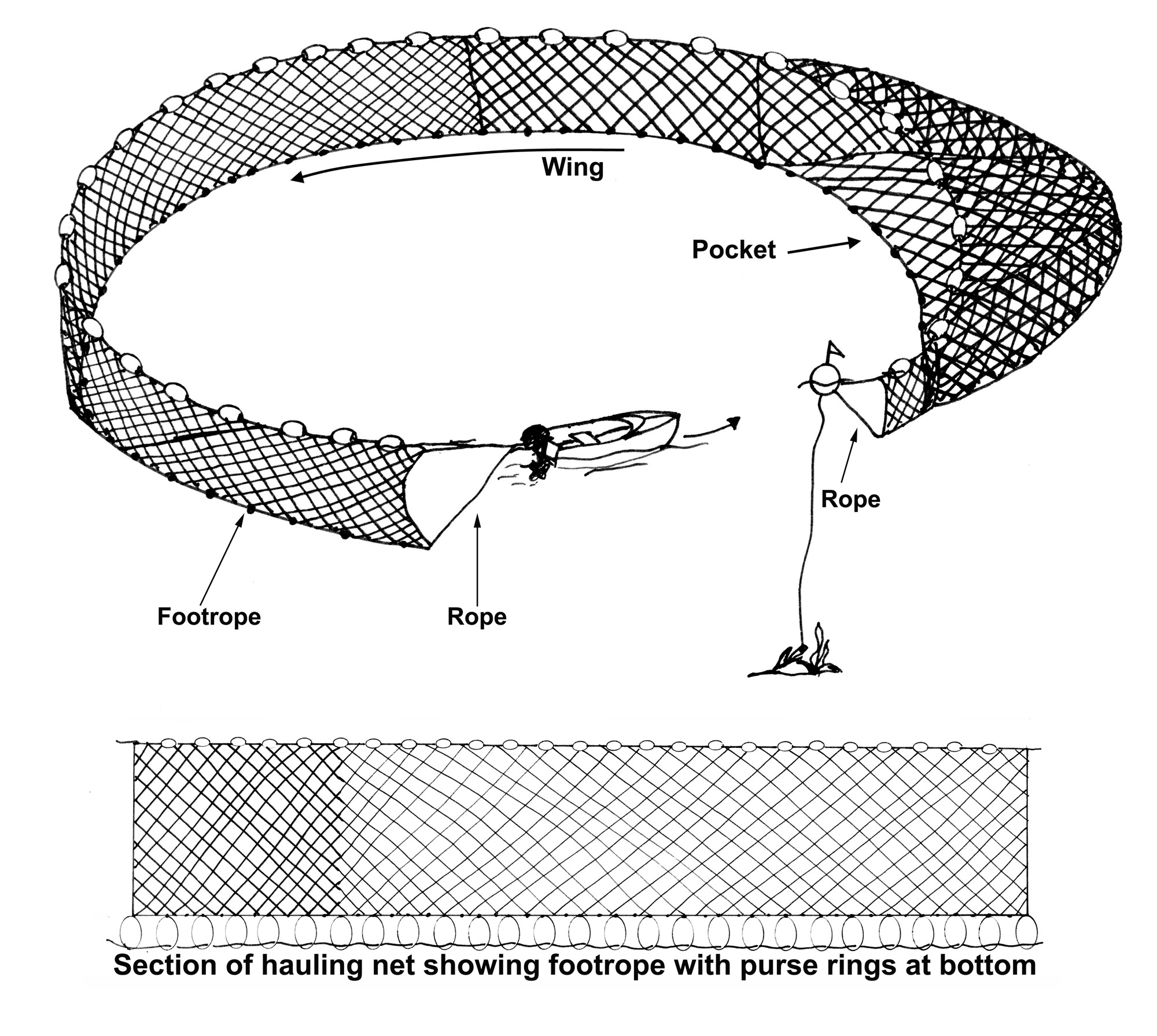
The diagram below is for convenience of reference only.
84—Use of hauling net of unlawful specifications for power hauling
The taking of fish in the waters of the State by using the power hauling
method of fishing if the hauling net used—
(a)
exceeds 600 metres in length; or
(b) has
a depth exceeding 10 metres; or
(c) has
more than 100 metres of floating rope attached to it; or
(d) does
not have attached to the bunt end—
(i)
a flag buoy that complies with regulation 13 and has
a yellow flag not less than 30 centimetres by 30 centimetres displayed from
the top so as to be visible at least 1 metre above the water; and
(ii)
if used between sunset and sunrise—a flashing white
light visible all around the bunt end for at least 1 nautical mile.
85—Use of mesh net of unlawful specifications in certain Coorong waters
The taking of fish by using a mesh net that exceeds 150 metres in length in
those waters of the Coorong within the geodesic from the location on Mean High
Water Springs closest to 35°33′09.34″ South,
138°54′01.94″ East (Point Blenkinsop) to the location on
Mean High Water Springs closest to 35°33′39.00″ South,
138°54′01.18″ East, and the geodesic from the location
on Mean High Water Springs closest to
35°35′37.12″ South,
139°01′26.52″ East (Pelican Point) to the location on
Mean High Water Springs closest to 35°35′40.55″ South,
139°00′44.59″ East (Gnurlung Point).
86—Use of mesh net of unlawful specifications in Goolwa waters
The taking of fish by using a mesh net that exceeds 150 metres in length,
on any day of any week except Saturday and Sunday in those waters of the
Coorong contained within and bounded by a line commencing at Mean High Water
Springs closest to 35°31′23.37″ South,
138°48′33.36″ East (Point Luff), then beginning
generally easterly following the line of Mean High Water Springs to the
location closest to 35°32′58.77″ South,
138°52′45.90″ East, then southerly to northern side of
the headland of Sir Richard Peninsula near
35°33′18.64″ South,
138°52′45.90″ East, then beginning north-westerly
following the line of Mean High Water Springs to the location closest to
35°31′42.81″ South,
138°48′29.11″ East, then north-easterly to the point of
commencement.
87—Use of mesh net of unlawful specifications in Lakes Albert and
Alexandrina
The taking of fish in the waters of Lakes Albert and Alexandrina by using a
mesh net that—
(a)
exceeds 550 metres in length; or
(b)
exceeds 5 metres in depth; or
(c) has
a mesh size of less than 50 millimetres.
88—Use of large mesh net of unlawful specifications
The taking of fish in the waters of the State by using a large mesh net that
exceeds 600 metres in length.
89—Use of purse seine net of unlawful specifications to take salmon
The taking of Salmon ( Arripis truttaceus ) in the waters of the State by
using a purse seine net that—
(a)
exceeds 900 metres in length; or
(b)
exceeds 13 metres in depth; or
(c) has
a mesh size of less than 50 millimetres.
90—Use of shrimp trap of unlawful specifications
The taking of fish in the waters of the State by using a shrimp trap
that—
(a)
exceeds 400 millimetres at its greatest dimension; or
(b)
exceeds 200 millimetres in height; or
(c) has
a net forming part of the trap which has a mesh of less than 5 millimetres; or
(d) has
an entrance or opening the diameter of which exceeds 30 millimetres.
Division 4—Use of unbuoyed or untagged devices
91—Use of unbuoyed mesh net or set line
The taking of fish—
(a) in
the waters of Lakes Albert and Alexandrina, the Coorong or in any contiguous
waterway downstream of Wellington by using a mesh net or set line
unless—
(i)
1 extremity of the net or line is marked by 2 black buoys
that comply with regulation 13; and
(ii)
the other extremity of the net or line is marked by a
yellow buoy that complies with regulation 13; and
(iii)
if the net or line exceeds 50 metres in length, the net
or line is marked with red buoys that comply with regulation 13 and are
placed at intervals not exceeding 50 metres; or
(b) in
any other waters of the State by using a mesh net or set line unless—
(i)
1 extremity of the net or line is marked by a yellow buoy
that complies with regulation 13; and
(ii)
the other extremity of the net or line is marked by 2
black buoys that comply with regulation 13.
92—Use of unbuoyed fish net
The taking of fish in the waters of the State by using a fish net (other than
a mesh net or drum net) unless—
(a) 1
extremity of the net is marked by a yellow buoy that complies with
regulation 13; and
(b) the
other extremity of the net is marked by 2 black buoys that comply with
regulation 13.
Division 5—Use of devices near other devices
93—Use of fish net near another fish net in
Lakes Albert and Alexandrina, Murray Mouth or Coorong
The taking of fish by using a fish net in the waters of Lakes Albert and
Alexandrina, the Murray Mouth and Coorong within 200 metres of any other fish
net.
Division 6—Use of certain devices in certain waters
94—Use of device other than rod and line, hand line or hand net in
certain waters
The taking of fish in any of the following waters by using a device other than
a rod and line, hand line or hand net:
(a) the
waters of the Onkaparinga River;
(b) the
waters of Baird Bay north of the geodesic from the location on
Mean High Water Springs closest to 33°10′33.69″ South,
134°22′11.38″ East to the location on Mean High Water
Springs closest to 33°11′26.03″ South,
134°21′04.68″ East;
(c) the
waters of or near Antechamber Bay that are within 50 metres of a line joining
the locations on Mean High Water Springs closest to
35°47′18.11″ South,
138°04′15.45″ East and
35°47′22.93″ South,
138°04′17.46″ East (mouth of the Chapman River),
together with the waters of the Chapman River;
(d) the
waters of or near Vivonne Bay that are within 50 metres of a line joining the
locations on Mean High Water Springs closest to
35°58′28.27″ South,
137°12′04.87″ East and
35°58′28.13″ South,
137°12′05.94″ East (mouth of the Eleanor River),
together with the waters of the Eleanor River;
(e) the
waters of or near Vivonne Bay that are within 50 metres of a line joining the
locations on Mean High Water Springs closest to
35°59′09.08″ South,
137°10′45.37″ East and
35°59′05.48″ South,
137°10′47.69″ East (mouth of the Harriet River),
together with the waters of the Harriet River;
(f) the
waters of or near Snelling Beach that are within 50 metres of a line joining
the locations on Mean High Water Springs closest to
35°39′55.34″ South,
137°04′28.57″ East and
35°39′54.88″ South,
137°04′28.69″ East (mouth of the Middle River), together
with the waters of the Middle River;
(g) the
waters of or near Western River Cove that are within 50 metres of a line
joining the locations on Mean High Water Springs closest to
35°40′32.77″ South,
136°58′18.71″ East and
35°40′32.68″ South,
136°58′19.07″ East (mouth of the Western River),
together with the waters of the Western River;
(h) the
waters of or near MacDonnell Bay contained within and bounded by a line
commencing at Mean High Water Springs closest to
38°03′07.22″ South,
140°42′43.45″ East, then generally southerly following a
line at a radius of 1020 metres from the intersection of the Port MacDonnell
jetty with Mean High Water Springs at the location closest to
38°03′16.35″ South,
140°42′03.32″ East to the location on Mean High Water
Springs closest to 38°03′23.77″ South,
140°41′22.62″ East, then beginning south-easterly
following the line of Mean High Water Springs to the point of commencement,
but excluding the waters of or near MacDonnell Bay contained within and
bounded by a line commencing at Mean High Water Springs closest to
38°03′11.73″ South,
140°42′26.64″ East, then generally north-easterly
following the line of Mean High Water Springs to the location closest to
38°03′07.22″ South,
140°42′43.45″ East, then generally southerly following a
line at a radius of 1020 metres from the intersection of the Port MacDonnell
jetty with Mean High Water Springs at the location closest to
38°03′16.35″ South,
140°42′03.32″ East to a line 300 metres seaward of Mean
High Water Springs closest to 38°03′16.83″ South,
140°42′45.08″ East, then generally south-westerly
following a line 300 metres seaward of Mean High Water Springs to the location
closest to 38°03′01.33″ South,
140°42′28.36″ East, then north-westerly to the point of
commencement.
95—Use of certain devices in inland waters
(1) The taking of fish
using a fyke net in the waters to which this clause applies other than the
taking of short finned eel ( Anguilla australis occidentalis ) using a
fyke net that—
(a) is
not more than 1.5 metres in height, length and width; and
(b) has
entrance funnels that do not exceed 6 centimetres at their narrowest
part; and
(c) has
mesh that—
(i)
if made of fish netting—is of at least
3 centimetres; or
(ii)
if made of mesh material (whether rigid or
flexible)—is such as to allow a cylindrical rod 9 millimetres in
diameter to be passed freely through it.
(2) This clause
applies to inland waters within the counties of MacDonnell, Robe and Grey,
excluding the waters of Lake George.
96—Use of towed net in certain waters
The taking of fish (other than prawn and other than by the power hauling
method of fishing) in any of the following waters by the use of a net being
towed behind a moving boat or by the hauling of a net through the water by
means other than by hand from a boat:
(a) the
waters of Spencer Gulf less than 40 metres in depth;
(b) the
waters of Gulf St. Vincent north of the geodesic from the location on
Mean High Water Springs closest to 35°10′04.69″ South,
137°40′38.66″ East (Troubridge Point, Yorke Peninsula)
to the location on Mean High Water Springs closest to
35°36′48.46″ South,
138°05′44.04″ East (Cape Jervis, Fleurieu Peninsula);
(c) all
the waters of the State less than 20 metres in depth.
97—Use of fish net in certain waters
The taking of fish by using a fish net in any of the waters of the ocean and
bays and gulfs of the State between the meridians of longitude 129° East
and 140°58′00″ East at a depth exceeding 5 metres other
than—
(a) the
taking of fish by a large mesh net; or
(b) the
taking of salmon ( Arripis truttaceus ) by a licensed person by using a
fish net; or
(c) the
taking of fish by a licensed person by using a bait net for the purpose of
bait to be used for the taking of rock lobster in the waters of the fishery in
respect of which he or she holds a licence.
98—Use of fish net in Spencer Gulf
The taking of fish by using a fish net—
(a) in
the waters of Spencer Gulf north of the geodesic from the location on
Mean High Water Springs closest to 32°48′30.29″ South,
137°48′12.75″ East to the location on Mean High Water
Springs closest to 32°48′30.29″ South,
137°54′11.81″ East, passing through marine navigation
mark 4510/800 near 32°48′30.29″ South,
137°49′30.06″ East; or
(b) in
the waters of Spencer Gulf commencing at the 5 metres mark near Gibbon
Point (longitude 136°47.00′ East), then easterly along
latitude 33°50.00′ South to intersect longitude
137°14.00′ East, then northerly to the 5 metres mark near
Shoal Water Light; or
(c) in
the waters of Spencer Gulf deeper than 5 metres and contained within and
bounded by a line commencing at Mean High Water Springs closest to
33°37′59.88″ South,
137°13′59.98″ East, then southerly to
33°49′59.83″ South,
137°13′59.99″ East, then westerly to the location on
Mean High Water Springs closest to 33°49′46.96″ South,
136°46′44.77″ East (Gibbon Point), then beginning
north-easterly following the line of Mean High Water Springs to the point of
commencement, other than—
(i)
the taking of fish by any person by using a
large mesh net; or
(ii)
the taking of salmon ( Arripis truttaceus ) by a
licensed person by using a fish net.
99—Use of fish net or set line in certain waters
The taking of fish by using a fish net or set line in those waters of the
Coorong contained within and bounded by a line commencing at Mean High Water
Springs closest to 35°32′58.77″ South,
138°52′45.90″ East, then generally easterly following
the line of Mean High Water Springs to the location closest to
35°32′59.50″ South,
138°53′52.30″ East, then south-easterly to the location
on Mean High Water Springs closest to
35°33′09.34″ South,
138°54′01.94″ East (Point Blenkinsop), then southerly to
the location on Mean High Water Springs closest to
35°33′39.00″ South,
138°54′01.94″ East, then beginning north-easterly
following the line of Mean High Water Springs to the mouth of the River Murray
on the northern side of the headland of Younghusband Peninsula near
35°33′21.90″ South,
138°52′53.37″ East, then across the mouth of the River
Murray to the northern side of the headland of Sir Richard Peninsula near
35°33′18.64″ South,
138°52′45.90″ East, then northerly to the point of
commencement.
100—Use of long line in Murray Mouth
The taking of fish in the Murray Mouth by using a long line.
101—Use of mesh net as set net in Murray Lakes, Murray Mouth and Coorong
The taking of fish by using a mesh net as a set net in the waters within 150
metres of each side of the Goolwa, Mundoo, Boundary Creek, Ewe Island and
Tauwitchere Barrages.
102—Use of mesh net as set net on weekends in certain waters
The taking of fish by using a mesh net as a set net during the period
commencing at midnight on Friday and ending at sunset on the following Sunday
in those waters of the Coorong contained within and bounded by a line
commencing at Mean High Water Springs closest to
35°31′23.37″ South,
138°48′33.36″ East (Point Luff), then beginning
generally easterly following the line of Mean High Water Springs to the
location closest to 35°32′58.77″ South,
138°52′45.90″ East, then southerly to the northern side
of the headland of Sir Richard Peninsula near
35°33′18.64″ South,
138°52′45.90″ East, then beginning north-westerly
following the line of Mean High Water Springs to the location closest to
35°31′42.81″ South,
138°48′29.11″ East, then north-easterly to the point of
commencement.
103—Use of hauling net on weekends in certain waters
The taking of fish by using a hauling net during the period commencing at
midnight on Friday and ending at sunset on the following Sunday in that part
of the waters described in clause 102 that is usually marked by beacons
and commonly known as the "boating channel".
104—Use of certain devices near artificial reefs
(1) The taking of fish
using a fish net, fish trap, hand fish spear, speargun or long line within 0.5
of a nautical mile from any of the artificial reefs specified in the table
below.
|
Location |
Artificial reef |
Latitude (South) |
Longitude (East) |
|
Ardrossan |
Dredge |
34°31′47.95″ |
138°03′36.02″ |
|
Giles Point |
Tyre module |
35°02′59.95″ |
137°47′24.00″ |
|
Glenelg |
Dredge |
34°58′47.95″ |
138°26′24.04″ |
|
Glenelg |
Sunken barge |
34°58′47.95″ |
138°26′24.04″ |
|
Glenelg |
Tyre module |
34°58′47.95″ |
138°26′24.04″ |
|
Grange |
Tyre module |
34°55′11.94″ |
138°24′00.01″ |
|
Kingscote, Kangaroo Island |
Tyre module |
35°41′23.95″ |
137°40′12.02″ |
|
Port Augusta |
Tyre module |
32°40′11.94″ |
137°45′36.01″ |
|
Port Broughton |
Car bodies |
33°32′59.95″ |
137°51′36.03″ |
|
Port Germein |
Pipes |
33°03′35.95″ |
138°00′00.03″ |
|
Port Lincoln |
Sunken vessel |
34°40′47.95″ |
135°52′12.01″ |
|
Port Neill |
Sunken vessel |
34°06′35.95″ |
136°22′48.05″ |
|
Port Noarlunga |
Tyre module |
35°08′59.96″ |
138°26′24.04″ |
|
Port Pirie |
Tyre module |
33°05′23.95″ |
137°54′36.04″ |
|
Streaky Bay |
Tyre module |
32°43′55.42″ |
134°14′48.80″ |
|
Wallaroo |
Tyre module |
33°51′35.95″ |
137°34′12.06″ |
|
Whyalla |
Tyre module |
32°58′11.95″ |
137°46′48.03″ |
|
Whyalla |
Tyre module |
32°59′59.95″ |
137°47′24.01″ |
|
Whyalla |
Tyre module |
33°06′35.95″ |
137°36′36.03″ |
(2) The taking of fish
by any person within 930 metres from the artificial reef known as
Fleurieu Reef, 35°28′08.95″ South,
138°09′05.03″ East.
105—Use of device for more than 4 hours
The taking of fish in the waters of the State by using a large mesh net that
has been left in the water for a period of more than 4 consecutive hours.
Division 7—Use of certain fishing methods
106—Taking of prawn by power hauling method
The taking of prawn in the waters of the State by using the power hauling
method of fishing.
107—Taking fish in Gulf St. Vincent or Spencer Gulf using
large mesh net
The taking of fish in the waters of Gulf St. Vincent or Spencer Gulf by using
a large mesh net that has not been shot out in a straight line.
108—Taking fish by using fish net fixed etc across bay
The taking of fish by using a fish net that has been fixed, set or staked
across any bay, inlet, river, creek or tidal water or the greater part of any
bay, inlet, river, creek or tidal water.
109—Taking of fish by placing stake etc across mouth of waters
The taking of fish by fixing or placing any stake, log, stone or other article
or thing, other than a fish net, across—
(a) the
whole or any part of the mouth of any waters; or
(b) the
whole or any part of any channel, creek, stream, river or tidal waters,
in such a manner as is likely to impair the free passage of fish in those
waters.
110—Taking of fish using pipeline
The taking of fish by using a pipeline through which water is pumped from any
waters of the State.
111—Taking of fish using explosives or certain substances
The taking of fish in the waters of the State by—
(a) the
explosion of any substance (other than by use of a spear gun); or
(b) the
use of any anaesthetic, narcotic or poisonous substance.
Division 8—Bag and boat limits
112—Bag limit on rock lobster taken by diving
The taking in any 1 day of more than 4 rock lobster by diving in the waters
of the State.
Division 9—Miscellaneous
113—Taking of undersize or oversize fish
(1) The taking, in the
waters of the State, of—
(a)
undersize fish; or
(b)
Western Blue Groper or Murray Cod that exceeds 100 centimetres in length.
(2) The taking, in
coastal waters, of Wrasse (Family Labridae) (other than Western Blue Groper)
that is less than 25 centimetres in length or more than
35 centimetres in length.
114—Taking of molluscs in West Lakes and adjacent foreshore area
The taking of molluscs in the waters of West Lakes, and foreshore areas
adjacent to those waters, including reserves for public use.
115—Taking of certain shellfish in Port Adelaide River
The taking of filter-feeding marine molluscan shellfish in the waters of the
Port Adelaide River between Bower Road, Semaphore Park and the junction of
Lipson Reach and North Arm, Port Adelaide.
116—Taking of benthic marine organisms in certain waters
The taking of a benthic marine organism in waters seaward of the line of
Mean High Water Springs to a depth of 2 metres in the area of a rocky reef and
its waters—
(a)
adjacent to the State; or
(b)
adjacent to an off-shore island forming part of the State.
117—Taking of prawn in certain waters less than 10 metres deep
The taking of prawn in any waters of the ocean and the bays and gulfs of the
State between meridians of longitude 129° East and
140°58′00″ East less than 10 metres in depth at the low water
mark.
118—Taking of rock lobster in certain waters
The taking of rock lobster in any of the following waters:
(a) the
waters of or near Cape Jaffa contained within and bounded by a line commencing
at the intersection of the jetty with Mean High Water Springs near
36°56′29.84″ South,
139°41′17.71″ East, then beginning westerly following
the line of Mean High Water Springs to the location closest to
36°57′03.30″ South,
139°40′22.43″ East, then westerly to a line 1000 metres
seaward of Mean High Water Springs closest to
36°57′03.30″ South,
139°39′36.35″ East, then beginning north-easterly
following a line 1000 metres seaward of Mean High Water Springs to the
location closest to 36°55′56.83″ South,
139°41′17.80″ East, then southerly to the northern end
of the jetty near 36°56′23.83″ South,
139°41′17.80″ East, then south along the jetty to the
point of commencement; or
(b) the
waters within 1000 metres of marine navigation mark number 4860/100 (Margaret
Brock Reef) at 36°57′06.49″ South,
139°35′42.57″ East; or
(c) the
waters of or near Rivoli Bay contained within and bounded by a line commencing
at Mean High Water Springs closest to
37°29′32.52″ South,
140°00′42.20″ East, then north-easterly following the
line of Mean High Water Springs to the location closest to
37°29′24.54″ South,
140°00′57.61″ East (Glen Point), then southerly to a
line 100 metres seaward of Mean High Water Springs (Penguin Island) closest to
37°29′56.21″ South,
140°00′57.19″ East, then beginning southerly following a
line 100 metres seaward of Mean High Water Springs (Penguin Island) to the
location closest to 37°29′51.19″ South,
140°00′42.25″ East, then northerly to the location on
Mean High Water Springs closest to 37°29′45.91″ South,
140°00′42.25″ East, then generally northerly following
the line of Mean High Water Springs to the location closest to
37°29′37.41″ South,
140°00′42.20″ East, then northerly to the point of
commencement; or
(d) the
waters of or near Point Annie contained within and bounded by a line
commencing at Mean High Water Springs closest to
34°57′09.34″ South,
136°58′23.59″ East (Point Annie), then beginning
south-easterly following the line of Mean High Water Springs to the location
closest to 35°00′46.17″ South,
136°56′38.33″ East, then north-easterly to the location
on Mean High Water Springs closest to
34°57′57.77″ South,
136°57′21.73″ East, then north-easterly to the point of
commencement.
119—Taking of fish near locks and weir of River Murray proper
The taking of fish in waters within 150 metres of each side of each lock and
weir of the River Murray proper.
120—Taking of certain fish during closed season
The taking of fish of a class specified in column 1 of the table below in the
waters specified alongside in column 2 during the period specified alongside
in column 3.
|
Column 1 Class of fish |
Column 2 Waters |
Column 3 Closed season |
|---|---|---|
|
Molluscs | | |
|
Razorfish ( Pinna bicolor ) |
The waters of Spencer Gulf contained within and bounded by a line commencing
at Mean High Water Springs closest to
32°32′29.34″ South,
137°45′10.65″ East, then easterly to
32°32′29.34″ South,
137°46′42.99″ East (marine navigation mark 4510/028),
then south-westerly to 32°32′55.76″ South,
137°46′36.16″ East (marine navigation mark 4510/825),
then south-westerly to 32°33′32.22″ South,
137°46′12.91″ East (marine navigation mark 4510/821),
then south-westerly to 32°34′01.88″ South,
137°45′54.46″ East (marine navigation mark 4510/817),
then south-easterly to 32°35′06.43″ South,
137°46′07.62″ East (marine navigation mark 4510/020),
then south-easterly to 32°36′25.52″ South,
137°46′23.71″ East (marine navigation mark 4510/013),
then south-westerly to 32°38′59.40″ South,
137°46′13.80″ East (marine navigation mark 4510/009),
then south-easterly to 32°41′20.14″ South,
137°46′46.29″ East (marine navigation mark 4510/808),
then westerly to the location on Mean High Water Springs closest to
32°41′20.14″ South,
137°45′20.28″ East, then generally northerly following
the line of Mean High Water Springs to the point of commencement. |
The period commencing on 1 January in any year and ending on the last day
of the following February. The period commencing on 1 October in any year and ending on the
following 31 December. |
|
Scalefish | | |
|
Bream ( Acanthopagrus spp) |
The waters of Onkaparinga River upstream from the bridge on Main South Road at
Noarlunga (D V Fleming Bridge) near 35°10′33.15″ South,
138°29′55.34″ East. |
The period commencing on 1 September in any year and ending on the
following 30 November. |
121—Taking fish using wire trace of unlawful gauge with certain hooks
The taking of fish in the waters of the State by using wire trace of
2 millimetres or greater gauge in conjunction with fishing hooks size
12/0 or greater.
123—Setting of rock lobster pots containing rock lobster
The setting in the waters of the State, for a purpose other than a commercial
purpose, of a rock lobster pot that contains rock lobster.
124—Use of registered boat other than under fishery authority
(1) The taking of fish
in the waters of the State by using a registered boat other than the taking of
fish under a fishery authority.
(2) Subclause (1)
does not apply if—
(a) the
Department has been notified in the manner and form, and at such time, as
determined by the Minister, of the intended use of a registered boat to take
fish other than under a fishery authority; or
(b) the
boat is registered for use under a licence in respect of the
Charter Boat Fishery and the boat is to be used by unlicensed persons for
recreational fishing.
125—Taking of cephalopods in False Bay (Spencer Gulf)
The taking of a mollusc of the class Cephalopoda in the following waters:
The waters of or near False Bay contained within and bounded by a line
commencing at Mean High Water Springs closest to
33°02′10.14″ South,
137°35′49.30″ East, then beginning north-westerly
following the line of Mean High Water Springs to the location closest to
33°00′00.70″ South,
137°47′08.74″ East (near Point Lowly Lighthouse), then
south-westerly to the southern end of the jetty at Port Bonython at the
location closest to 33°00′48.20″ South,
137°45′55.31″ East, then south-westerly to the south
eastern end of the BHP jetty at the location closest to
33°02′11.59″ South,
137°35′56.64″ East, then north-westerly along the said
jetty to the point of commencement, but excluding any land or waters so
encompassed that lie landward of the line of Mean High Water Springs.
126—Taking fish using certain traces or hooks in certain waters
(1) The taking of fish
between 0500 and 2100 hours on any day using—
(a) wire
trace; or
(b)
monofilament trace exceeding 1 millimetre in diameter; or
(c) a
fishing hook size exceeding 56 millimetres in length; or
(d) a
fishing hook with a gape exceeding 23 millimetres; or
(e) a
combination or gang of hooks that are joined by threading the point of 1
through the eye of another,
in the waters and adjacent foreshore areas contained within the area from the
southern Outer Harbor breakwater (34°46′58.95″ South,
138°28′40.48″ East), to Lady Bay Shacks, south of Normanville
(35°28′30.77″ South,
138°17′05.29″ East) from Mean High Water Springs to a
distance of 500 metres seaward.
(2) In this
clause—
gape of a fishing hook means the distance from the tip of the point of the
hook to the inside of the shaft.
127—Taking fish near Horseshoe Reef
The taking of fish from within 25 metres of any part of Horseshoe Reef
(35°08′14.55″ South,
138°27′49.13″ East) that becomes exposed at low water.
128—Taking fish in certain parts of Onkaparinga River
The taking of fish (other than the taking of fish by using a hand line or
rod and line or the taking of shrimp (Suborder Natantia) by using a shrimp
net)—
(a)
upstream from the mouth of the Onkaparinga River at a point closest to
35°09′53.21″ South,
138°28′13.54″ East, to the bridge on Main South Road at
Noarlunga (D V Fleming Bridge) closest to
35°10′33.31″ South,
138°29′55.88″ East; or
(b) in
that portion of the waters of the estuary from the mouth of the Onkaparinga
River at a point closest to 35°09′53.21″ South,
138°28′13.54″ East, to the bridge on Main South Road at
Noarlunga (D V Fleming Bridge) closest to
35°10′33.31″ South,
138°29′55.88″ East.