 South Australian Current Regulations
 South Australian Current Regulations
Part 1—Identification of
restricted areas
1—Identification of restricted areas
Editorial note—
Unless the contrary intention appears, the maps in this Schedule are provided
for convenience of reference only.
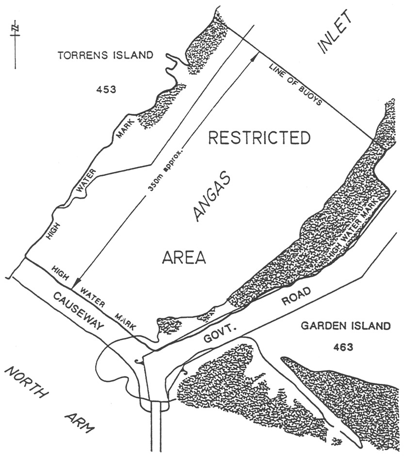
Angas Inlet
The portion of Angas Inlet that is bounded as follows:
commencing at a point where Median High Water Mark on Torrens Island
intersects the line of buoys, then south-east along the line of buoys to a
point where median high water on Garden Island intersects the line of buoys,
then south-west along Median High Water Mark to the Causeway, then north-west
along Median High Water Mark to Torrens Island, then north-east along the
Median High Water Mark to the point of commencement.
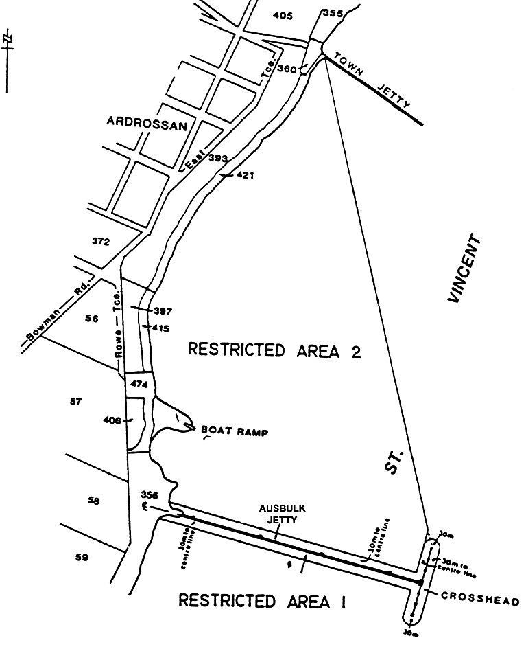
Ardrossan
Area 1 : the area of the sea at Ardrossan extending for 30 m north and
south of the Ausbulk Jetty centre line and its production westerly, 30 m
east and west of the Ausbulk Jetty crosshead centre line, and 30 m from
the intersections of that centre line with the north and south ends of the
Ausbulk Jetty crosshead.
Area 2 : the area of the sea at Ardrossan bounded as follows:
• on the east by
a straight line commencing at the intersection of the south-west side of the
town jetty and the High Water Mark and drawn in a south-easterly direction
toward the north-east corner of the Ausbulk Jetty crosshead: to a point where
it intersects with a straight line 30 m west of and parallel to the
Ausbulk Jetty crosshead centre line and its production northerly;
• on the south
by a straight line 30 m north and parallel to the Ausbulk Jetty centre
line and its production westerly;
• on the west
and north-west by the High Water Mark.
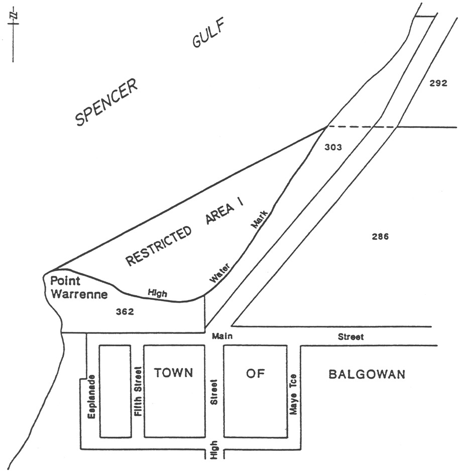
Balgowan
Area 1 : the portion of the sea at Balgowan bounded as follows:
• on the
north-west by a straight line joining Point Warrenne with a point being the
intersection of the High Water Mark and the prolongation seaward of the
northern boundary of Section 286, Hundred of Kilkerran;
• on the south
and east by the High Water Mark.
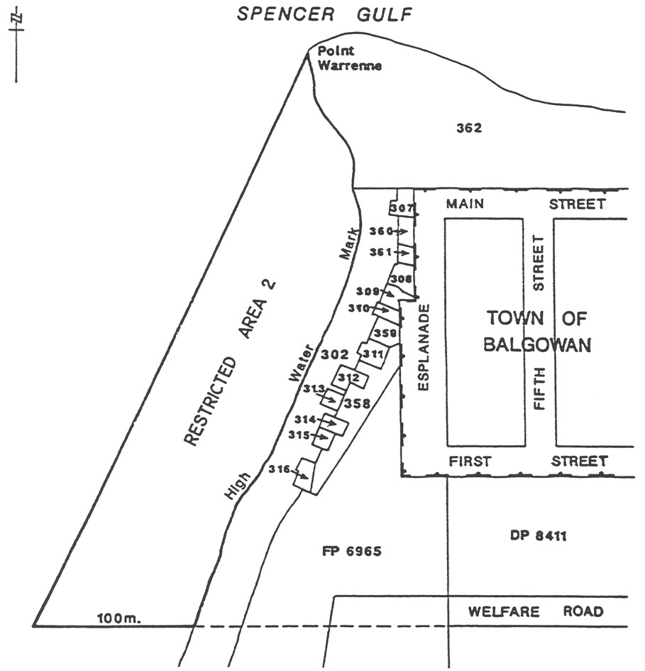
Area 2 : the portion of the sea at Balgowan bounded as follows:
• on the west by
a straight line joining Point Warrenne with a point being 100 m west of
the High Water Mark on the prolongation seaward of the southern boundary of
Welfare Road, Township of Balgowan, Hundred of Kilkerran;
• on the south
by a straight line commencing at the High Water Mark and extending seaward for
100 m along the prolongation of the southern boundary of Welfare Road,
Township of Balgowan, Hundred of Kilkerran;
• on the east by
the High Water Mark.
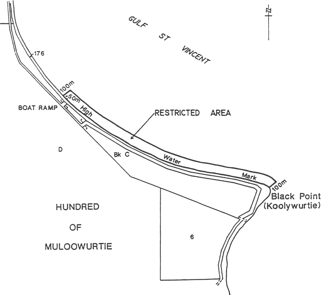
Black Point
The portion of the sea at Black Point bounded as follows:
• on the
north-west by a straight line commencing 50 m north-west of the boat ramp
and extending seaward (north-easterly) for 100 m from the High Water
Mark;
• on the
south-east by a straight line parallel to the north-east boundary and
extending 100 m seaward from the High Water Mark at Black Point;
• on the
north-east by a straight line 100 m from, and parallel to, the High Water
Mark, and joining the seaward extremities of the north-west and south-east
boundaries;
• on the
south-west by the High Water Mark.
Blackfellows' Caves
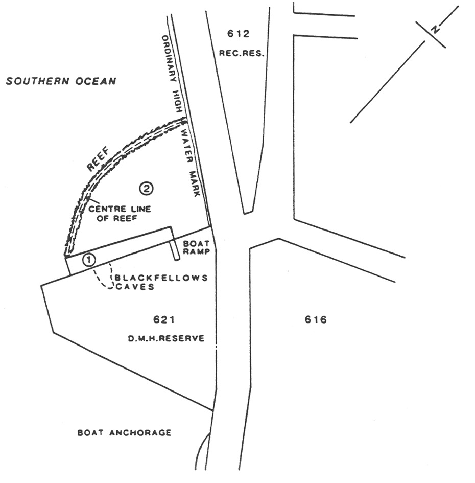
Area 1 : the portion of the sea at Blackfellows' Caves bounded as follows:
• on the
south-east by the north-west boundary of section 621, Hundred of
Kongorong;
• on the
north-east by a straight line being the prolongation north-westerly of the
north-east edge of the boat ramp for a distance of 10 m seawards from the
aforesaid south-east boundary;
• on the
south-west by a straight line extending south-easterly from the south
extremity of the centre line of the reef to intersect the aforesaid south-east
boundary at right angles;
• on the
north-west by a straight line joining the north-west extremities of the
aforesaid south-west and north-east boundaries.
Area 2 : the portion of the sea at Blackfellows' Caves bounded as follows:
• on the
south-west, west and north-west by the centre line of the reef;
• on the
north-east by the High Water Mark;
• on the
south-east by the north-west and north-east boundaries of Area 1 and the
north-west boundary of Section 621, Hundred of Kongorong.
Blanchetown
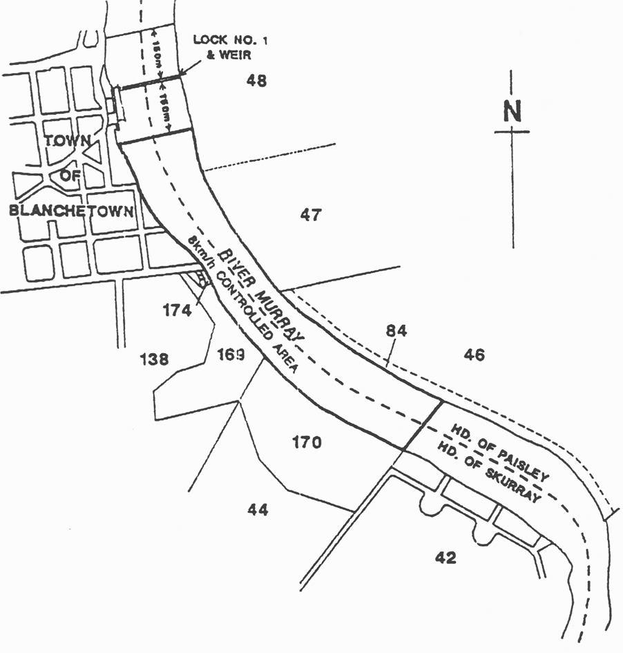
Area 1 : The portion of the River Murray at Blanchetown delineated in bold on
the plan below:
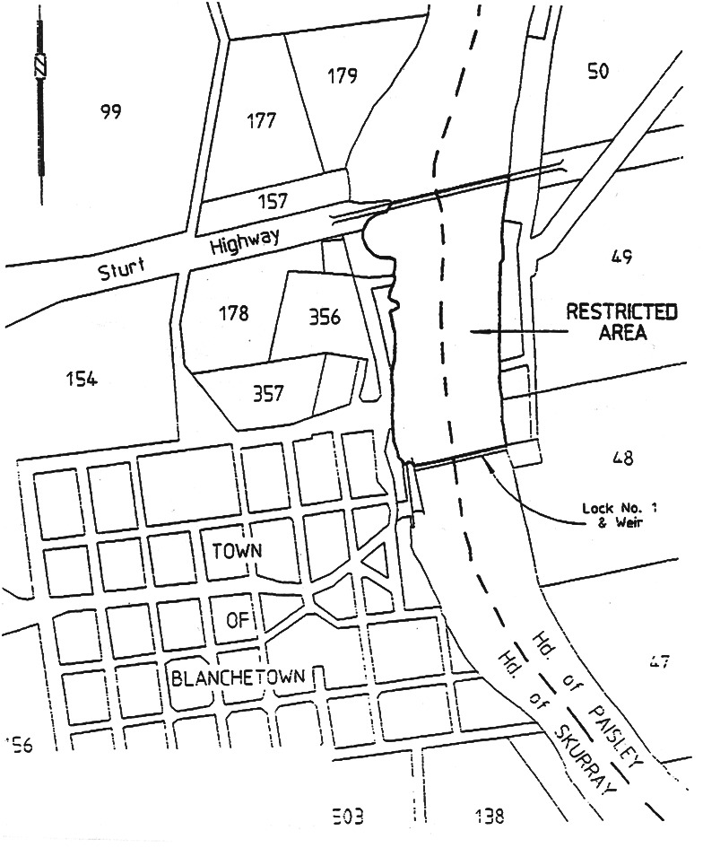
Area 2 : the portion of the River Murray at Blanchetown bounded as follows:
• on the north
by the northern alignment of the Sturt Highway road bridge;
• on the south
by the northern alignment of Lock No 1;
• on the east
and west by the river edge.
Brighton
Area 1 : the portion of the waters of Gulf St. Vincent bounded as
follows:
• on the north
by a straight line being the north boundary of the City of Brighton adjoining
the sea coast and its production seaward;
• on the south
by a straight line being the production seaward of the north alignment of
Whyte Street;
• on the east by
the High Water Mark;
• on the west by
a line approximately 100 m seaward of and parallel to the Low Water Mark.
Area 2 : the portion of the waters of Gulf St. Vincent bounded as follows:
• on the north
by a straight line being the production seaward of the south alignment of
Harrow Road;
• on the south
by a straight line extending seaward of the High Water Mark and being
200 m north of and parallel to the north alignment of Gladstone Road;
• on the east by
the High Water Mark;
• on the west by
a line approximately 100 m seaward of and parallel to the Low Water Mark.
Area 3 : the portion of the waters of Gulf St. Vincent bounded as
follows:
• on the north
by a straight line being the production seaward of the south alignment of
Downing Street;
• on the south
by a straight line being the production seaward of the south alignment of
Cambridge Terrace;
• on the east by
the High Water Mark;
• on the west by
a line approximately 100 m seaward of and parallel to the Low Water Mark.
Area 4 : the portion of the waters of Gulf St. Vincent bounded as follows:
• on the north
by a straight line being the production seaward of the north alignment of
Oleander Street;
• on the south
by a straight line extending seaward of the High Water Mark and being
200 m north of the centre of the boat ramp at Maitland Terrace and
parallel to the north alignment of Maitland Terrace;
• on the east by
the High Water Mark;
• on the west by
a line approximately 100 m seaward of and parallel to the Low Water Mark.
Area 5 : the portion of the waters of Gulf St. Vincent bounded as
follows:
• on the north
by a straight line extending seaward form the south extremity of the Seacliff
Surf Life Saving Club building;
• on the south
by a straight line, being the south boundary of the City of Brighton adjoining
the sea coast, and its production seaward;
• on the east by
the High Water Mark;
• on the west by
a line approximately 100 m seaward of and parallel to the Low Water Mark.
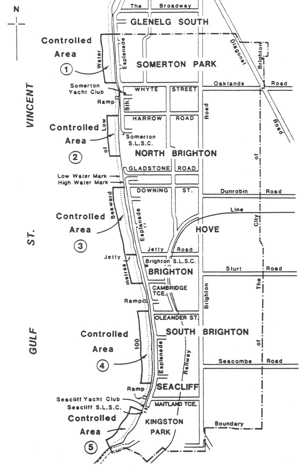
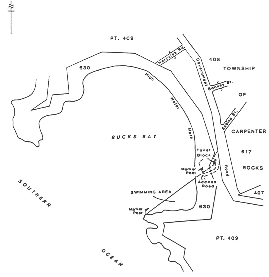
Bucks Bay
The portion of the sea at Bucks Bay bounded as follows:
• on the
north-west by a straight line joining the south-east corner of the toilet
block adjacent to the southern access road to the beach and the north-west
extremity of the promontory forming the southern limit of the bay, the line
being further defined by 2 yellow marker posts, the first post on the
northern side of the junction of the access road with the beach, the second
post being on the north-west extremity of the promontory;
• on the south
and east by the High Water Mark.
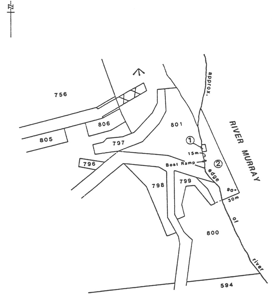
Caloote Landing
Area 1 : the portion of the River Murray near Caloote Landing bounded as
follows:
• on the west by
the river edge;
• on the north,
east and south by lines of spherical marker buoys being flame orange in
colour, the south boundary being a distance of 15 m north of the boat
ramp.
Area 2 : the portion of the River Murray near Caloote Landing bounded as
follows:
• on the south
by a straight line being the prolongation easterly of the most southerly
boundary of Section 799, Hundred of Finniss for a distance of 30 m
easterly from the river edge;
• on the east by
a straight line at right angles to the aforesaid south boundary commencing at
its east extremity and extending to intersect the river edge;
• on the west by
the river edge.
Christies Beach
The portion of the waters of Gulf St. Vincent bounded as follows:
(a) on
the north by a line parallel to and 430 m north of the prolongation in a
straight line of the northern boundary of Margaret Street, Christies Beach;
(b) on
the south by a line parallel to and 230 m north of the prolongation in a
straight line of the northern boundary of Margaret Street, Christies Beach;
(c) on
the west by a line parallel to and 650 m west of the High Water Mark;
(d) on
the east by the High Water Mark.

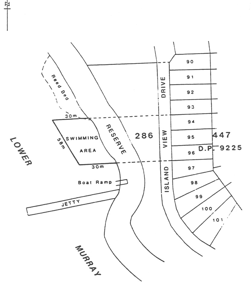
Clayton Bay
The portion of the lower River Murray at Clayton bounded as follows:
• on the north
by a straight line, marked by flame orange spherical buoys, being the
prolongation westerly of the north boundary of Lot 94 in Deposited Plan
No 9225 Section 447, Hundred of Alexandrina for a distance of
30 m westerly from the edge of the water;
• on the south
by a straight line, marked by flame orange spherical buoys, being the
prolongation westerly of the north boundary of Lot 97 in Deposited Plan
No 9225 Section 447, Hundred of Alexandrina for a distance of
30 m westerly from the edge of the water;
• on the
south-west by a straight line joining the west extremities of the aforesaid
north and south boundaries;
• on the
north-east by the edge of the water.
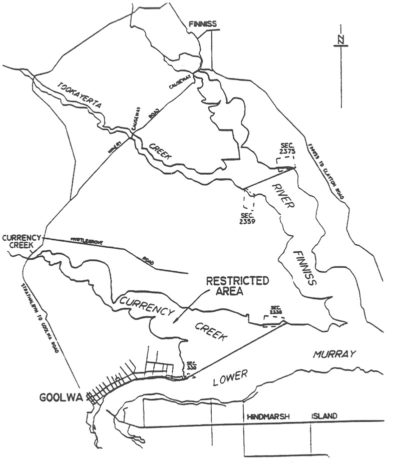
Currency Creek
All the waters of Currency Creek bounded as follows:
• on the west by
the causeway on the Goolwa to Strathalbyn Road;
• on the
south-east by a line joining the south-west corner of Section 330,
Hundred of Goolwa to the south-east corner of Section 2338, Hundred of
Nangkita.
East Wellington
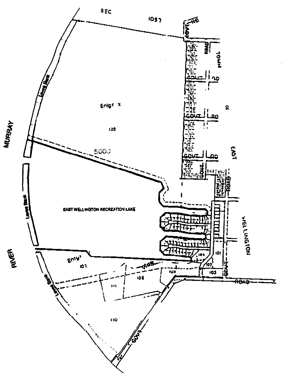
The portion of the East Wellington Recreation Lake delineated in bold on the
plan below:
Fisherman Bay
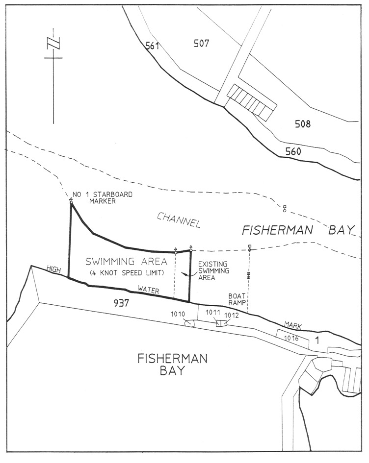
The portion of the waters of Fisherman Bay delineated in bold on the plan
below:
Fleurieu Reef
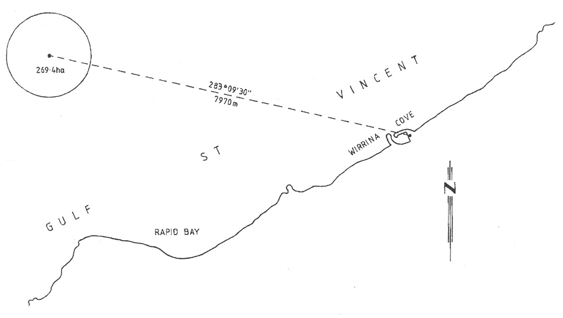
The portion of the waters of Gulf St. Vincent off the coast of Wirrina
Cove bounded by a circle of radius 0.5 of a nautical mile centred on a
point at latitude 35° 28.9′ South,
longitude 138° 09.5′ East.
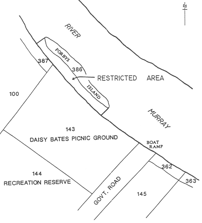
Forbys Island
The portion of the River Murray (near Loxton) between Forbys Island and the
south-west edge of the river, marked by flame orange spherical buoys.
Glenelg
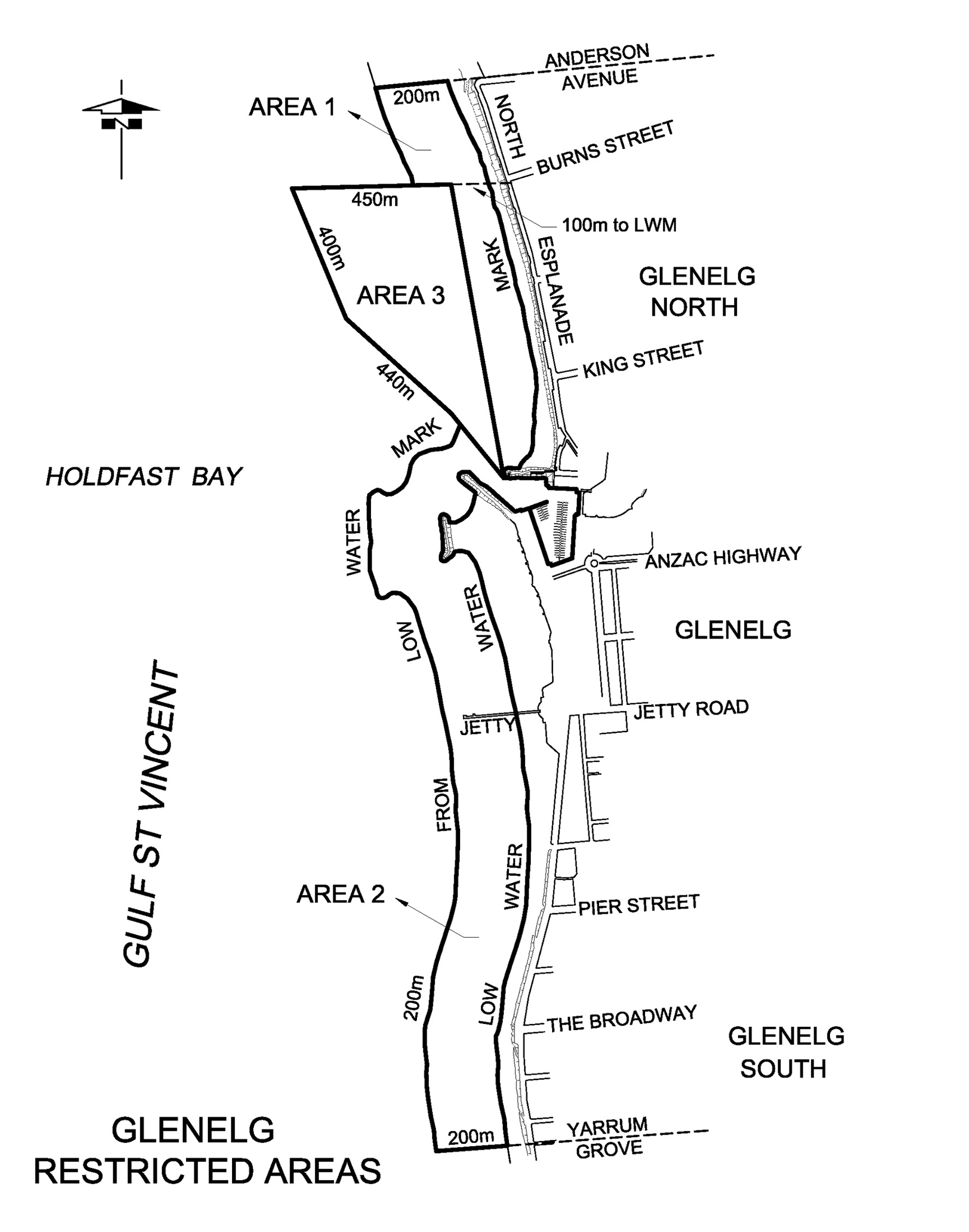
Area 1: the portion of the waters of Gulf St. Vincent at Glenelg
bounded as follows:
• commencing at
a point being the production seaward of the northern alignment of Anderson
Avenue, Glenelg North, for a distance of 200 m from the Low Water Mark;
• then generally
southerly along a line 200 m from and parallel to the Low Water Mark to
the intersection of a line between the St. Andrews Cross navigational
marker at latitude 34°58′01.08″ South, longitude
138°30′28.92″ East and the West Cardinal navigational marker
at latitude 34°58′01.08″ South, longitude
138°30′11.28″ East;
• then generally
easterly along that line to the St. Andrews Cross navigational marker;
• then generally
southerly to the Port hand navigational marker at latitude
34°58′28.11″ South, longitude 138°30′33.94″
East;
• then generally
easterly to the intersection of the Low Water Mark on the northern breakwater;
• then generally
northerly along the Low Water Mark to the production of the northern alignment
of Anderson Avenue;
• then generally
westerly to the point of commencement.
Area 2: the portion of the waters of Gulf St. Vincent at Glenelg
bounded as follows:
• commencing at
a point being the production seaward of the northern alignment of Yarrum
Grove, Glenelg South, for a distance of 200 m from the Low Water Mark;
• then generally
northerly along a line 200 m from and parallel to the Low Water Mark to
the Port hand navigational marker at latitude 34°58′22.07″
South, longitude 138°30′28.30″ East;
• then generally
south-easterly to the Port hand navigational marker at latitude
34°58′28.11″ South, longitude 138°30′33.94″
East;
• then generally
easterly to the intersection of the Low Water Mark on the northern breakwater;
• then generally
easterly, southerly and north-westerly along the Low Water Mark around the
Holdfast Shores Marina and the southern breakwater;
• then generally
southerly along the Low Water Mark to the production of the northern alignment
of Yarrum Grove;
• then generally
westerly to the point of commencement.
Area 3: the portion of the waters of Gulf St. Vincent at Glenelg
bounded as follows:
• commencing on
the north approximately 150 m from the High Water Mark of the coast to
the St. Andrews Cross navigational marker at latitude
34°58′01.08″ South , longitude 138°30′28.92″
East and extending seaward in a westerly direction for approximately
450 m to the West Cardinal navigational marker at latitude
34°58′01.08″ South, longitude
138°30′11.28″ East;
• on the west by
a straight line drawn in a generally southerly direction from latitude
34°58′01.08″ South, longitude
138°30′11.28″ East, to the West Cardinal navigational marker
at latitude 34°58′13.14″ South, longitude
138°30′16.92″ East, then south-easterly to the Port hand
navigational marker at latitude 34°58′22.07″ South,
longitude 138°30′28.30″ East;
• then
continuing from latitude 34°58′22.07″ South, longitude
138°30′28.30″ East in a south-easterly direction to the Port
hand navigational marker at latitude 34°58′28.11″ South,
longitude 138°30′33.94″ East;
• on the east by
a straight line drawn in a generally northerly direction and approximately
parallel to the shore from latitude 34°58′28.11″ South,
longitude 138°30′33.94″ East to the point of
commencement at the St. Andrews Cross navigational marker at latitude
34°58′01.08″ South, longitude
138°30′28.92″ East.
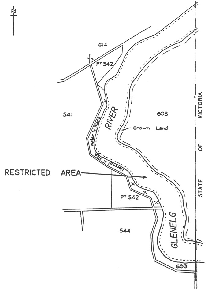
Glenelg River
All the waters of the Glenelg River within the State.
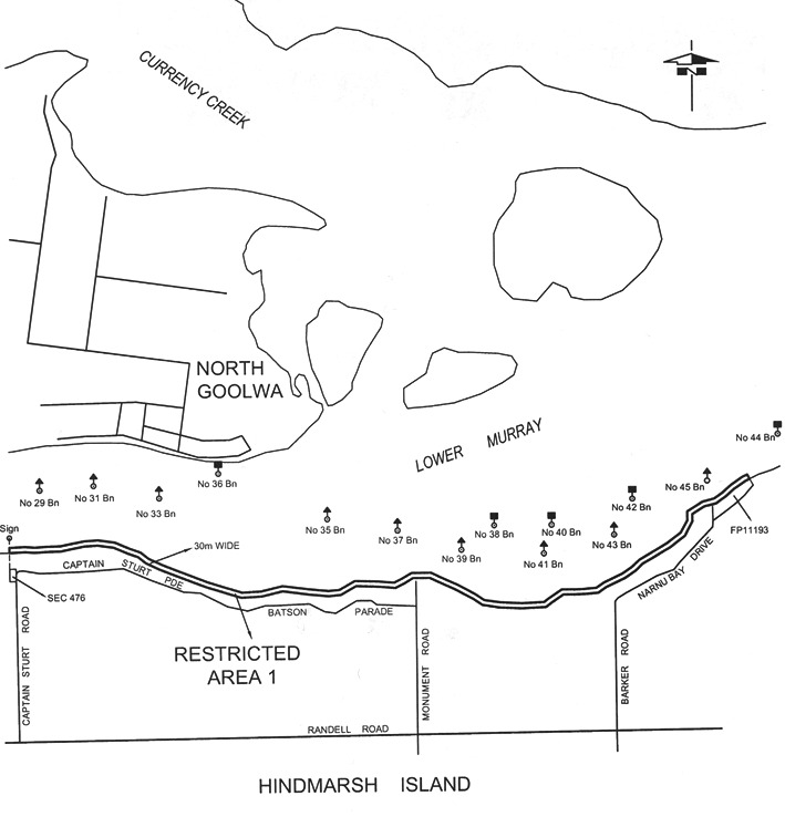
Goolwa
Area 1 : the portion of the River Murray at Goolwa bounded as follows:
• on the west by
a straight line being the prolongation northerly of the western boundary of
Section 476, Hundred of Nangkita, Hindmarsh Island;
• on the
north-west by a line 30 m from, and parallel to the edge of the water;
• on the
north-east by a straight line being the prolongation north-westerly of the
north-eastern boundary of FP11193;
• on the south
by the edge of the water on the north side of Hindmarsh Island.
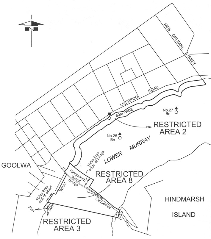
Area 2 : the portion of the River Murray at Goolwa bounded as follows:
• on the east by
the prolongation southerly of the eastern boundary of New Orleans Street;
• on the south
by a line 60 m from and parallel to the edge of the water;
• on the west by
a straight line 100 m upstream from and parallel to the Hindmarsh Island
Bridge;
• on the north
by the edge of the water.
Area 3 : the portion of the River Murray at Goolwa bounded as follows:
• on the
south-west by a straight line 100 m downstream from the south-east corner
of the Goolwa wharf and at right angles to the production of the face of the
wharf;
• on the
north-west by the edge of the water;
• on the north
by a straight line 50 m downstream from the south east corner of the
Goolwa wharf and at right angles to the edge of the water;
• on the
south east by a line 30 m from and parallel to the edge of the
water.
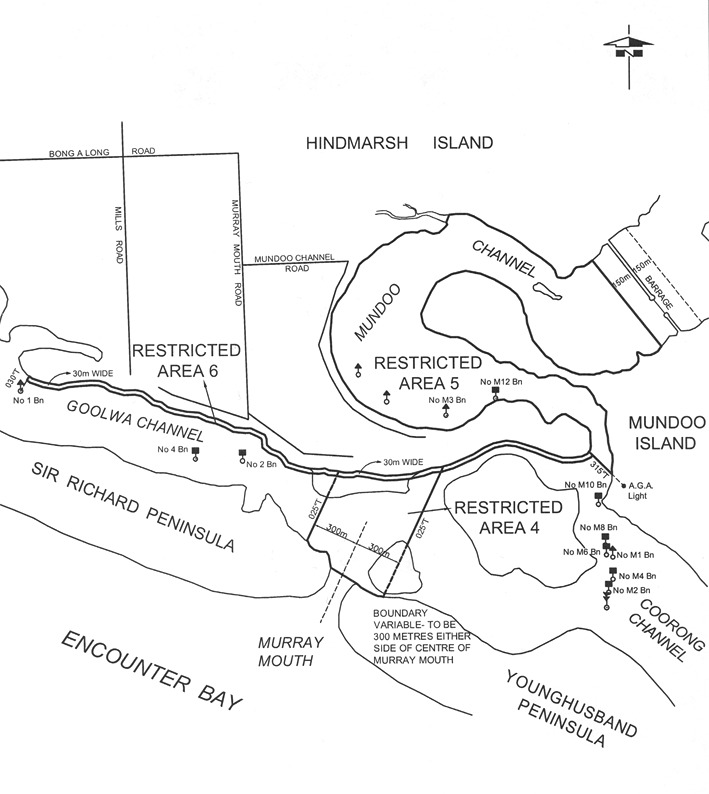
Area 4 : those portions of the River Murray and the Coorong in the vicinity of
the Murray Mouth bounded as follows:
• on the east
and west by lines bearing 025° True and 300 m distant from the
centre (for the time being) of the Murray Mouth;
• on the north
by the edge of the water on the southern side of Hindmarsh Island;
• on the
south-west by the edge of the water on the River Murray side of
Sir Richard Peninsula;
• on the
south-east by the edge of the water on the Coorong side of Younghusband
Peninsula;
• on the south
by a straight line across the Murray Mouth joining the westerly extremity of
Younghusband Peninsula to the easterly extremity of Sir Richard Peninsula.
Area 5 : the portion of the Mundoo Channel to the edge of the water bounded as
follows:
• on the
north-east by a straight line 150 m downstream and parallel to the
south-west side of the Mundoo Barrage;
• on the south
by a straight line bearing 315° True from the AGA light on Mundoo
Island.
Area 6 : those portions of the River Murray and the Coorong in the vicinity of
the Murray Mouth bounded as follows:
• on the north
by the edge of the water on the southern side of Hindmarsh Island;
• on the west by
a line bearing 030° True from No 1 beacon;
• on the east by
a line bearing 315° True from the AGA light on Mundoo Island;
• on the south
by a line 30 m from and parallel to the edge of the water.
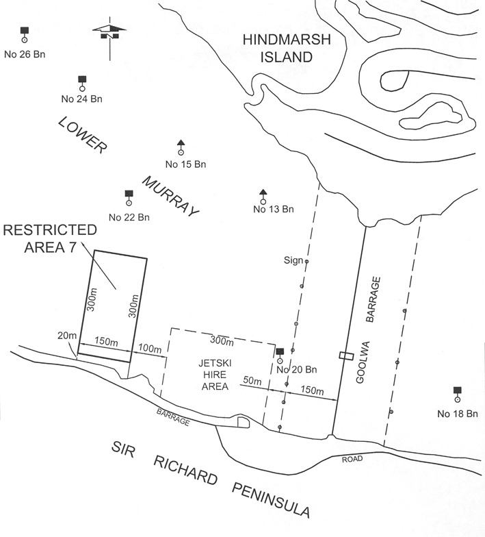
Area 7 : the portion of the River Murray at Goolwa bounded as follows:
• on the east by
a straight line extending 300 m northwards from a point 20 m from
the southern waters edge, parallel to and 600 m upstream from the Goolwa
Barrage;
• on the west by
a straight line extending 300 m northwards from a point 20 m from
the southern waters edge, parallel to and 750 m upstream from the Goolwa
Barrage;
• on the north
by a straight line joining the northern extremities of the eastern and western
boundaries;
• on the south
by a line parallel to and 20 m from the edge of the water.
Area 8 : the portion of the River Murray at Goolwa bounded as follows:
• on the south
by a straight line from a point on the edge of the water at Goolwa 100 m
downstream from the southern end of the Goolwa wharf to a point on the western
side of Hindmarsh Island, 70 m south of the northern corner of the
Hindmarsh Island end of the causeway;
• on the east by
the edge of the water on the western side of Hindmarsh Island;
• on the north
by a line from a point on the edge of the water at Goolwa 100 m upstream
from the northern face of the Hindmarsh Island Bridge, then parallel to the
northern face of the Bridge to the point at which that line intersects a line
perpendicular to the Bridge extending from the tip of the causeway in a
generally north-easterly direction, then along the latter line to the tip of
the causeway, then along the northern face of the causeway;
• on the west by
the face of the Goolwa wharf and the edge of the water.
Henley Beach
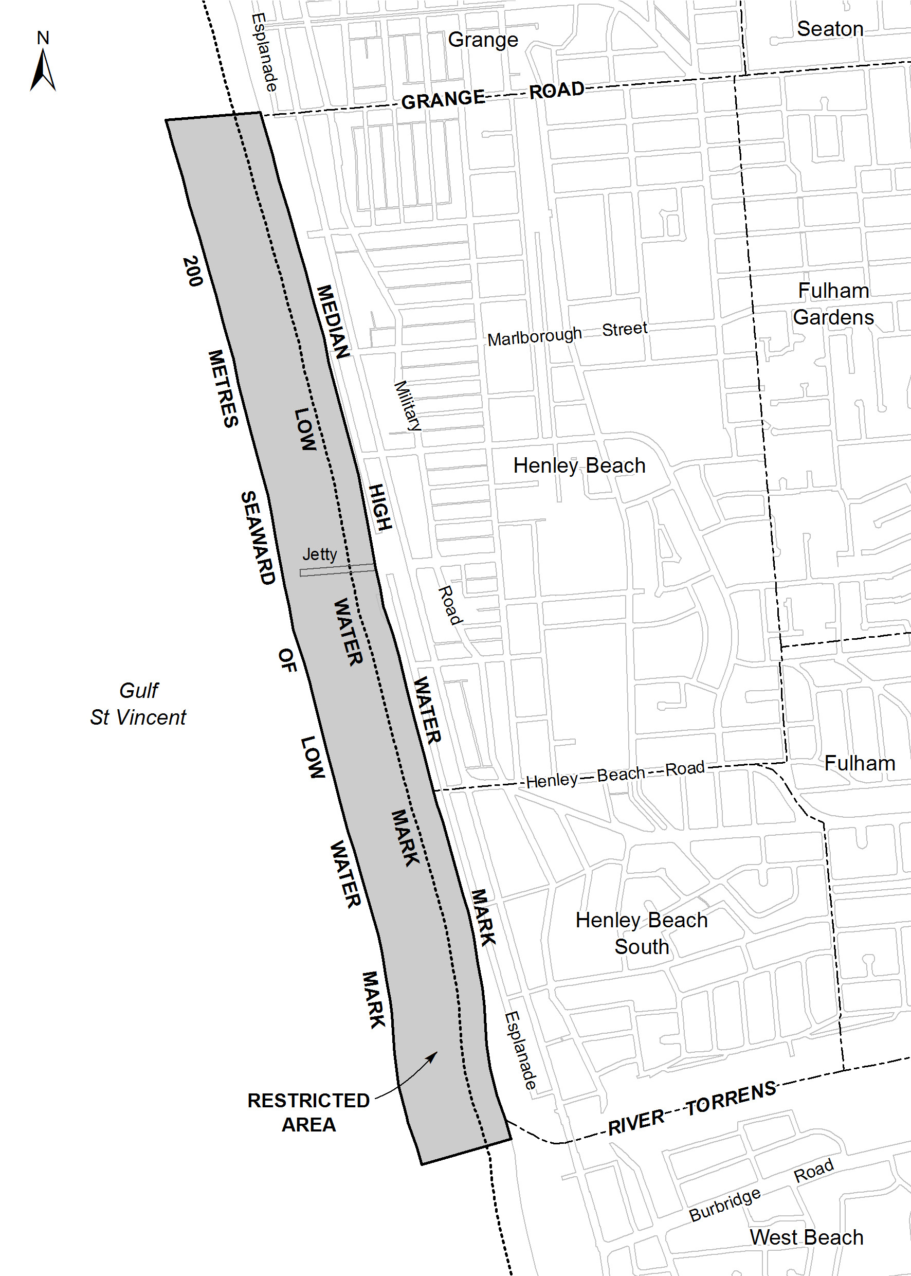
The portion of the waters of Gulf St. Vincent at Henley Beach bounded as
follows:
• on the north
by a straight line being the production seaward of the north alignment of
Grange Road;
• on the south
by a straight line being the production seaward of the north alignment of the
River Torrens outfall;
• on the east by
the High Water Mark;
• on the west by
a line 200 m from, and parallel to, the Low Water Mark.
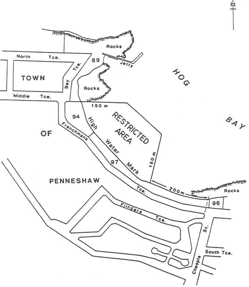
Hog Bay
The portion of the sea at Hog Bay on Kangaroo Island bounded as follows:
• on the north
by a straight line being the prolongation of the south boundary of Middle
Terrace for a distance of 150 m seawards from the High Water Mark;
• on the east by
a straight line parallel to the west boundary of Cheopis Street and commencing
at a point 200 m westerly along the High Water Mark from the prolongation
of the west boundary at Cheopis Street, and extending 150 m seaward from
the High Water Mark;
• on the
north-east by a straight line joining the seaward extremities of the north and
east boundaries;
• on the
south-west by the High Water Mark.
Kellidie Bay
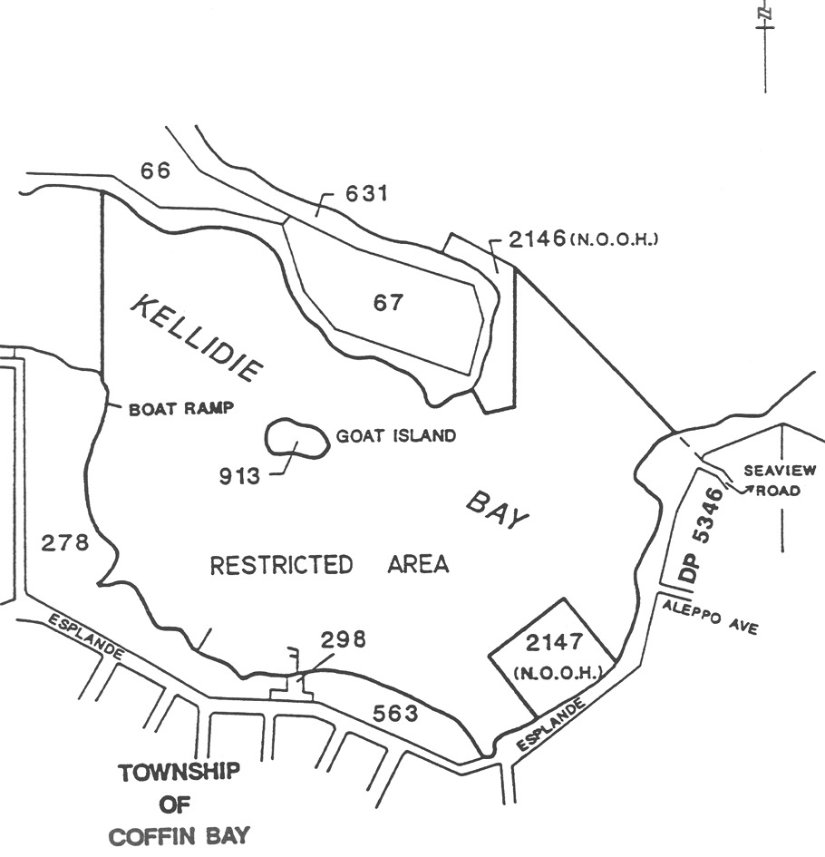
The portion of the sea at Kellidie Bay bounded as follows:
commencing at a point being the southern corner of section 2147 North Out
of Hundreds, then north-west along the High Water Mark to its intersection
with the north-eastern corner of section 278 Hundred of Lake Wangary,
then north along a straight line to its intersection with the High Water Mark
at section 631 Hundred of Lake Wangary, then south-west along the High
Water Mark to its intersection with the south-western corner of
Section 2146 North Out of Hundreds, then south-east along the
south-western boundary of Section 2146 North Out of Hundreds to its
southern corner, then east along its southern boundary to its south-eastern
corner and then north along its eastern boundary to its north-eastern corner,
then south-east along a straight line to its intersection with the High Water
Mark at a point being the prolongation of the north boundary of Seaview Road,
then south along the High Water Mark to its intersection with the eastern
corner of section 2147 North Out of Hundreds, then north-west along the
north-eastern boundary to its northern corner, then south-west along the
north-western boundary to its western corner, then south-east along its
south-eastern boundary to the point of commencement, but excluding Goat Island
(Section 913 Hundred of Lake Wangary).
Lake Bonney (Barmera)
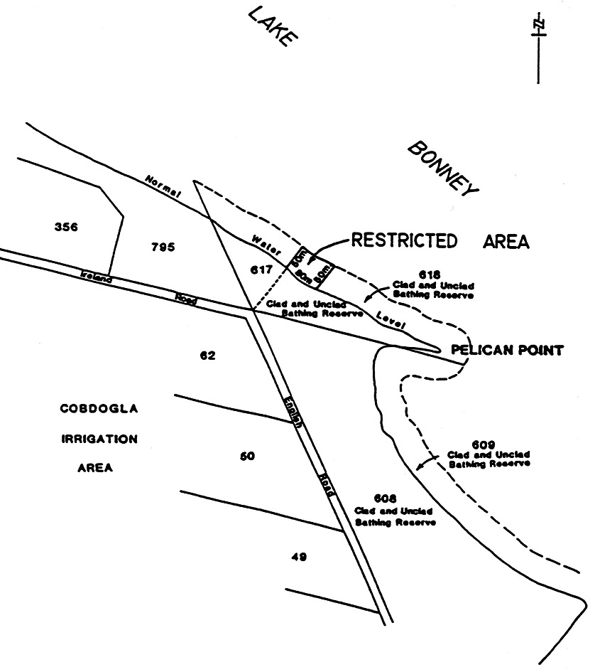
Area 1 : the portion of Lake Bonney marked out by flame orange spherical buoys
and yellow marker posts.
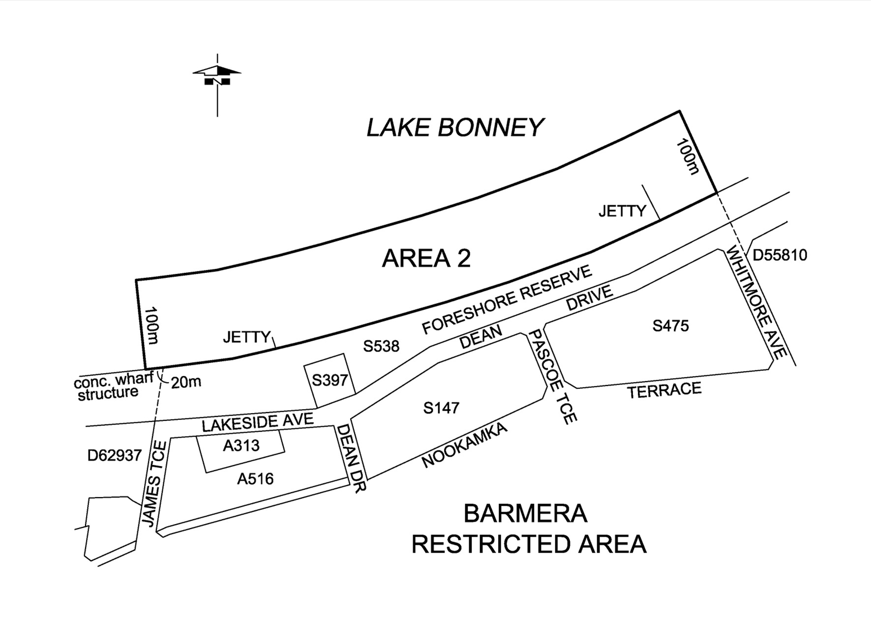
Area 2 : the portion of Lake Bonney bounded as follows:
• on the north
by a line 100 m from, and parallel to, the edge of the water;
• on the east by
the prolongation north-westerly of the north-eastern boundary of Whitmore
Avenue;
• on the south
by the edge of the water;
• on the west by
a straight line from the eastern end of the concrete wharf (approximately
20 m west of the prolongation northerly of the western boundary of James
Terrace) and at right angles to the edge of the water.
Lake Bonney (South East)
All the waters of Lake Bonney.
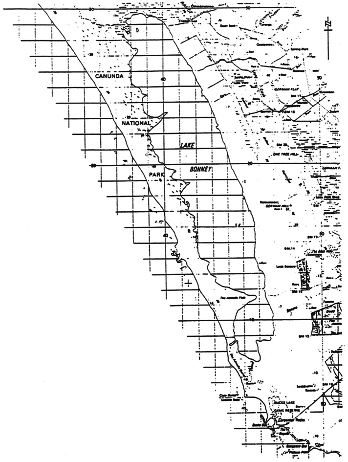
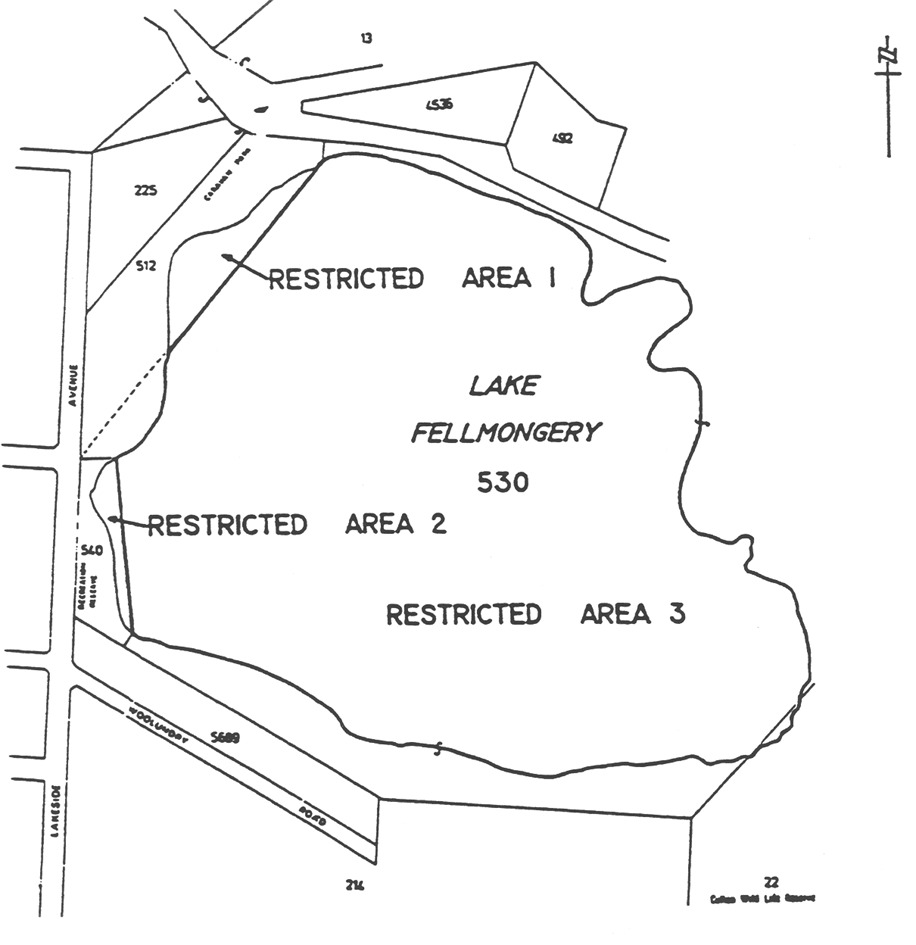
Lake Fellmongery
Area 1 : the portion of Lake Fellmongery at Robe bounded as follows:
• on the
south-east by a straight line joining the southerly extremity of the most
easterly boundary of Section 512, Hundred of Waterhouse, to the
intersection of the north alignment of Tobruk Avenue and the west alignment of
Lakeside Avenue, the line being marked by a yellow marker post at each of its
2 intersections with the edge of the water, and by a line of marker buoys
on the lake;
• on the west
and north-west by the edge of the water.
Area 2 : the portion of Lake Fellmongery at Robe bounded as follows:
• on the east by
a straight line joining the north-east corner of Section 540, Hundred of
Waterhouse, to the south-east corner of allotment 1 in Lands Titles
Office Deposited Plan No 5689, the line being marked by a yellow marker
post at each of its 2 intersections with the edge of the water, and by a
line of marker buoys on the lake;
• on the
south-west and north-west by the edge of the water.
Area 3 : the portion of Lake Fellmongery not included in Areas 1 and 2.
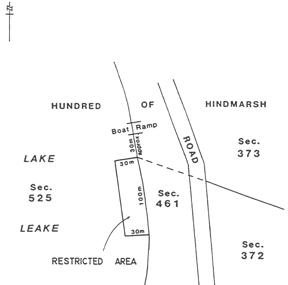
Lake Leake
The area of Lake Leake bounded as follows:
• on the north
by a straight line commencing at a point, being the intersection of the east
boundary of Section 525 Hundred of Hindmarsh and the north-westerly
production of the north-east boundary of Section 372 Hundred of
Hindmarsh, and extending westerly at right angles to the water's edge for a
distance of 30 m;
• on the east by
a line extending southerly along the east boundary of Section 525 Hundred
of Hindmarsh from the north boundary for a distance of 100 m;
• on the south
by a straight line commencing at the south extremity of the east boundary and
extending westerly at right angles to the water's edge for a distance of
30 m;
• on the west by
a straight line joining the west extremities of the north and south
boundaries.
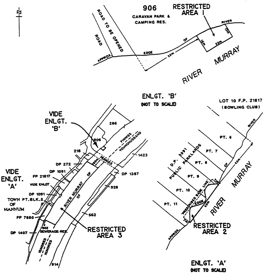
Mannum
Area 1 : the portion of the River Murray at Mannum bounded as follows:
• on the
south-west, by a straight line from the edge of the water for a distance of
16 m in a south-easterly direction parallel to and at a perpendicular
distance of 52 m north-east of the prolongation of the south-western
boundary of Section 906, Hundred of Finniss;
• on the
north-east, by a straight line from the edge of the water for a distance of
12 m in a south-easterly direction parallel to and at a perpendicular
distance of 77 m north-east of the prolongation of the south-western
boundary of Section 906, Hundred of Finniss;
• on the
south-east, by a straight line joining the southern extremities of the
south-western and north-eastern boundaries;
• on the
north-west, by the edge of the water.
Area 2 : the portion of the River Murray at Mannum bounded as follows:
• on the
south-west, by a straight line in a south-easterly direction from the
prescribed base line parallel to and at a perpendicular distance of 85 m
south-west of the prolongation of the south-western boundary of
Allotment 10 in Filed Plan 21817, Hundred of Finniss for a distance
of 7 m perpendicular to the prescribed base line;
• on the
north-east, by a straight line in a south-easterly direction from the
prescribed base line parallel to and at a perpendicular distance of 45 m
south-west of the prolongation of the south-western boundary of
Allotment 10 in Filed Plan 21817, Hundred of Finniss for a distance
of 7 m perpendicular to the prescribed base line;
• on the
south-east, by a straight line joining the southern extremities of the
south-western and north-eastern boundaries;
• on the
north-west, by the edge of the water.
Area 3 : the portion of the waters of the River Murray at Mannum delineated in
bold on the plan below as Area 3.
Meningie
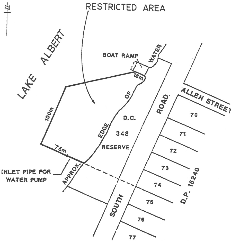
Area 1 : the portion of Lake Albert at Meningie bounded as follows:
• on the south,
by a straight line being the prolongation of the north boundary of
Allotment 75 in Development Plan 16240, Hundred of Bonney commencing
from the water's edge and extending in a westerly direction for a distance of
75 m;
• on the west,
by a straight line perpendicular to the south boundary commencing at its
western extremity and extending in a north-easterly direction for a distance
of 100 m;
• on the
north-east, by the southern side of the Meningie boat ramp commencing at the
water's edge and extending in a north-westerly direction for a distance of
18 m;
• on the
north-west, by a straight line joining the northern extremity of the west
boundary with the western extremity of the north-east boundary;
• on the east,
by the water's edge.
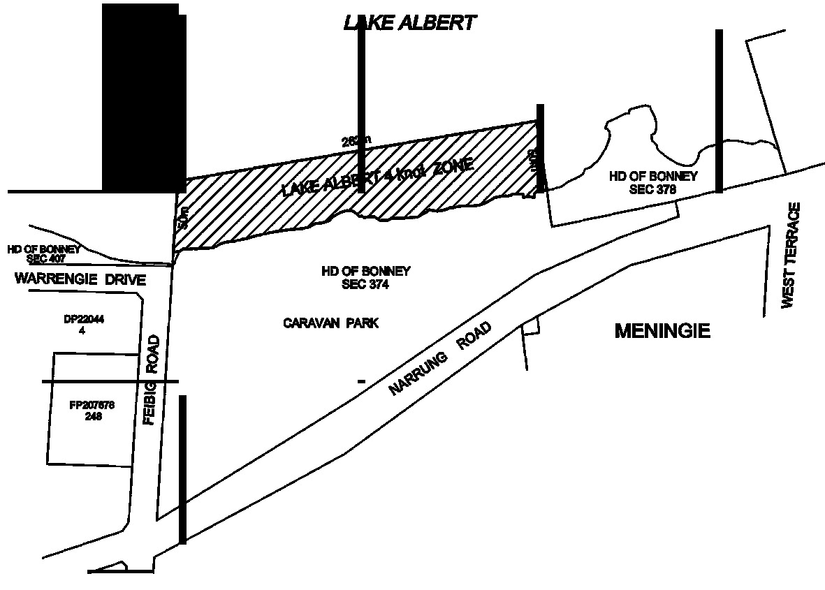
Area 2 : the portion of Lake Albert at Meningie bounded as follows:
• on the west,
by a straight line being the prolongation of the western boundary of
section 374 Hundred of Bonney commencing from the water's edge and
extending in a northerly direction for a distance of 50 m;
• on the east,
by a straight line being the prolongation of the western boundary of
section 378 Hundred of Bonney commencing from the water's edge and
extending in a northerly direction for a distance of 50 m;
• on the north,
by a straight line joining the northern extremity of the western boundary with
the northern extremity of the eastern boundary;
• on the south,
by the water's edge.
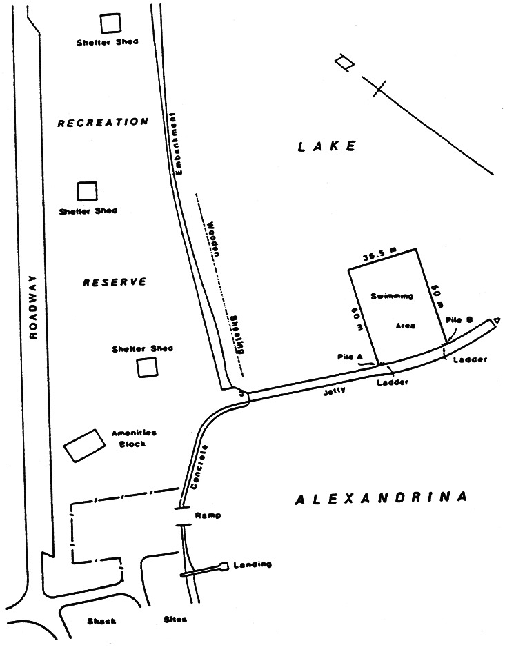
Milang
The portion of Lake Alexandrina at Milang bounded as follows:
• on the
north-east by a straight line parallel to and 50 m from a straight line
joining piles A and B;
• on the
north-west by a straight line commencing at pile A then heading
north-east to intersect the north-eastern boundary at right angles;
• on the
south-east by a straight line commencing at pile B then heading
north-east to intersect the north-eastern boundary at right angles;
• on the
south-west by the north-eastern face of the jetty between piles A
and B.
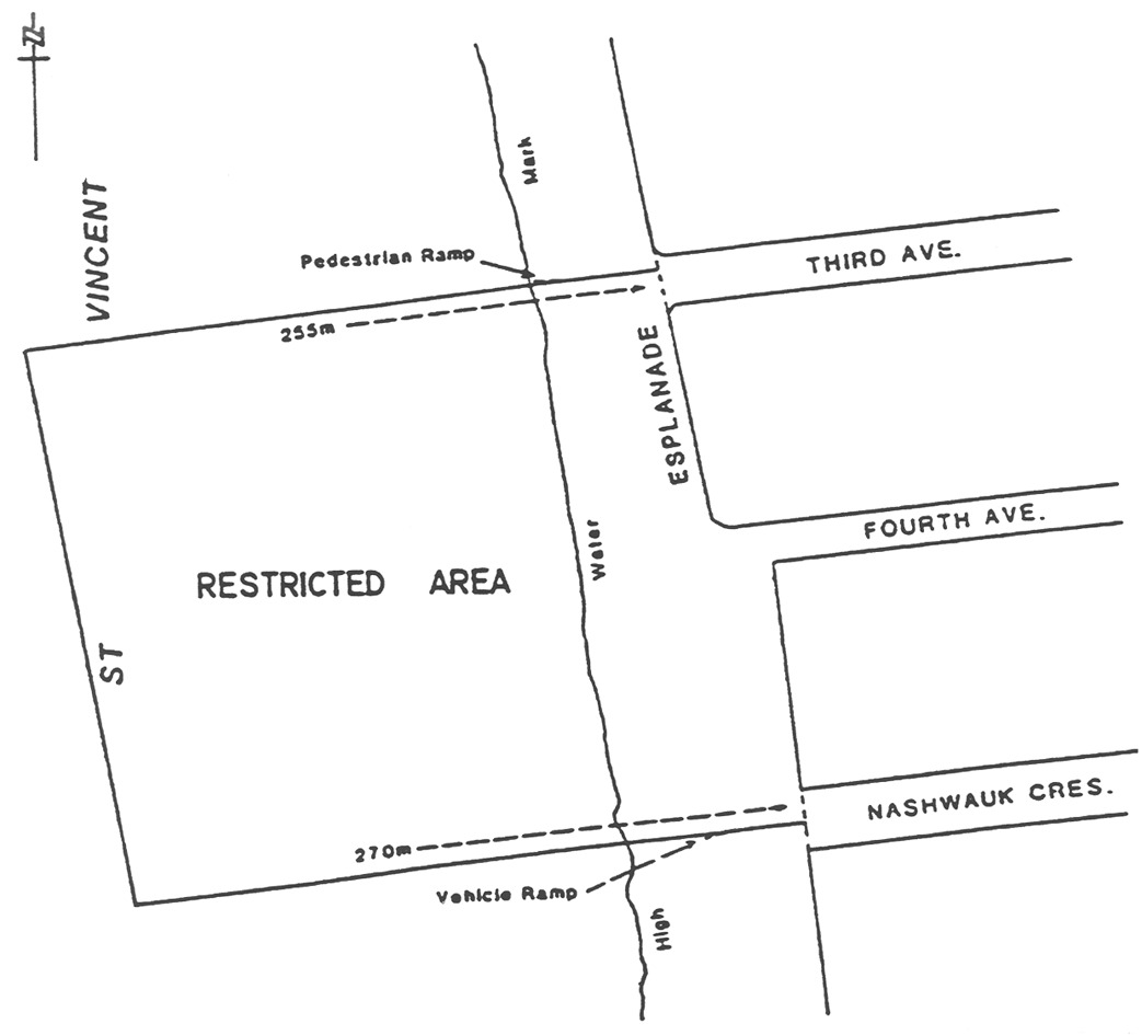
Moana
The portion of the sea at Moana bounded as follows:
• on the north
by a straight line west of and parallel to the north side of Third Avenue,
that line passing through the south extremity of the pedestrian ramp to the
beach and extending for 255 m west of the east alignment of the
Esplanade;
• on the south
by a straight line west of and parallel to the south side of the west end of
Nashwauk Crescent, that line passing through the north extremity of the
vehicle ramp to the beach and extending for 270 m west of the east
alignment of the Esplanade;
• on the west by
a straight line joining the west extremities of the north and south
boundaries;
• on the east by
the High Water Mark.
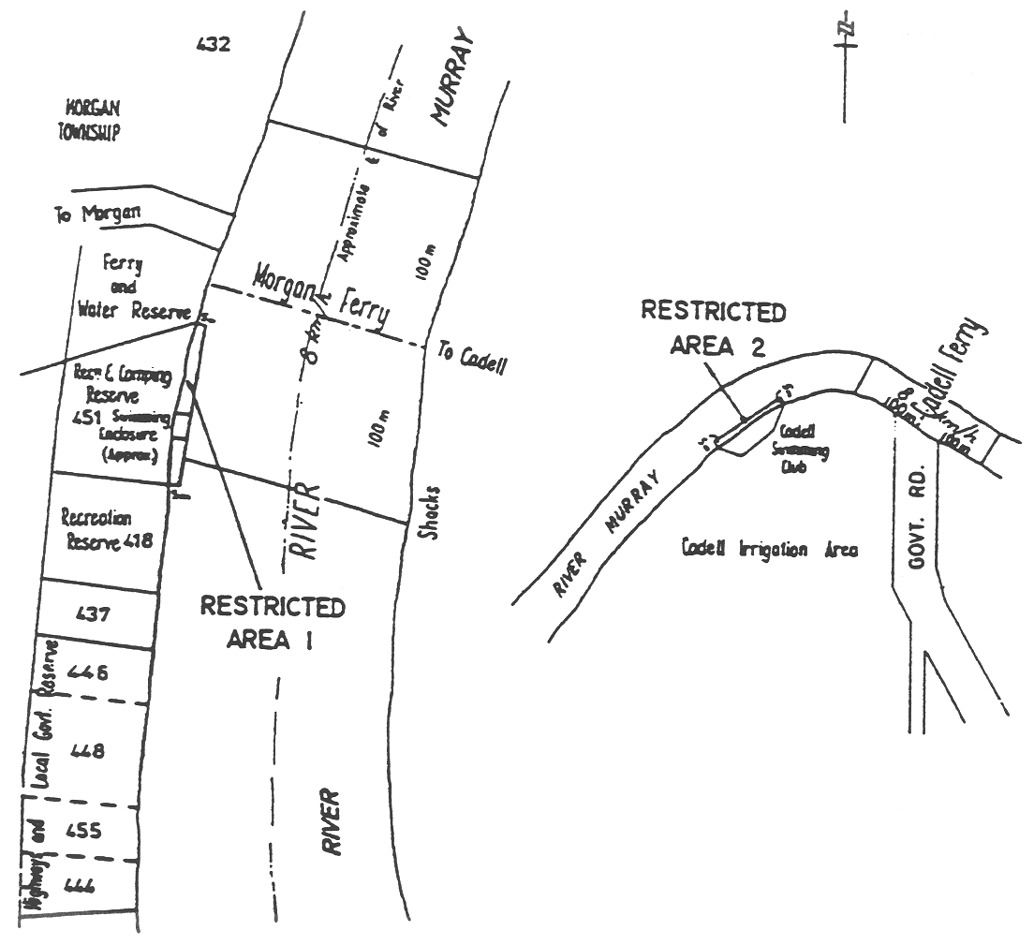
Morgan and Cadell
Area 1 : the portion of the River Murray at Morgan bounded as follows:
• on the north
by a straight line extending easterly from the yellow marker post situated on
the west bank of the River Murray at the north-east corner of
Section 451, Hundred of Eba, for 5 m beyond and at right angles to
the edge of the water;
• on the south
by a straight line extending easterly from the yellow marker post situated on
the west bank of the River Murray at the south-east corner of
Section 451, Hundred of Eba, for 5 m beyond and at right angles to
the edge of the water;
• on the east by
a straight line joining the easterly extremities of the north and south
boundaries;
• on the west by
the edge of the water between those 2 yellow marker posts.
Area 2 : the portion of the River Murray at Cadell bounded as follows:
• on the
south-east by the edge of the water between the 2 yellow marker posts
situated on the south-east bank of the River Murray, the upstream post being
approximately 160 m west of the north-west corner of Cadell Valley Road
immediately south of the Cadell ferry crossing, and the downstream post being
approximately 90 m south-west of the upstream post;
• on the
north-east by a straight line extending north-westerly from the upstream
yellow marker post of the 2 posts previously defined, for 5 m beyond
and at right angles to the edge of the water;
• on the
south-west by a straight line extending north-westerly from the downstream
yellow marker post of the 2 posts previously defined, for 5 m beyond
and at right angles to the edge of the water;
• on the
north-west by a straight line joining the north-westerly extremities of the
north-east and south-west boundaries.
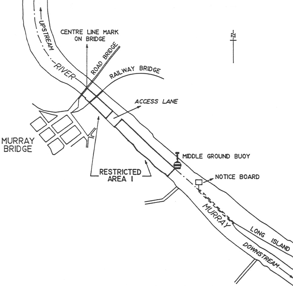
Murray Bridge
Area 1 : the portion of the River Murray at Murray Bridge bounded as follows:
• on the
north-east by the centre line of the river;
• on the
south-east by a straight line extending south-west from the middle ground buoy
to the south-west from the middle ground buoy to the south-west bank of the
river;
• on the
north-west by a line extending from the red mark C on the upstream side
of the road traffic bridge, south-west along the line of the north-west
(upstream) side of the road traffic bridge to the south-west bank of the
river, and on the south-west by the south-west bank of the river, except for
an accessway between the south-west bank of the river and the centre line of
the river extending north-west for a distance of 100 m from a line being
the north-west boundary of allotment 30 in Lands Titles Registration Office
Plan No 1443.
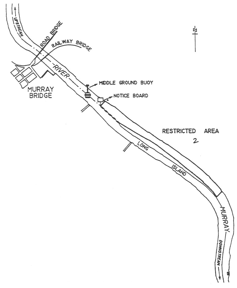
Area 2 : the portion of the River Murray at Murray Bridge on the north-east
side of Long Island bounded as follows:
• on the
north-east by the north-east bank of the river;
• on the
south-east by a straight line from the south-east (downstream) extremity of
Long Island north-east to the north-east bank of the river;
• on the
north-west by a straight line from the notice board north-east to the
north-east bank of the river;
• on the
south-west by a straight line from the notice board to the north-west
(upstream) end of Long Island, then generally south-east along the north-east
side of Long Island to its south-east (downstream) extremity.
Murray Bridge (bathing)
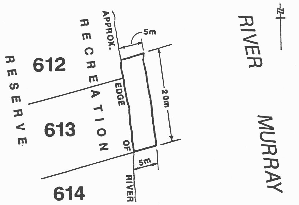
Area 1 : the portion of the River Murray at Murray Bridge (Wellington Reserve)
bounded as follows:
• on the south
by a line being the prolongation of the southern boundary of Lot 613,
Town of Wellington, easterly for a distance of 5 m from the waters edge;
• on the north
by a line running easterly from the waters edge for a distance of 5 m and
at a distance of 20 m in a northerly direction from the southern boundary
of Lot 613, Town of Wellington;
• on the east by
a line joining the eastern extremities of the north and south boundaries and
parallel to the waters edge;
• on the west by
the waters edge.
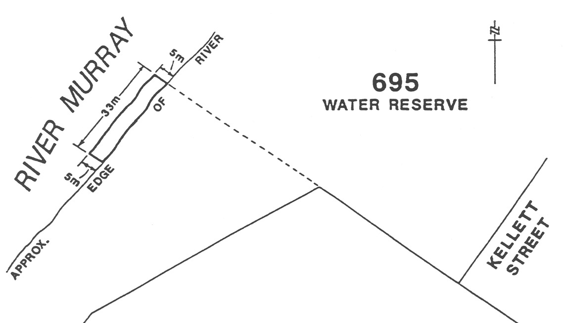
Area 2 : the portion of the River Murray at Murray Bridge (Bells
Landing—Monteith) bounded as follows:
• on the
north-east by a line being the prolongation of a boundary of Section 695
on line with the south-western end of Kellett Street, Hundred of Burdett,
westerly for a distance of 5 m from the waters edge;
• on the
south-west by a straight line running north-westerly from the waters edge for
a distance of 5 m parallel to and at a distance of 30 m from the
north-east boundary;
• on the
north-west by a line joining the western extremities of the north-east and
south-west boundaries and parallel to the waters edge;
• on the south
east by the waters edge.
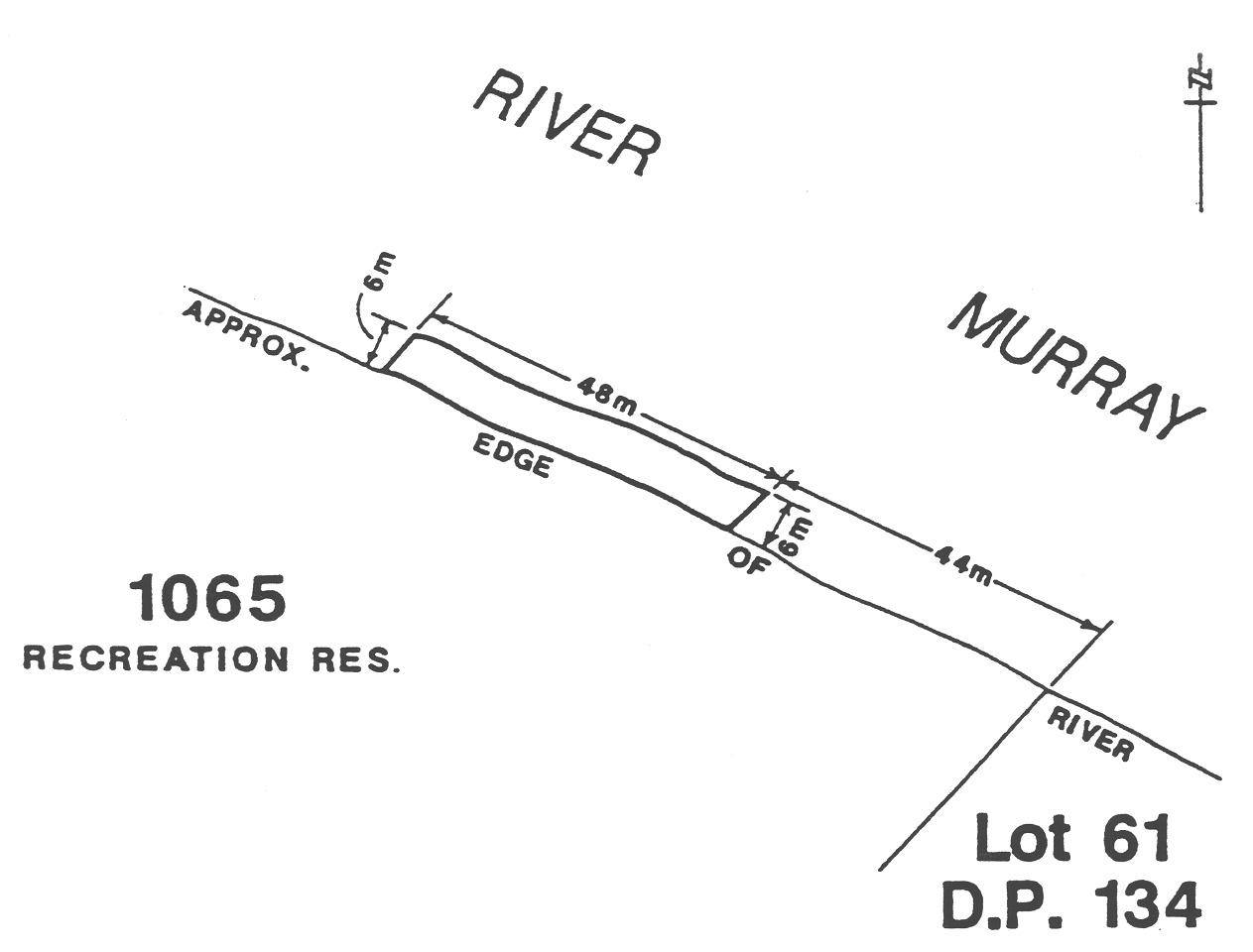
Area 3 : the portion of the River Murray at Murray Bridge (Swanport Reserve)
bounded as follows:
• on the
south-east by a straight line running north-easterly from the waters edge for
a distance of 6 m at a distance of 44 m in a north-westerly
direction along the waters edge from the north-eastern corner of
Section 1065, Hundred of Mobilong;
• on the
north-west by a straight line running north-easterly from the waters edge for
a distance of 6 m parallel to and at a distance of 92 m in a
north-westerly direction along the waters edge from the north-eastern boundary
of Section 1065, Hundred of Mobilong;
• on the
north-east by a line joining the eastern extremities of the south-east and
north-west boundaries and parallel to the waters edge;
• on the
south-west by the waters edge.
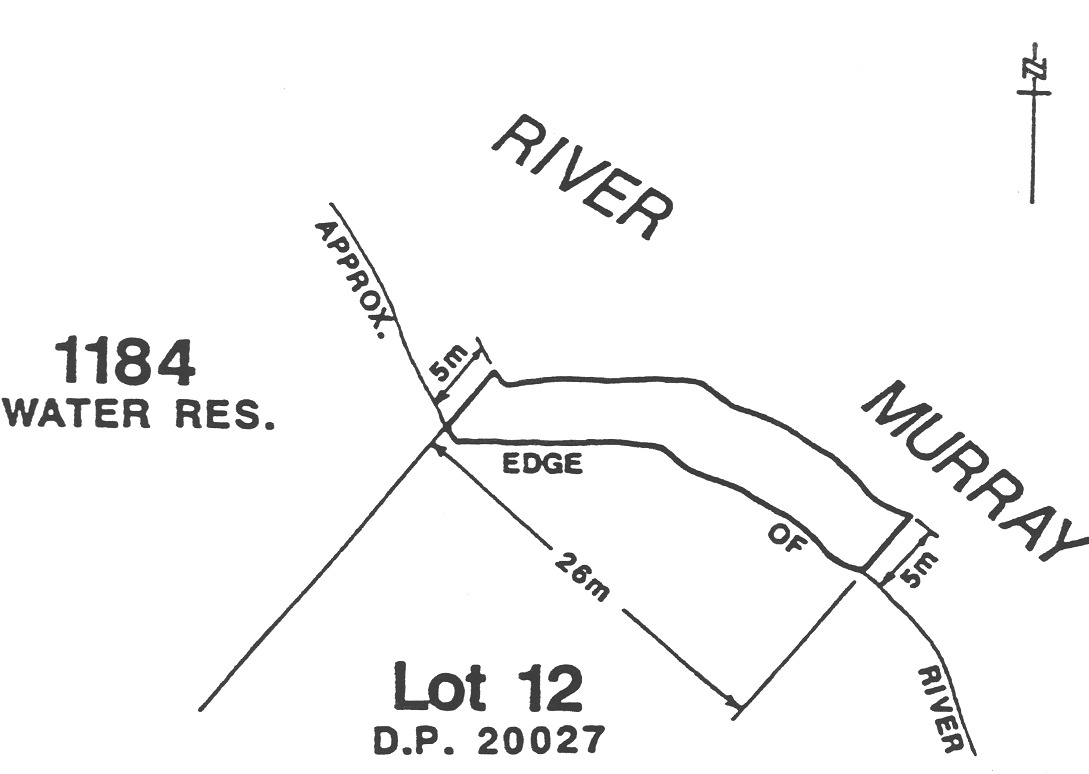
Area 4 : the portion of the River Murray at Murray Bridge (Long Island
Reserve) bounded as follows:
• on the
north-west by a line being the prolongation of the north-western boundary of
Lot 12, Deposited Plan No 20027, north-easterly for a distance of
5 m from the waters edge;
• on the
south-east by a straight line running north-easterly from the waters edge for
a distance of 5 m at a distance of 26 m in a south-easterly
direction from the north-western corner of Lot 12, Deposited Plan
No 20027;
• on the
north-east by a line joining the north-eastern extremities of the north-west
and south-east boundaries and parallel to the waters edge;
• on the
south-east by the waters edge.
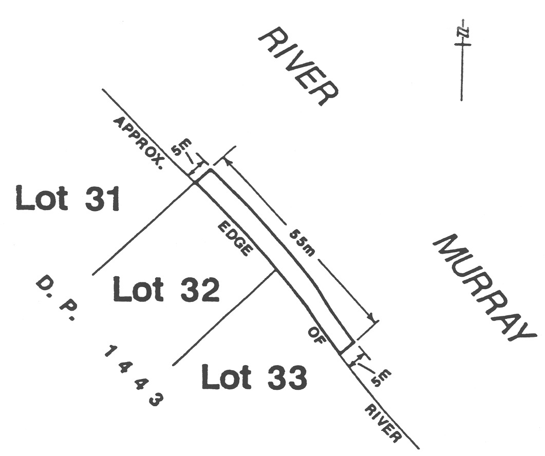
Area 5 : the portion of the River Murray at Murray Bridge (Sturt Reserve)
bounded as follows:
• on the
north-west by a line being the prolongation of the north-western boundary of
Lot 32, Deposited Plan No 1443, north-easterly for a distance of
5 m from the waters edge;
• on the
south-east by a straight line running north-easterly from the waters edge for
a distance of 5 m at a distance of 55 m in a south-easterly
direction along the waters edge from the northern corner of Lot 32,
Deposited Plan No 1443;
• on the
north-east by a line joining the north-eastern extremities of the north-west
and south-east boundaries and parallel to the waters edge;
• on the
south-east by the waters edge.
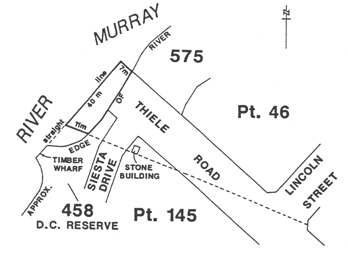
Area 6 : the portion of the River Murray at Murray Bridge (Thiele Reserve)
bounded as follows:
• on the
north-east by a line being the prolongation of the south-western boundary of
Section 575, Hundred of Burdett, north-westerly for a distance of
7 m from the waters edge;
• on the
south-west by a straight line running north-westerly from the waters edge for
a distance of 11 m on the prolongation of a line joining the
south-eastern corner of Lincoln Street with the south-western wall of the
stone building on the south-eastern corner of the intersection of Siesta Drive
and Thiele Road, Hundred of Burdett;
• on the
north-west by a line joining the north-western extremities of the north-east
and south-west boundaries (being part of a straight line joining the
north-western extremity of the north-eastern boundary with the north-eastern
tip of the Timber Wharf in Section 458, Hundred of Burdett);
• on the
south-east by the waters edge.
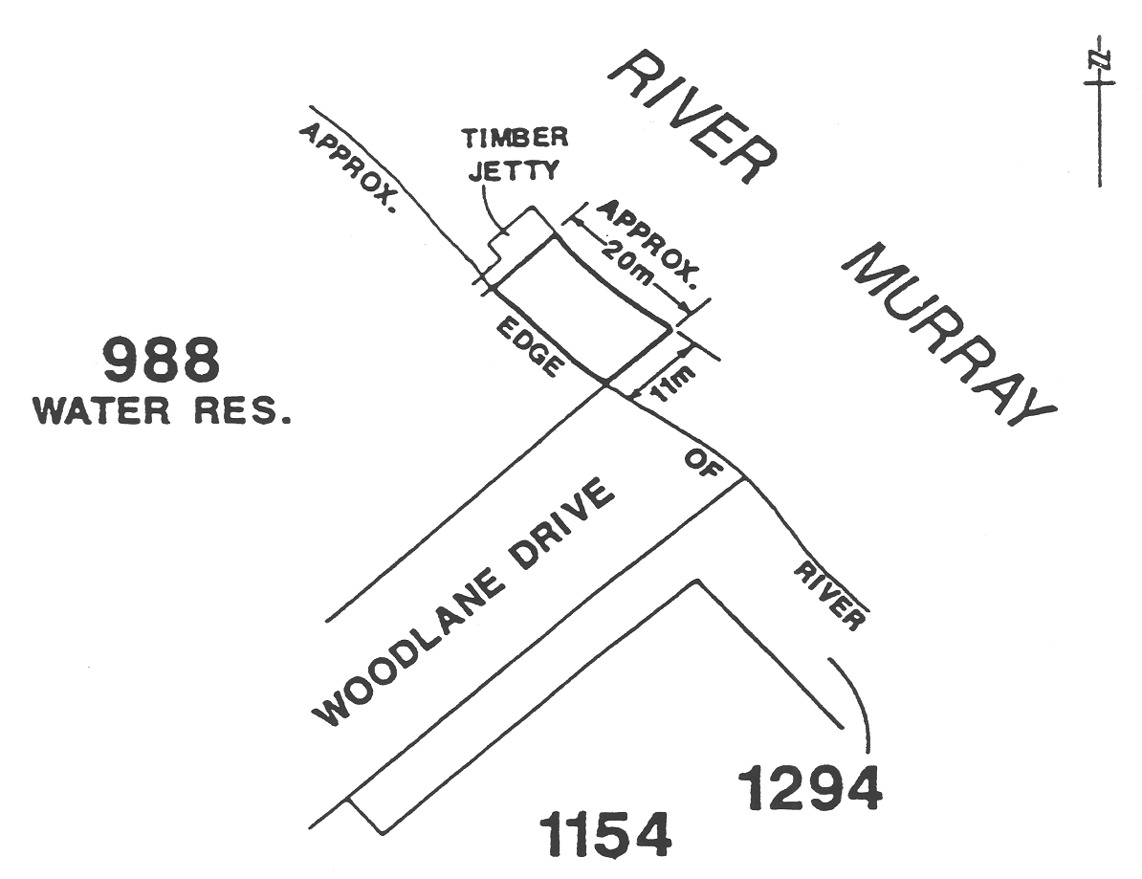
Area 7 : the portion of the River Murray at Murray Bridge (Woodlane Reserve)
bounded as follows:
• on the
south-east by a line being the prolongation of the south-eastern boundary of
Section 988, Hundred of Mobilong, north-easterly for a distance of
11 m from the waters edge;
• on the
north-west by the south-eastern face of the Timber Jetty approximately
20 m north-west along the waters edge from the south-eastern boundary of
Section 988, Hundred of Mobilong;
• on the
north-east by a line joining the north-eastern extremities of the north-west
and south-east boundaries and parallel to the waters edge;
• on the
south-east by the waters edge.
Nildottie
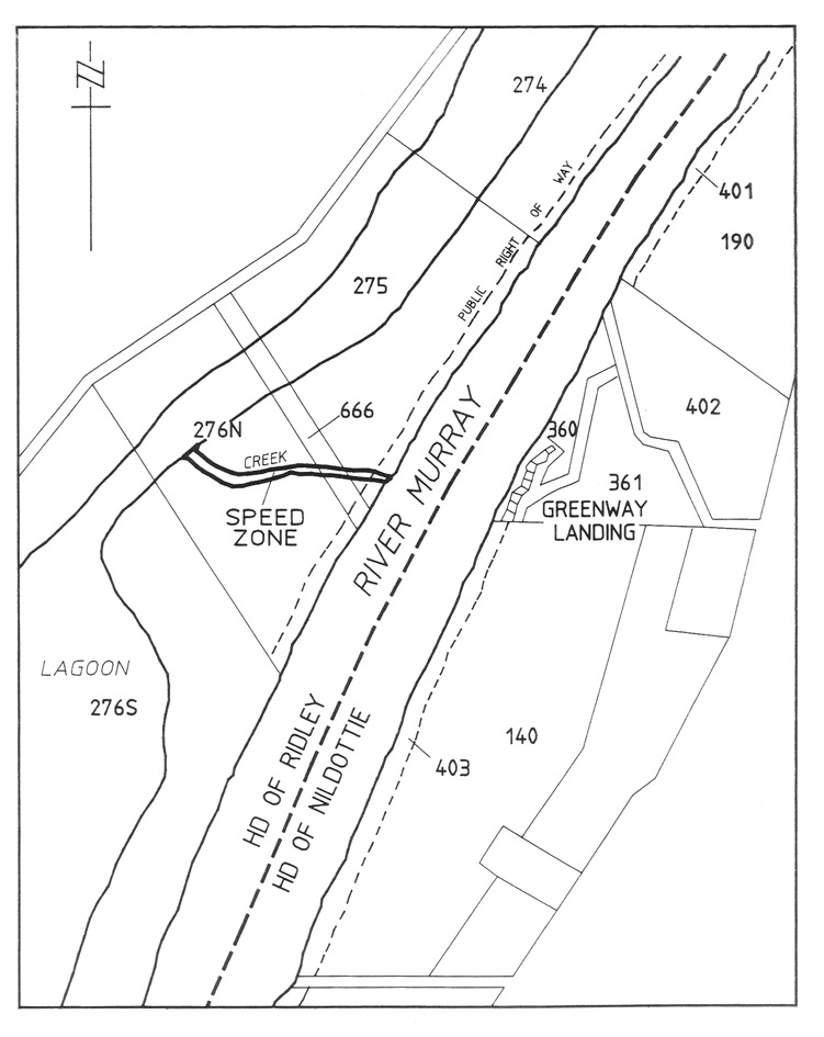
The creek flowing between the River Murray and the Lagoon through
sections 275, 666 and 276N, Hundred of Ridley, delineated in bold on the
plan below:
North Haven Marina
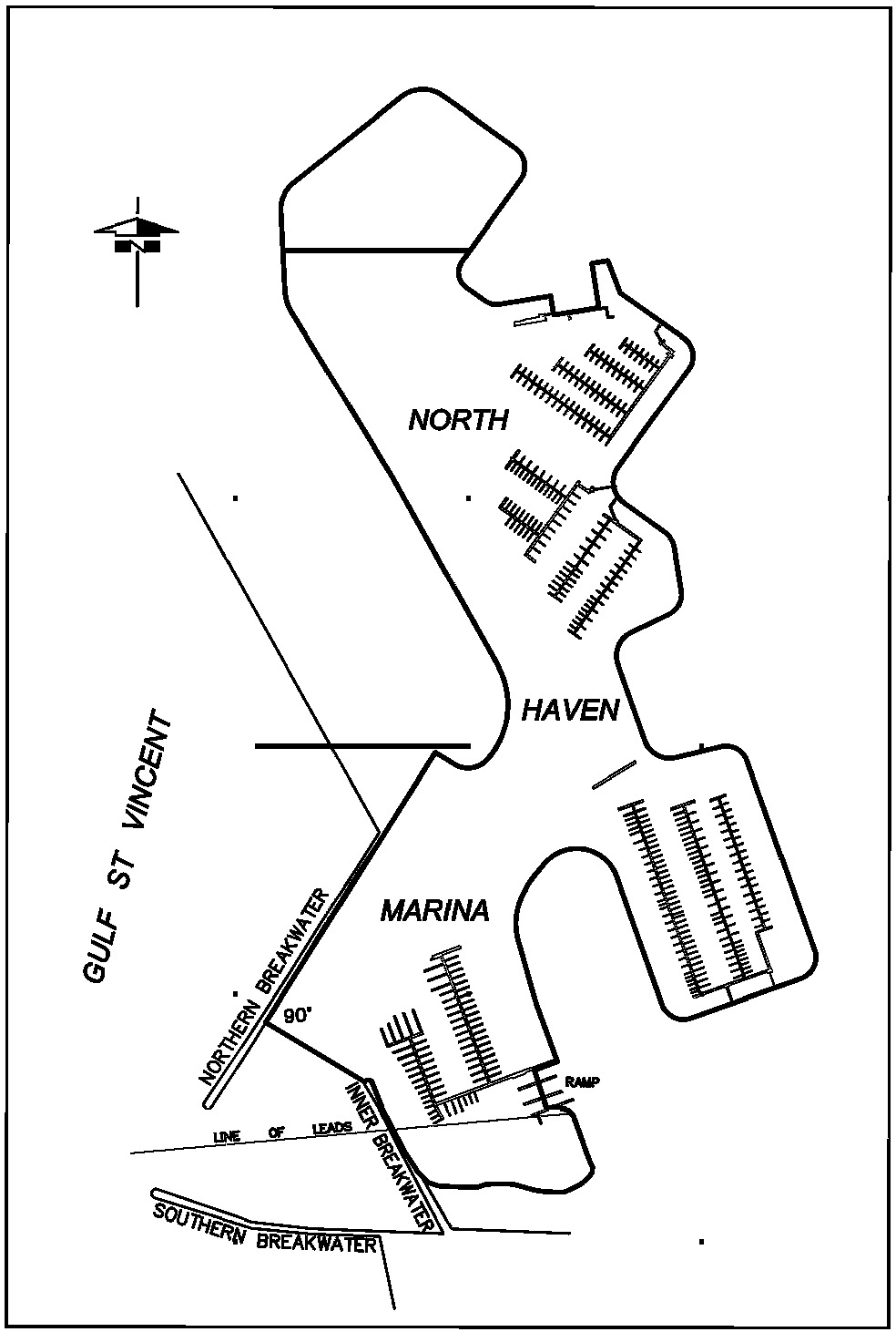
The portion of the waters of the North Haven marina bounded by and to the east
of a line commencing at the seaward end of the inner breakwater and extending
in a north-westerly direction to intersect perpendicularly with the northern
breakwater.
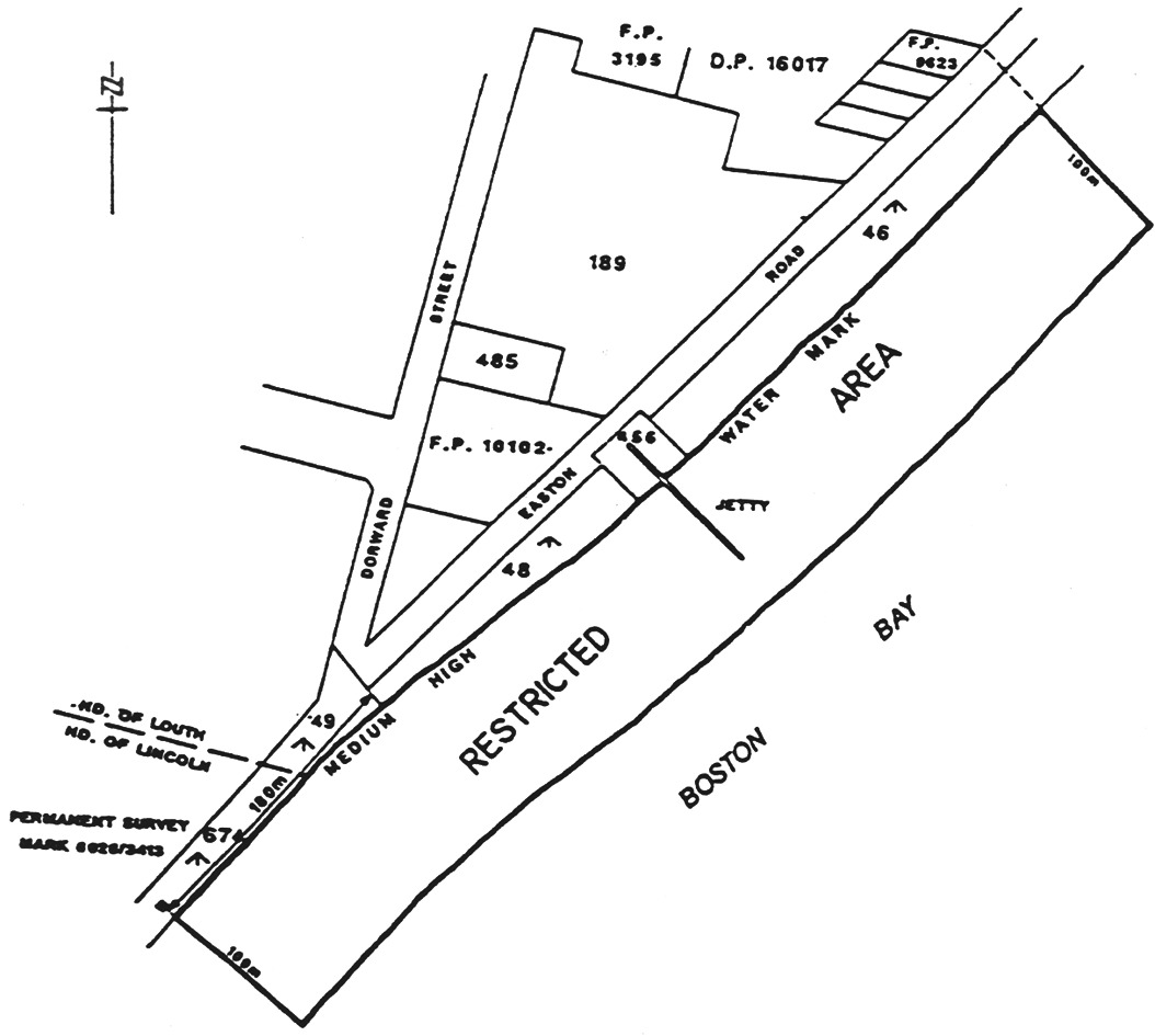
North Shields
The portion of the waters of the sea at North Shields delineated in bold on
the plan below:
O'Sullivan Beach
The area of the sea at O'Sullivan Beach bounded as follows:
commencing at a point being the intersection with the High Water Mark of a
line 10 m north of and parallel to the High Water Mark on the north side
of the inner breakwater, then west along that line to its intersection with
the circumference of a circle of 75 m radius centred on the light at the
seaward end of the outer breakwater, then anti-clockwise around that
circumference to its intersection with a line 10 m south-west of and
parallel to the High Water Mark on the south-west side of the outer
breakwater, then south-east along that line to its intersection with the High
Water Mark, then along the High Water Mark to the point of commencement.

Point Turton
Area 1 : the portion of the sea at Hardwicke Bay in Spencer Gulf near Point
Turton bounded as follows:
• on the west by
a straight line being the prolongation northerly of the west boundary of
Section 383, Hundred of Para Wurlie commencing at a point at which that
line intersects the High Water Mark (marked by a marker post) and extending
150 m seaward;
• on the east by
a straight line parallel to and 200 m to the east of the west boundary of
Area 1 described above commencing at a point at which that line
intersects the High Water Mark (marked by a marker post) and extending
150 m seaward;
• on the north
by a straight line joining the northernmost extremities of the east and west
boundaries;
• on the south
by the High Water Mark.

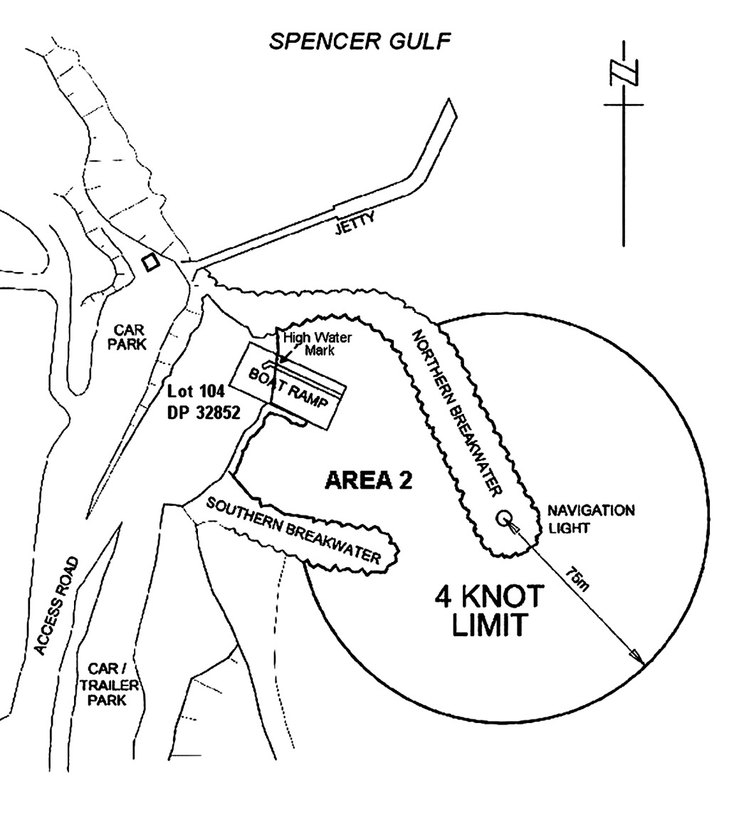
Area 2 : the portion of the waters of Hardwicke Bay in Spencer Gulf near Point
Turton described as "Area 2" on the plan below:
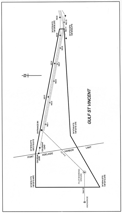
Port Adelaide
The portion of the waters of Port Adelaide and adjacent waters bounded as
follows:
• on the
north-east by a straight line commencing at a point at
latitude 34°46′35.81" South,
longitude 138°21′33.51" East and extending to a point at
latitude 34°47′25.61" South,
longitude 138°26′38.28" East;
• on the east by
a straight line commencing at a point at latitude 34°47′25.61"
South, longitude 138°26′38.28" East and extending to a point
at latitude 34°47′34.62" South, longitude
138°26′38.27" East;
• on the south
by a straight line commencing at a point at latitude 34°47′34.62"
South, longitude 138°26′38.27" East and extending to a point at
latitude 34°47′46.01" South, longitude 138°22′18.12"
East;
• on the
south-west by a straight line commencing at a point at latitude
34°47′46.01" South, longitude 138°22′18.12" East and
extending to a point at latitude 34°48′44.07" South, longitude
138°20′12.23" East;
• on the west by
a straight line commencing at a point at latitude 34°48′44.07"
South, longitude 138°20′12.23" East and extending to a point at
latitude 34°46′35.71" South, longitude 138°20′12.48"
East;
• on the north
by a straight line commencing at a point at latitude 34°46′35.71"
South, longitude 138°20′12.48" East and extending to a point at
latitude 34°46′35.81" South, longitude 138°21′33.51"
East.
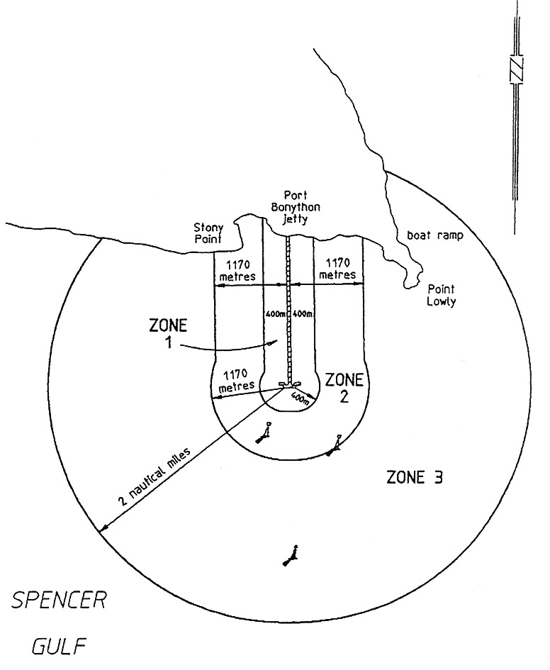
Port Bonython
Zone 1 : waters within 400 m of Port Bonython Jetty.
Zone 2 : waters within 1 170 m of Port Bonython Jetty.
Zone 3 : waters within 2 nautical miles of the berth operations signals
at the seaward end of Port Bonython Jetty.
Port Elliot
All the waters of Horseshoe Bay north-west of a line joining the eastern
extremity of the breakwater at Freeman Nob with Commodore Point.

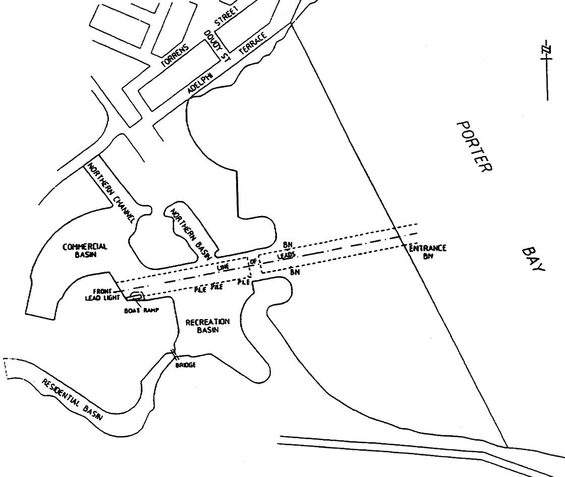
Porter Bay
The portion of the waters at Porter Bay to the west of an imaginary straight
line commencing from the seaward boundary of Adelphi Terrace where an obtuse
bend occurs, then to the outer entrance beacon of Lincoln Cove Marina and
prolongated until it meets the southern foreshore of Porter Bay.
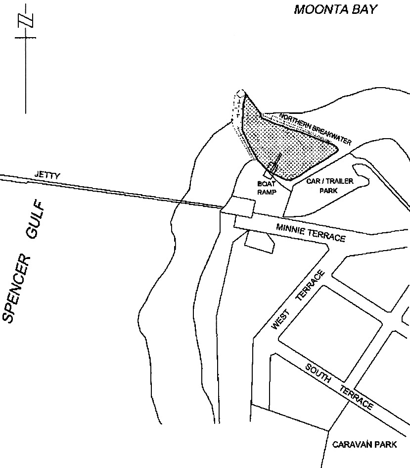
Port Hughes
The portion of the waters of the sea at Port Hughes within the Moonta Bay boat
ramp basin, landward of the northern and southern breakwater (shown as a
shaded area on the plan below).
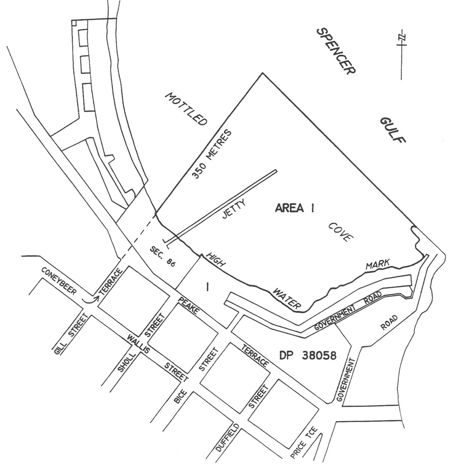
Port Neill
The portion of the sea at Port Neill bounded as follows:
• on the
north-west by a straight line being the prolongation seawards of the
north-west boundary of Gill Street and Coneybeer Terrace for a distance of
350 m from the High Water Mark;
• on the
south-west and south-east by the High Water Mark;
• on the
north-east by a straight line joining the seaward extremities of the
north-western boundary and the south-east the High Water Mark.
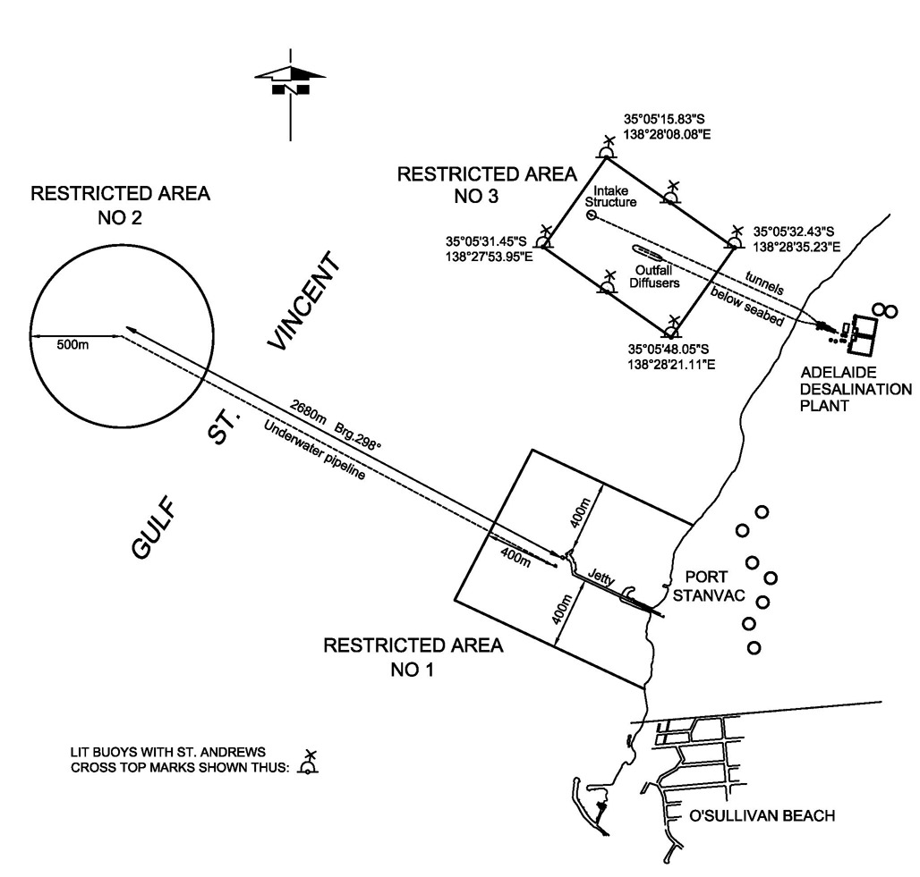
Port Stanvac
Area 1 : the portion of western Gulf St. Vincent bounded as follows:
• on the
north-east by a straight line 400 m north-east of the north extremity of the
Product Berth structure and parallel to the Approach Jetty;
• on the
south-east by a straight line 400 m south-west of the south-west side of
the Approach Jetty at Port Stanvac and parallel to the jetty;
• on the
north-west by a straight line at right angles to the north-east and south-west
boundaries and distant 400 m seaward (along the production of the
Approach Jetty) from the outermost extremity of the jetty;
• on the east by
the High Water Mark.
Area 2 : the portion of the waters of western Gulf St. Vincent at Port Stanvac
within a 500 m radius of the Single Buoy Mooring Facility in approximate
position latitude 35°05.9′ South,
longitude 138°26.3′ East.
Area 3: the portion of the waters of western Gulf St. Vincent at
Port Stanvac marked by six lit buoys with St. Andrews Cross top
marks and within the area bounded—
• on the
north-east by a straight line commencing at a point marked by a lit buoy at
latitude 35˚05′15.83″ South, longitude
138˚28′08.08″ East and extending south-east to a point marked
by a lit buoy at latitude 35˚05′32.43″ South, longitude
138˚28′35.23″ East; and
• on the
south-east by a straight line commencing at a point marked by a lit buoy at
latitude 35˚05′32.43″ South, longitude
138˚28′35.23″ East and extending south-west to a point marked
by a lit buoy at latitude 35˚05′48.05″ South, longitude
138˚28′21.11″ East; and
• on the
south-west by a straight line commencing at a point marked by a lit buoy at
latitude 35˚05′48.05″ South, longitude
138˚28′21.11″ East and extending north-west to a point marked
by a lit buoy at latitude 35˚05′31.45″ South, longitude
138˚27′53.95″ East; and
• on the
north-west by a straight line commencing at a point marked by a lit buoy at
latitude 35˚05′31.45″ South, longitude
138˚27′53.95″ East and extending north-east to a point marked
by a lit buoy at latitude 35˚05′15.83″ South, longitude
138˚28′08.08″ East.
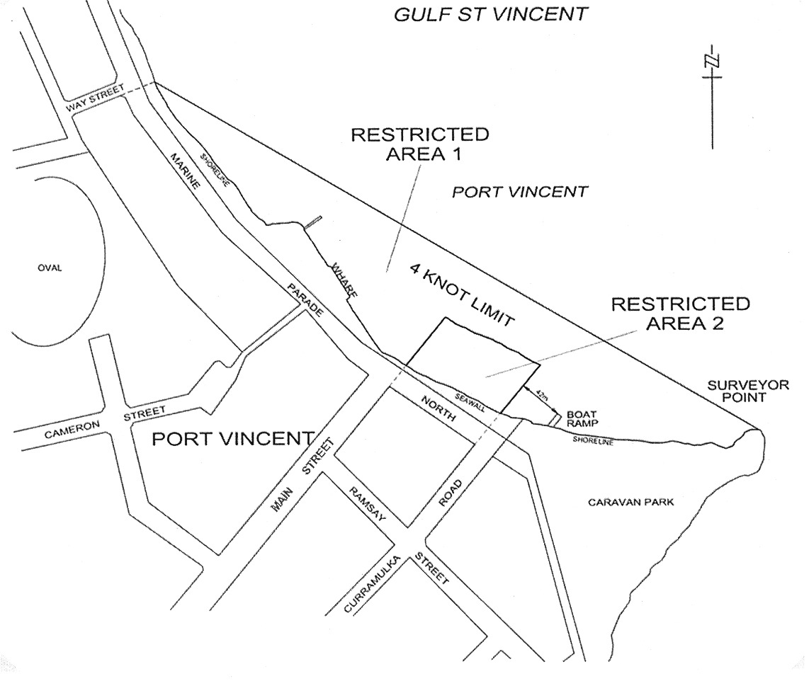
Port Vincent
Area 1 : the portion of the waters of Gulf St. Vincent at Port Vincent
bounded as follows:
• on the
north-east by a straight line joining Surveyor Point with a point being the
intersection of the edge of the water and the prolongation seaward of the
south-eastern boundary of Way Street;
• on the
south-west by the edge of the water, the face of the wharf and the
north-western, north-eastern and south-eastern boundaries of Area 2.
Area 2 : the portion of the waters of Gulf St. Vincent at Port Vincent bounded
as follows:
• on the
north-west by a straight line being the prolongation seaward of the
south-eastern boundary of Main Street;
• on the
north-east by a line 60 m seaward of, and parallel to, the sea wall;
• on the
south-east by a straight line being the prolongation seaward of the
north-western boundary of Curramulka Road;
• on the
south-west by the edge of the water.
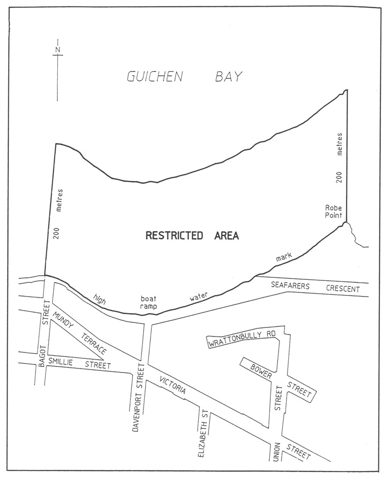
Robe
The portion of the sea at Robe bounded as follows:
• on the west by
a straight line being the production seaward of the western boundary of Bagot
Street;
• on the east by
a straight line extending seaward in a northerly direction from Robe Point;
• on the south
by the High Water Mark;
• on the north
by a line approximately 200 m seaward of, and parallel to, the High Water
Mark.
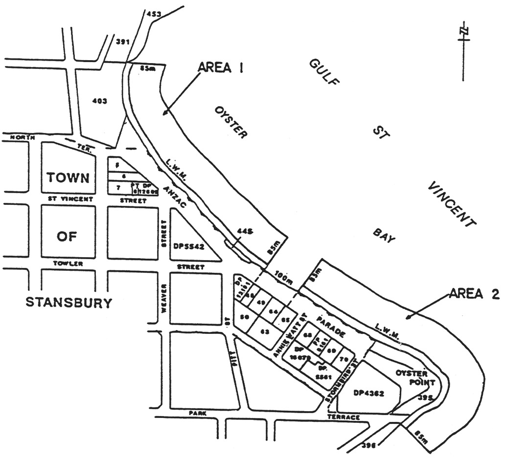
Stansbury
Area 1 : the portion of the waters of the sea at Stansbury delineated on the
plan below as Area 1;
Area 2 : the portion of the waters of the sea at Stansbury delineated on the
plan below as Area 2.
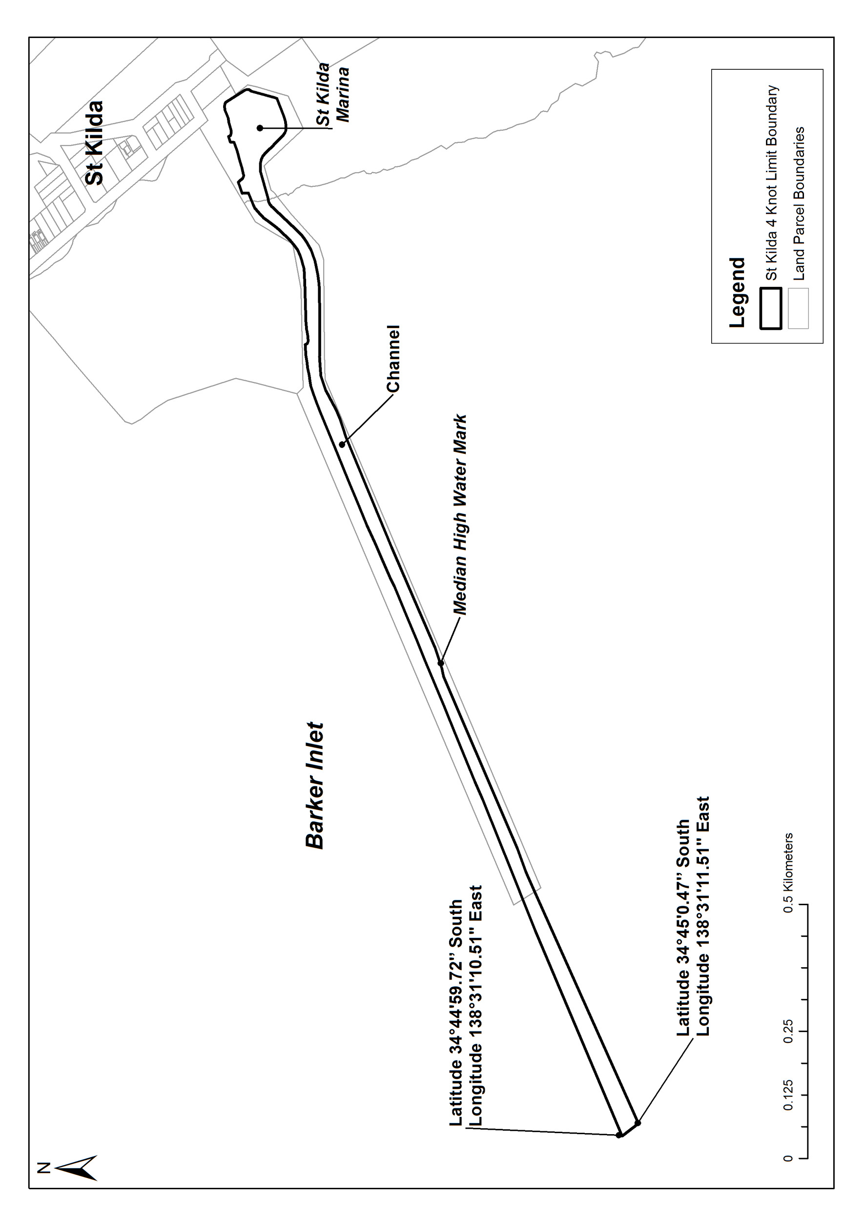
St. Kilda
The waters within the St. Kilda Marina and the channel out to the St. Kilda
entrance beacon located at latitude 34°44'59.72" South,
longitude 138°31'10.51" East and the starboard lateral beacon
located at latitude 34°45'0.47" South, longitude
138°31'11.51" East.
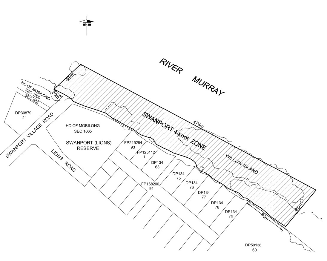
Swanport
The portion of the River Murray at Swanport bounded as follows:
• on the
north-west, by a straight line extending 65 m in a north-easterly direction
from a point at the water's edge 20 m upstream of the point at which the
north-western boundary of Swanport Village Road (or the prolongation of that
boundary) meets the water's edge and parallel to that boundary;
• on the
south-east, by a straight line extending 85 m in a north-easterly direction
from a point at the water's edge 80 m downstream of the point at which the
south-eastern boundary of Lot 79 of Deposited Plan No 134 (or the
prolongation of that boundary) meets the water's edge and parallel to that
boundary;
• on the
north-east, by a straight line joining the northern extremity of the
north-western boundary with the northern extremity of the south-eastern
boundary;
• on the
south-west, by the water's edge.
Swan Reach
The portion of the River Murray at Swan Reach bounded as follows:
• on the
north-east by a straight line, marked by yellow spherical buoys, being the
prolongation north-westerly of the north-east boundary of Section 352,
Hundred of Nildottie, extending 10 m north-westerly from the river edge;
• on the
south-west by a straight line, 20 m from and parallel to the
north-eastern boundary, extending 10 m north-westerly from the river
edge;
• on the
north-west by a straight line, marked by yellow spherical buoys, joining the
north-west extremities of the south-west and north-east boundaries;
• on the
south-east by the river edge.

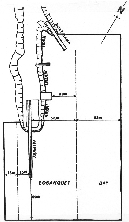
Thevenard
The portion of the sea at Bosanquet Bay delineated in bold on the plan below:
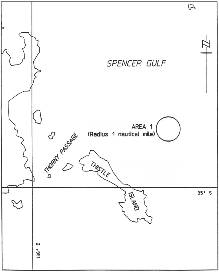
Thistle Island
Area 1 : the portion of the waters of Spencer Gulf bounded by a circle of
radius 1 nautical mile centred on a point at
latitude 34°55.9′ South, longitude 136°14.05′
East.
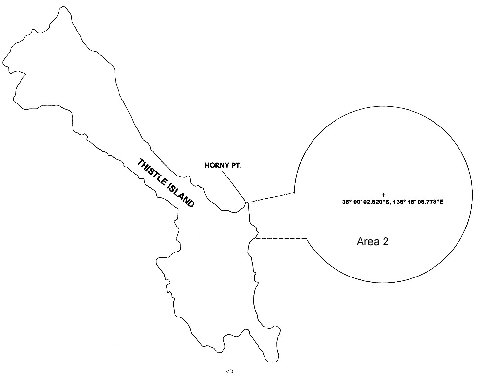
Area 2 : the portion of the waters of Spencer Gulf bounded as follows:
commencing at the High Water Mark near Horny Point at a point at
latitude 35°00′13.860″ South,
longitude 136°11′23.744″ East, then east-north-east in a
straight line to a point at latitude 35°00′00.000″
South, longitude 136°12′42.495″ East, being the
intersection of that line with the western circumference of a circle of radius
2 nautical miles centred on a point at
latitude 35°00′02.280″ South,
longitude 136°15′08.778″ East, then clockwise from that
intersection around the circumference to a point on the western circumference
of the circle at latitude 35°01′02.251″ South,
longitude 136°13′01.891″ East, then west in a straight
line to the High Water Mark at latitude 35°01′02.251″
South, longitude 136°11′36.068″ East, then north along
the High Water Mark to the point of commencement (all positions being in the
WGS84 datum).
Tumby Bay
Area 1 : the portion of the sea at Tumby Bay bounded as follows:
• on the north
by a straight line being the prolongation seawards of the south boundary of
Elanora Avenue for a distance of 100 m from the High Water Mark;
• on the east by
a straight line joining the seaward extremity of the north boundary and the
north-east corner of the old jetty;
• on the
north-east by a straight line joining the north-east corner of the old jetty
and the north-east corner of the new jetty;
• on the east by
the seaward end of the new jetty;
• on the south
by the south side of the new jetty;
• on the west by
the High Water Mark.
Area 2 : the area of the sea at Tumby Bay bounded as follows:
• on the
south-west by a line parallel to and 100 m seaward from the High Water
Mark;
• on the east by
a straight line commencing at a point 50 m west of the east extremity of
Section 354, Hundred of Hutchison, and extending due north for 450 m
from the south-west boundary;
• on the north
by a straight line commencing at a point 2 km generally north-westerly
along the south-west boundary from the east boundary, and extending due east
for 450 m from the south-west boundary;
• on the
north-east by a straight line joining the seaward extremities of the
south-west and east boundaries.
Area 3 : the area of the sea at Tumby Bay bounded as follows:
• on the south
by a straight line extending due east from a point 1.2 km along the High
Water Mark and generally north-west from the east extremity of
Section 354, Hundred of Hutchison;
• on the west by
a straight line extending due north from a point 100 m along the High
Water Mark and generally north-west from the west extremity of the south
boundary;
• on the
north-east by the south-west boundary of Area 2.
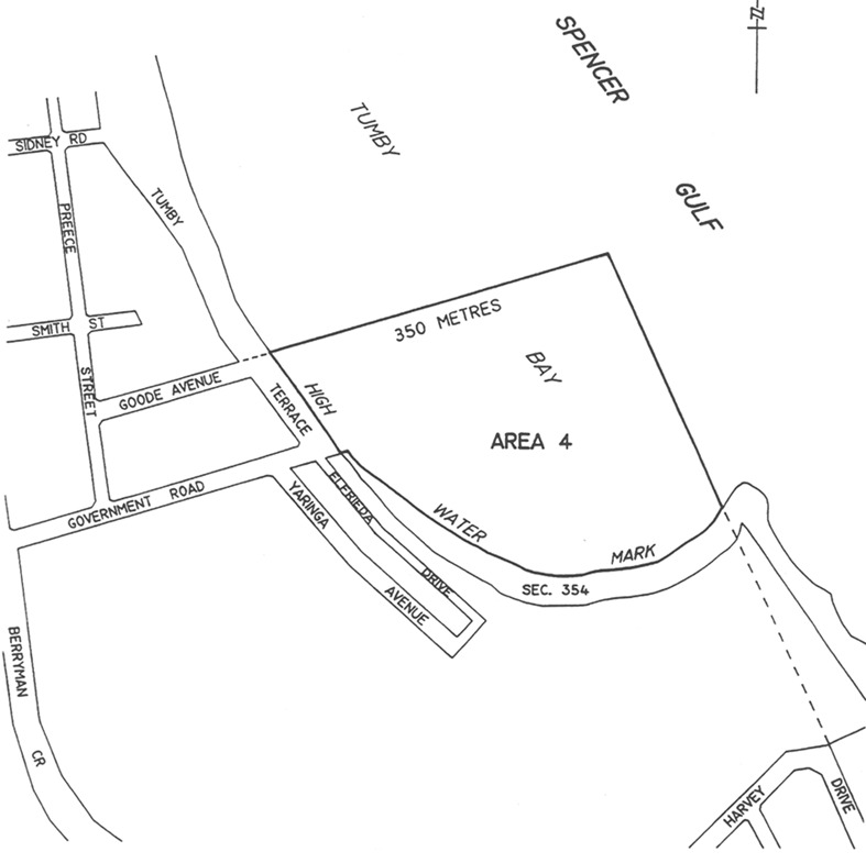
Area 4 : the area of the sea at Tumby Bay bounded as follows:
• on the west
and south by the High Water Mark;
• on the north
by a straight line being the prolongation seawards of the northern boundary of
Goode Avenue for a distance of 350 m from the High Water Mark;
• on the east by
a straight line being the prolongation seawards of the eastern boundary of
Harvey Drive in a northerly direction joining the seaward extremity of the
north boundary.
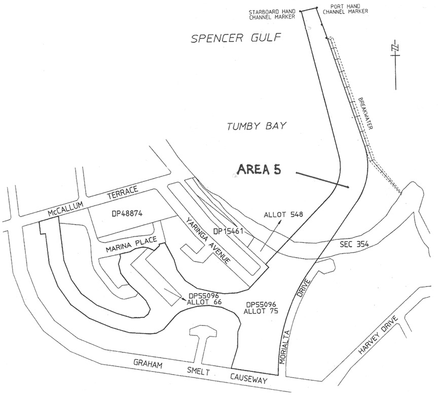
Area 5 : the area of the sea at Tumby Bay bounded as follows:
commencing at the northern most starboard hand channel marker of the marked
navigation channel leading to the Tumby Bay Marina, then generally easterly
across the marked navigation channel to the northern most port hand channel
marker of the marked navigation channel, then generally south-easterly along
the eastern edge of the marked navigation channel to its intersection with the
breakwater, then generally south-easterly along the western edge of the
breakwater to the point at which there is a bend in the breakwater, then
generally south-westerly along the eastern edge of marked navigation channel
to its intersection with the north-eastern corner of Allotment 75 in
Deposited Plan No 55096, then generally southerly, westerly and easterly
around the boundary of that Allotment (including Allotment 66 in
Deposited Plan No 55096) to its intersection with the north-eastern
corner of Allotment 548 in Deposited Plan No 15461, then generally
north-easterly and northerly along the western edge of the marked navigation
channel to the point of commencement.

Valley Lake
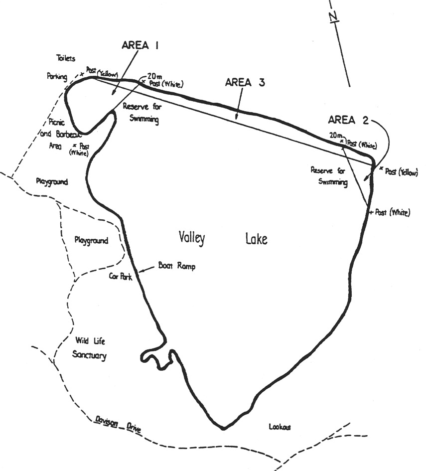
Area 1 : the portion of Valley Lake bounded on the south-east by a straight
line extending south-west from the white marker post situated approximately
midway along the north shore of Valley Lake to the white marker post situated
on the west shore of Valley Lake.
Area 2 : the portion of Valley Lake bounded on the west by a straight line
from the white marker post situated near the east end of the north shore of
Valley Lake to the white marker post on the east shore of Valley Lake.
Area 3 : the portion of Valley Lake not included in Area 1 or 2 bounded
on the south-west by a straight line extending south-east from the yellow
marker post situated on the north shore of Valley Lake to the yellow marker
post situated on the shore at the approximate north-east corner of Valley
Lake.
Victor Harbor
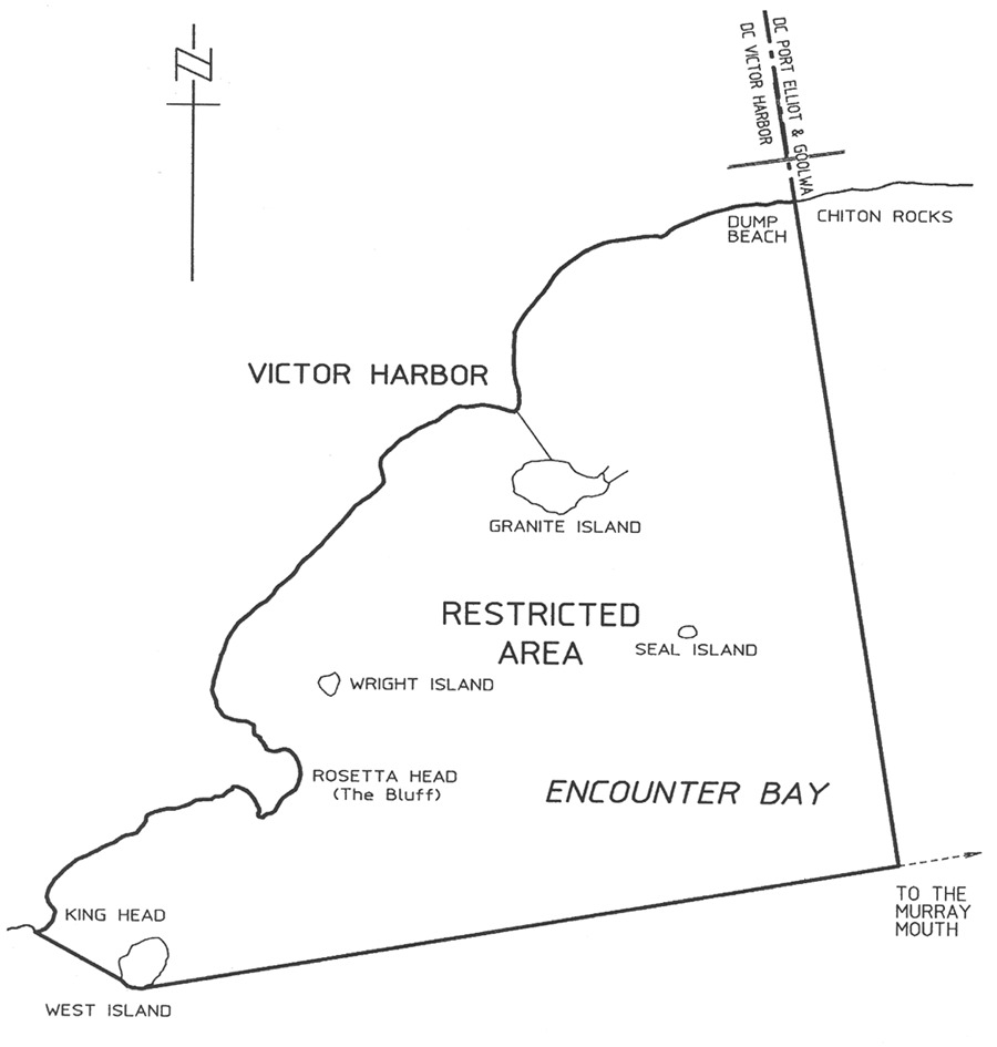
The portion of the sea at Victor Harbor bounded as follows:
• on the west by
a line joining the most southerly point of King Head to the most southerly
point of West Island;
• on the south
by a line commencing at the most southerly point of West Island and then
proceeding generally eastward towards the Murray mouth to a point where the
line intersects at right angles with the prolongation, generally south and to
seaward, of the easterly boundary of the area of the City of Victor Harbor;
• on the east by
the prolongation, generally south and to seaward, of the easterly boundary of
the area of the City of Victor Harbor (ie the eastern side of Ocean Road, Port
Elliot);
• on the north
by the High Water Mark of the coastline between the easterly boundary of the
area of the City of Victor Harbor (ie the eastern side of Ocean Road, Port
Elliot) and the most southerly point of King Head.
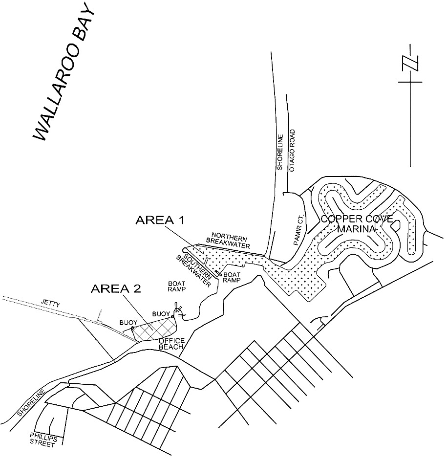
Wallaroo Bay
Area 1 : the portion of the waters of the sea at Wallaroo described as
"Area 1" on the plan below.
Area 2 : the portion of the waters of the sea at Wallaroo described as
"Area 2" on the plan below.
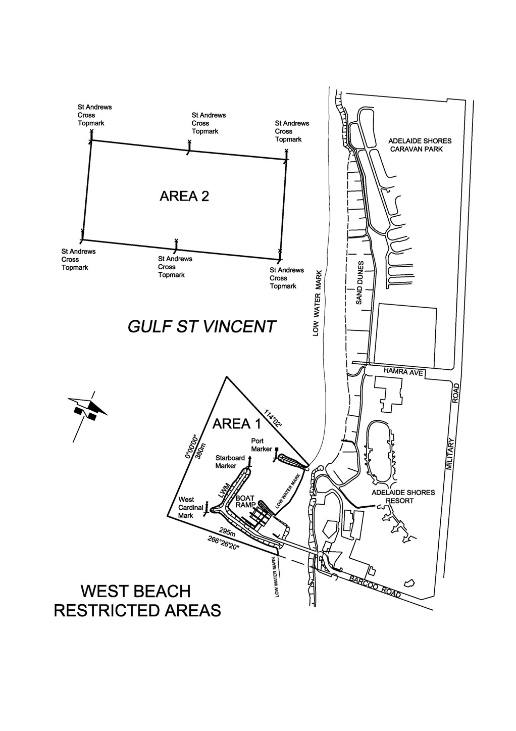
West Beach
Area 1: the portion of the waters of Gulf St. Vincent at West Beach
bounded as follows:
commencing at a point being the intersection of the production of the southern
boundary of Barcoo Road and the Low Water Mark, then seaward for a distance of
295 m along that prolongation, then northerly for a distance of
380 m, then generally south-easterly on a bearing of 114°02′
to its intersection with the Low Water Mark, then generally westerly,
southerly and easterly along the Low Water Mark around the breakwaters and the
boat ramp to the point of commencement.
Area 2 : the portion of the waters of Gulf St. Vincent at West Beach
bounded as follows:
• commencing on
the north approximately 140 m from the High Water Mark of the coast to
the St. Andrews Cross navigational marker at latitude
34°57′01.08″ South, longitude
138°30′04.76″ East and extending seaward in a westerly
direction for approximately 500 m to the St. Andrews Cross
navigational marker at latitude 34°57′05.44″ South,
longitude 138°29′46.13″ East;
• on the west by
a straight line drawn in a generally southerly direction from latitude
34°57′05.44″ South, longitude
138°29′46.13″ East to the St. Andrews Cross navigational
marker at latitude 34°57′13.24″ South, longitude
138°29′48.93″ East;
• on the south
by a straight line drawn in a generally easterly direction from latitude
34°57′13.24″ South, longitude
138°29′48.93″ East to the St. Andrews Cross navigational
marker at latitude 34°57′08.84″ South, longitude
138°30′07.81″ East;
• on the east
from latitude 34°57′08.84″ South, longitude
138°30′07.81″ East and parallel to the High Water Mark to the
point of commencement at the St. Andrews Cross navigational marker at
latitude 34°57′01.08″ South, longitude
138°30′04.76″ East.
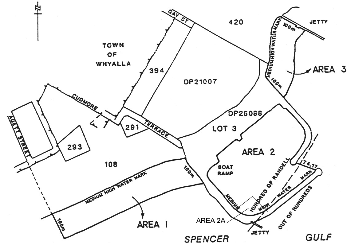
Whyalla
Area 1 : the portion of Spencer Gulf at Whyalla bounded as follows:
• on the
south-west by a line being the prolongation of the western side of Agett
Street, Town of Whyalla, seawards from the High Water Mark for a distance of
100 m;
• on the
north-east commencing at the south-eastern corner of Section 108, Hundred
of Randell, then south-westerly along the High Water Mark for 100 m;
• on the
south-east by a line joining the south-eastern extremities of the south-west
and north-east boundaries and parallel to the High Water Mark;
• on the
north-west by the High Water Mark.
Area 2 : the portion of Spencer Gulf at Whyalla bounded as follows, but
excluding the area defined as Area 2A:
commencing at the most westerly point on the north-eastern tip of the southern
breakwater (being portion of Lot 3 in Deposited Plan No 26088); then
west-north-westerly along a line of bearing 290°14′10″ for a
distance of 74.17 m to intersect with the High Water Mark on the northern
breakwater; then following the High Water Mark along the inside of the boat
haven to the point of commencement.
Area 2A : the portion of Spencer Gulf at Whyalla bounded as follows:
commencing at a point on the northern face of the southern breakwater (being
portion of Lot 3 in Deposited Plan No 26088), being a point that is
246 m (measured along the northern face of the southern breakwater) from
the most westerly point on the north-eastern tip of the southern breakwater;
then generally north-westerly for a distance of 77 m; then south-westerly
for a distance of 87 m to the northern face of the southern breakwater,
being the area bounded by yellow buoys.
Area 3 : the portion of Spencer Gulf at Whyalla bounded as follows:
commencing at the intersection of the High Water Mark and the south-western
side of the jetty adjacent to Section 420, Hundred of Randell; then
south-easterly along the southern side of the jetty for 100 m; then
generally south-westerly along a line parallel to and 100 m seawards of
the High Water Mark to its intersection with the northern breakwater (part of
Lot 3, Deposited Plan No 26088); then generally north-westerly and
northerly along the High Water Mark to the point of commencement.
Area 4 : the portion of False Bay at Whyalla described as "Area 4" on the
plan below.
Area 5 : the portion of False Bay at Whyalla described as "Area 5" on the
plan below.

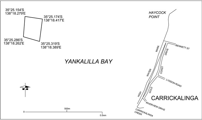
Yankalilla Bay
The portion of the waters of Yankalilla Bay at Carrickalinga bounded as
follows:
• on the north
by a straight line drawn in a generally easterly direction from
latitude 35°25.154′ South,
longitude 138°18.279′ East and extending approximately
200 m to latitude 35°25.174′ South,
longitude 138°18.417′ East;
• on the east by
a straight line drawn in a generally southerly direction from
latitude 35°25.174′ South,
longitude 138°18.417′ East and extending approximately
200 m to latitude 35°25.319′ South,
longitude 138°18.389′ East;
• on the south
by a straight line drawn in a generally west-north-westerly direction from
latitude 35°25.319′ South,
longitude 138°18.389′ East and extending approximately
200 m to latitude 35°25.286′ South,
longitude 138°18.262′ East;
• on the west by
a straight line drawn in a generally northerly direction from
latitude 35°25.286′ South,
longitude 138°18.262′ East and extending approximately
200 m to latitude 35°25.154′ South,
longitude 138°18.279′ East.
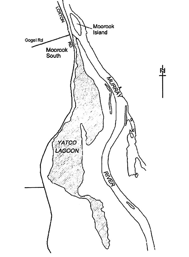
Yatco Lagoon
The whole of Yatco Lagoon being the body of water to the south of a straight
line commencing at the point at which the prolongation easterly of the
northern boundary of Gogel Road meets the waters edge and extending
south-easterly to the northernmost point of the headland immediately to the
south of Moorook Island.
Part 2—Identification of controls
In this Schedule, a reference to a control of a particular number is a
reference to the regulation, restriction or prohibition of the relevant number
listed below:
1. a person must not
take a vessel into the specified waters or cause or permit a vessel to enter
or remain in the specified waters;
2. a person must not
operate a vessel fitted with an engine in the specified waters at a speed in
excess of 4 knots or in a planing attitude;
3. a person must not
operate a vessel in the specified waters at a speed in excess of 4 knots
or in a planing attitude;
4. a person must not
ski, aquaplane or be towed in any other manner by a vessel in the specified
waters;
5. a person must not
ski, aquaplane or be towed in any other manner by a vessel in specified waters
at a speed in excess of 4 knots;
6. a person must not
swim, bathe or dive (including scuba dive) in the specified waters;
7. a person must not
swim, bathe or dive (including scuba dive) in the specified waters except for
purposes connected with water skiing, aquaplaning or like activity;
8. a person must not
swim or bathe in the specified waters except for purposes connected with scuba
diving or snorkelling;
9. a person must not
operate a vessel fitted with an engine in the specified waters;
10. a person must not
operate a vessel fitted with an engine in the specified waters during the
period between 1 October and 1 April (inclusive) in any year;
11. a person must not
operate a vessel in the specified waters except for the purposes of water
skiing, aquaplaning or like activity;
12. a person must not
leave any fishing apparatus unattended in the specified waters;
13. a person must not
moor a vessel, fish or trawl in the specified waters;
14. a person must not
moor a vessel in the specified waters except at a permanent mooring facility
established in the waters;
15. a person must not
remove or interfere with a wreck or any part of a wreck in the specified
waters;
16. a person must
not—
(i)
operate a vessel other than a personal watercraft; or
(ii)
swim, bathe or dive (including scuba dive) except for
purposes connected with operating a personal watercraft,
in the specified waters;
17. a person must not
operate a personal watercraft in the specified waters during the period
between 1 May and 30 September (inclusive) in any year;
18. a person must not
operate a vessel fitted with an engine in the specified waters at any time
between sunrise and sunset on any day during the period between
1 December and 31 March (inclusive) in any year.
Part 3—Controls applying in particular areas
3—Controls applying in particular areas
The controls applying in particular restricted areas are as follows:
|
Controls applying in the area(s) |
Additional controls applying in the area(s) Editorial Note— It is also an offence to contravene these controls—see
regulation 10. | |
|---|---|---|
|
Angas Inlet |
Controls 1 and 4 Editorial Note— see clause 4 below. | |
|
Ardrossan Area 1 |
Controls 1 and 4 | |
|
Ardrossan Area 2 |
Control 2 | |
|
Balgowan Areas 1 and 2 |
Controls 3 and 5 | |
|
Black Point |
Controls 3 and 5 | |
|
Blackfellow's Caves Area 1 |
Controls 3 and 5 | |
|
Blackfellow's Caves Area 2 |
Controls 1 and 4 | |
|
Blanchetown |
Controls 3 and 5 | |
|
Blanchetown Area 2 |
Controls 2 and 5 | |
|
Brighton Areas 1 to 4 |
Control 9 | |
|
Brighton Area 5 |
Control 9 | |
|
Bucks Bay |
Controls 1 and 4 | |
|
Caloote Landing Area 1 |
Controls 1 and 4 | |
|
Caloote Landing Area 2 |
Controls 3 and 5 | |
|
Christies Beach |
Control 13 | |
|
Clayton Bay |
Controls 1 and 4 | |
|
Currency Creek |
Control 2 | |
|
East Wellington |
Controls 2 and 5 | |
|
Fisherman Bay |
Controls 2 and 5 | |
|
Fleurieu Reef |
Controls 3, 4, 8, 14 and 15 | |
|
Forbys Island |
Controls 1 and 4 | |
|
Glenelg Area 1 |
Controls 3 and 5 | |
|
Glenelg Area 2 |
Controls 3 and 5 | |
|
Glenelg Area 3 |
Controls 1, 4 and 9 | |
|
Glenelg River |
Controls 3 and 5 | |
|
Goolwa Areas 1, 3 and 5 |
Controls 3 and 5 | |
|
Goolwa Areas 2, 4 and 6 |
Controls 2 and 5 | |
|
Goolwa Area 7 |
Control 16 | |
|
Goolwa Area 8 |
Controls 2 and 4 | |
|
Henley Beach |
Control 18 | |
|
Hog Bay |
Controls 1 and 4 | |
|
Kellidie Bay |
Controls 3 and 5 | |
|
Lake Bonney (Barmera Area 1) |
Controls 1 and 4 | |
|
Lake Bonney (Barmera Area 2) |
Controls 2 and 5 | |
|
Lake Bonney (South East) |
Controls 1, 4 and 6 | |
|
Lake Fellmongery Area 1 |
Control 9 |
A person must not operate a vessel that is not fitted with an engine at a
speed in excess of 4 knots or in a planing attitude. |
|
Lake Fellmongery Area 2 |
Controls 1 and 4 | |
|
Lake Fellmongery Area 3 |
Controls 7 and 11 |
A person must not— (a)
operate a vessel at a speed in excess of 35 knots; or (b)
operate a vessel or engage in water skiing, aquaplaning or like activity
before 8 am or after sunset or 8 pm (whichever is the earlier) on any day; or (c)
operate a vessel or engage in water skiing, aquaplaning or like activity if
there are already 8 vessels within the area. If there are 8 vessels within the area and others waiting to use the
area— (a) a
vessel must not remain in the area for more than 30 minutes at any one time;
and (b)
unless otherwise agreed by the operators of all the vessels, vessels must
enter the area in the order of their arrival at the area and then rotate turns
in the same order. |
|
Lake Leake |
Controls 1 and 4 | |
|
Mannum Areas 1 and 2 |
Controls 1 and 4 | |
|
Mannum Area 3 |
Controls 3 and 5 | |
|
Meningie Area 1 |
Controls 1 and 4 | |
|
Meningie Area 2 |
Controls 2 and 5 | |
|
Milang |
Controls 1 and 4 | |
|
Moana |
Controls 4 and 9 | |
|
Morgan and Cadell Areas 1 and 2 |
Controls 1 and 4 | |
|
Murray Bridge Area 1 |
Controls 3 and 5 | |
|
Murray Bridge Area 2 |
Control 9 Editorial Note— see clause 8 below. |
In this area the river is divided into 2 channels and the usual rules of
navigation apply in respect of each of those channels. |
| | | |
|
Murray Bridge (bathing) Areas 1 to 7 |
Controls 1 and 4 | |
|
Nildottie |
Controls 2 and 5 | |
|
North Haven Marina |
Control 2 | |
|
North Shields |
Controls 3 and 5 | |
|
O'Sullivan Beach |
Controls 2 and 6 | |
|
Point Turton Area 1 |
Controls 1 and 4 | |
|
Point Turton Area 2 |
Control 2 | |
|
Port Adelaide |
Control 12 | |
|
Port Bonython Zone 1 |
Controls 1 and 4 | |
|
Port Bonython Zone 2 |
Controls 1 and 4, but only while either or both of the following
apply: | |
| |
(a) a
vessel is moored at the jetty; | |
| |
(b) the
berth operations signals at the seaward end of the jetty are signalling a
single red light flashing at an approximate rate of 1 flash every
2 seconds. | |
|
Port Bonython Zone 3 |
Controls 1 and 4, but only while either or both of the following
apply: (a) an
audible signal is sounding; (b) the
berth operations signals at the seaward end of the jetty are signalling a
single red light flashing at an approximate rate of 2 flashes per second.
| |
|
Port Elliot |
Control 2 | |
|
Porter Bay |
Controls 2 and 5 | |
|
Port Hughes |
Control 6 | |
|
Port Neill |
Controls 2 and 5 | |
|
Port Stanvac Areas 1 and 2 |
Controls 1 and 4 | |
|
Port Stanvac Area 3 |
Controls 1, 4 and 6 | |
|
Port Vincent Area 1 |
Controls 3 and 5 | |
|
Port Vincent Area 2 |
Control 10 | |
|
Robe |
Controls 3 and 5 | |
|
Stansbury Areas 1 and 2 |
Controls 3 and 5 | |
|
St. Kilda |
Controls 2 and 6 | |
|
Swanport |
Controls 2 and 5 | |
|
Swan Reach |
Controls 1 and 4 | |
|
Thevenard |
Control 6 | |
|
Thistle Island Areas 1 and 2 |
Control 13 Editorial Note— see clause 7 below. | |
|
Tumby Bay Areas 1 and 4 |
Controls 2 and 5 | |
|
Tumby Bay Areas 2 and 3 |
Control 7 | |
|
Tumby Bay Area 5 |
Controls 3 and 5 | |
|
Valley Lake Areas 1, 2 and 3 |
Controls 1 and 4 | |
|
Victor Harbor |
Control 17 | |
|
Wallaroo Bay Area 1 |
Controls 2, 4 and 6 | |
|
Wallaroo Bay Area 2 |
Controls 1 and 4 | |
|
West Beach Area 1 |
Controls 4 and 6 | |
|
West Beach Area 2 |
Controls 1, 4 and 9 | |
|
Whyalla Areas 1 and 3 |
Control 9 | |
|
Whyalla Area 2 |
Controls 3 and 5 | |
|
Whyalla Area 2A |
Control 1 | |
|
Whyalla Areas 4 and 5 |
Controls 1 and 4 | |
|
Yankalilla Bay |
Controls 1, 4, 6, 12 and 13 | |
|
Yatco Lagoon |
Control 2 | |
4—Non-application of controls to certain vessels in Angas Inlet
The controls set out in the table in clause 3 in relation to Angas Inlet
do not apply in relation to vessels in the specified waters for a purpose
connected with the operation or maintenance of Torrens Island Power Station.
5—Non-application of controls to certain vessels in Glenelg Area 3
and West Beach Area 2
The controls set out in the table in clause 3 in relation to Glenelg
Area 3 and West Beach Area 2 do not apply in relation to the
following vessels in the specified waters:
(a)
canoes, kayaks, surf skis, rowboats or other human-powered vessels;
(b)
vessels used for channel dredging;
(c)
survey vessels used by the Department of Environment and Natural Resources.
6—Non-application of controls to certain vessels at Henley Beach
The control set out in the table in clause 3 in relation to Henley Beach
does not apply to a person operating a vessel fitted with an engine that is in
the specified waters for the purposes of launching or retrieving a vessel by
use of the boat ramp near the Grange Sailing Club for a race or practice
involving rowing, sailing or other similar activity.
7—Non-application of controls to certain vessels in Lake Bonney (South
East)
The controls set out in the table in clause 3 in relation to Lake Bonney
(South East) do not apply in relation to a canoe, kayak, rowboat or other
similar human-powered vessel.
8—Non-application of controls to certain vessels in Murray Bridge
Area 2
The controls set out in the table in clause 3 in relation to Murray
Bridge Area 2 do not apply in relation to a vessel fitted with an engine
that is in the area because of its official association with a rowing, sailing
or similar race or practice.
9—Non-application of controls to certain vessels at Port Bonython, Port
Stanvac and Whyalla
(1) The controls set
out in the table in clause 3 in relation to the following
restricted areas:
(a) Port
Bonython Zone 1, 2 and 3;
(b) Port
Stanvac Areas 1 and 2;
(c)
Whyalla Areas 4 and 5,
do not apply in relation to vessels of the following classes:
(d)
vessels entering or remaining in the specified waters for the purposes of
loading or unloading at the port facilities;
(e)
vessels entering or remaining in the specified waters for purposes connected
with the operation of the port facilities or the harbor.
(2) The controls set
out in the table in clause 3 in relation to Port Stanvac Area 3
do not apply in relation to—
(a) a
person who is an employee, agent or contractor of AdelaideAqua Pty Limited or
the Environment Protection Authority and is carrying out duties or working in
that capacity in the specified waters; or
(b) a
vessel being used by a person referred to in paragraph (a) in the
specified waters.
10—Non-application of controls to certain vessels in Thistle Island
Areas 1 and 2
The controls set out in the table in clause 3 in relation to Thistle
Island Areas 1 and 2 do not apply in respect of the taking of abalone in
Thistle Island Area 2 in accordance with a licence under the Fisheries
Management Act 2007 .
11—Non-application of controls to certain vessels in Yankalilla Bay
(1) The controls set
out in the table in clause 3 in relation to Yankalilla Bay do not apply
in relation to a person or vessel in the specified waters—
(a) for
a purpose connected with the removal, salvage or maintenance of the prescribed
structure; or
(b)
performing official duties or functions relating to public health or safety,
or the environment, arising out of the presence of the prescribed structure in
the specified waters.
(2) In this
clause—
prescribed structure means the greenWAVE energy convertor (however described)
that is, on or after 18 September 2014, located within the restricted area in
Yankalilla Bay.
12—Expiry of certain provisions relating to Yankalilla Bay
(1) The following
provisions of this Schedule will expire on the prescribed day:
(a) the
entry in clause 1 relating to Yankalilla Bay;
(b) the
entry in the table in clause 3 relating to Yankalilla Bay;
(c)
clause 11;
(d) this
clause.
(2) In this
clause—
prescribed day means the day fixed by the Minister by notice in the Gazette as
the prescribed day.