
| South Australian Proclamations and Notices |
[Index] [Search] [Download] [Help]
Fisheries Management (Aquatic Reserves)
Proclamation 2007
under section 4 of the Fisheries Management Act 2007
This proclamation may be cited as the Fisheries Management (Aquatic
Reserves) Proclamation 2007.
This proclamation will come into operation on 1 December 2007.
3—Alteration of boundaries of
aquatic reserves
The boundaries of the aquatic reserves named in Schedule 1 are altered so
that the boundaries of those aquatic reserves are as specified in that
Schedule.
4—Constitution of Coobowie Aquatic
Reserve
The waters specified in Schedule 2 are declared to constitute an aquatic
reserve to which the name "Coobowie Aquatic Reserve" is assigned.
Notes—
1 All lines in spatial descriptions are geodesics based on the Geocentric
Datum of Australia 1994 (GDA94) as defined in the Commonwealth of Australia
Gazette GN35 of 6 September 1995 and all co-ordinates are
expressed in terms of GDA94.
2 The maps in the Schedules are provided for convenience of reference
only.
Schedule 1—Alteration of boundaries of aquatic
reserves
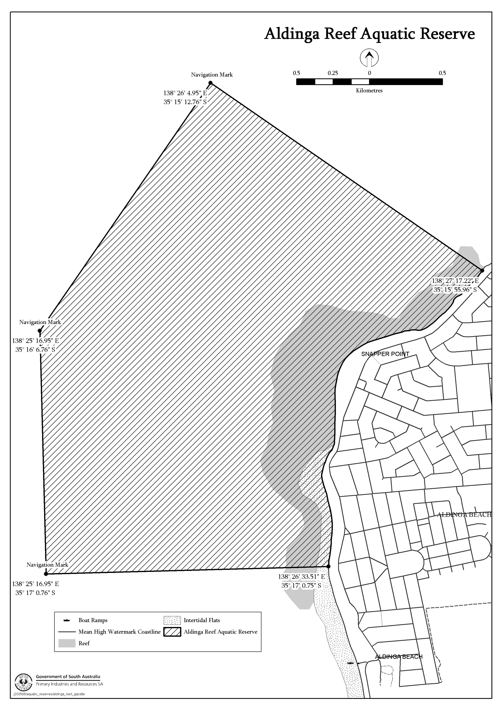
Aldinga Reef Aquatic Reserve
The waters of or near Aldinga Bay contained within and bounded by a line
commencing at Mean High Water Springs closest to 35°15'55.96" South,
138°27'17.22" East, then beginning south-westerly following the line of
Mean High Water Springs to the location closest to 35°17'00.75" South,
138°26'33.51" East, then westerly to 35°17'00.76" South,
138°25'16.95" East (Marine Navigation Mark 4730/610), then northerly to
35°16'06.76" South, 138°25'16.95" East (Marine Navigation Mark
4730/609), then north-easterly to 35°15'12.76" South,
138°26'04.95" East (Marine Navigation Mark 4730/608), then
south-easterly to the point of commencement.
American River Aquatic Reserve
The waters of American River upstream of the geodesic from the location on
Mean High Water Springs closest to 35°47'21.87" South, 137°45'35.16"
East to the location on Mean High Water Springs closest to 35°47'51.75"
South, 137°45'50.45" East (Picnic Point).

Bales Beach Aquatic Reserve
The waters of or near Bales Beach contained within and bounded by a line
commencing at Mean High Water Springs closest to 35°59'52.64" South,
137°19'28.96" East, then beginning easterly following the line of Mean High
Water Springs to the location closest to 36°00'57.68" South,
137°23'04.83" East, then southerly to a line 1000 metres seaward of Mean
High Water Springs closest to 36°01'30.05" South, 137°23'04.83" East,
then generally north-westerly following a line 1000 metres seaward of Mean
High Water Springs to the location closest to 36°00'24.98" South,
137°19'28.96" East, then northerly to the point of commencement.

Barker Inlet—St. Kilda Aquatic Reserve
The waters of or near Barker Inlet, easterly of the Grand Trunkway Road
Bridge near 34°48'32.52" South, 138°31'25.04" East and upstream of a
line commencing at Mean High Water Springs closest to 34°46'13.68" South,
138°31'21.37" East, then generally north-westerly contiguous with the
western extremity of the mangroves to the location closest to 34°45'25.78"
South, 138°30'33.12" East (Point Grey), then north-easterly contiguous with
the northern extremity of the mangroves to the Middle Ground Outer Beacon
(Marine Navigation Marker 3193/001) at the location closest to
34°45'08.08" South, 138°30'57.74" East, then north-easterly to
the St Kilda Entrance Beacon (Marine Navigation Marker 3193/003) at the location
closest to 34°44'59.73" South, 138°31'10.52" East, then north-easterly
to the south-western extremity of the St Kilda Channel embankment at the
location on Mean High Water Springs closest to 34°44'41.77" South,
138°31'56.55" East.

Blanche Harbour—Douglas Bank Aquatic Reserve
The waters of or near Blanche Harbor contained within and bounded by a line
commencing at Mean High Water Springs closest to 32°41'21.65" South,
137°45'20.84" East, then easterly to 32°41'20.19" South,
137°46'46.26" East (Channel Marker 4510/808), then south-easterly to
32°42'16.50" South, 137°47'16.81" East (Channel Marker 4510/806),
then south-easterly to 32°43'31.88" South, 137°49'25.61" East (Channel
Marker 4510/805), then southerly to 32°45'44.30" South,
137°49'18.52" East (Channel Marker 4510/802), then southerly to
32°48'30.34" South, 137°49'30.03" East (Channel Marker 4510/800),
then westerly to the location on Mean High Water Springs closest to
32°48'31.47" South, 137°48'13.41" East, then beginning
north-westerly following the line of Mean High Water Springs to the point of
commencement.

Goose Island Aquatic Reserve
The waters near Goose Island, Spencer Gulf, that lie within 200 metres of
the lines of Mean High Water Springs of Goose Island, Little Goose Island and
White Rock.

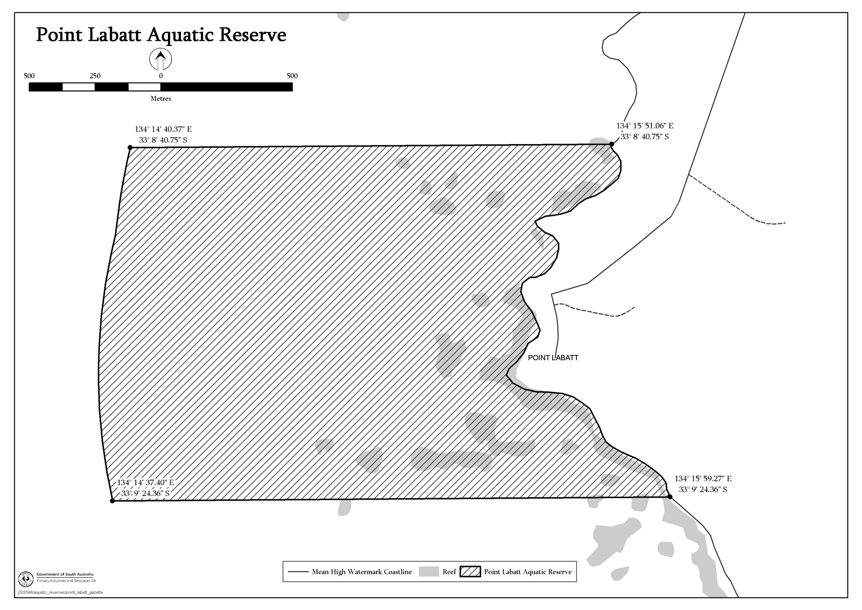
Point Labatt Aquatic Reserve
The waters of or near Point Labatt contained within and bounded by a line
commencing at Mean High Water Springs closest to 33°08'40.75" South,
134°15'51.06" East, then generally southerly following the line of Mean
High Water Springs to the location closest to 33°09'24.36" South,
134°15'59.27" East, then westerly to a line 1850 metres seaward of Mean
High Water Springs closest to 33°09'24.36" South,
134°14'37.40" East, then northerly following a line 1850 metres
seaward of Mean High Water Springs to the location closest to
33°08'40.75" South, 134°14'40.37" East, then easterly to the
point of commencement.
Port Noarlunga Reef Aquatic Reserve
The waters of or near Port Noarlunga contained within and bounded by a line
commencing at 35°07'56.56" South, 138°26'58.34" East, then easterly to
the location on Mean High Water Springs closest to 35°07'52.63" South,
138°28'11.09" East, then beginning southerly following the line of Mean
High Water Springs to the location closest to 35°11'05.18" South,
138°28'00.72" East (Robinson Point), then north-westerly to the point of
commencement, together with the waters of Onkaparinga River upstream to the
bridge on Main South Road at Noarlunga (D V Fleming Bridge) near
35°10'33.20" South, 138°29'55.31" East.

Seal Bay Aquatic Reserve
The waters of or near Seal Bay contained within and bounded by a line
commencing at Mean High Water Springs closest to 35°59'31.96" South,
137°17'01.03" East, then generally easterly following the line of Mean High
Water Springs to the location closest to 35°59'52.64" South,
137°19'28.96" East, then southerly to a line 1000 metres seaward of Mean
High Water Springs closest to 36°00'25.02" South,
137°19'28.96" East, then north-westerly following a line 1000 metres
seaward of Mean High Water Springs to the location closest to
36°00'04.34" South, 137°17'01.03" East, then northerly to
the point of commencement.

St Kilda—Chapman Creek Aquatic Reserve
The waters of or near St Kilda contained within and bounded by a line
commencing at Mean High Water Springs closest to 34°41'17.24" South,
138°27'35.26" East, then beginning south-easterly following the line of
Mean High Water Springs to the location closest to 34°44'41.77" South,
138°31'56.55" East, then south-westerly to 34°44'59.73" South,
138°31'10.52" East (Marine Navigation Marker 3193/003), then south-westerly
to 34°45'08.08" South, 138°30'57.74" East (Marine Navigation Marker
3193/001), then north-westerly to 34°41'36.75" South, 138°27'04.91"
East, then north-easterly to the point of commencement.

Troubridge Hill Aquatic Reserve
The waters of Investigator Strait contained within and bounded by a line
commencing at Mean High Water Springs closest to 35°09'21.74" South,
137°37'09.08" East (Suicide Point), then beginning south-easterly following
the line of Mean High Water Springs to the location closest to 35°10'04.99"
South, 137°39'12.70" East, then southerly to 35°11'04.45" South,
137°39'14.63" East, then north-westerly to 35°10'18.03" South,
137°37'10.82" East, then northerly to the point of commencement.

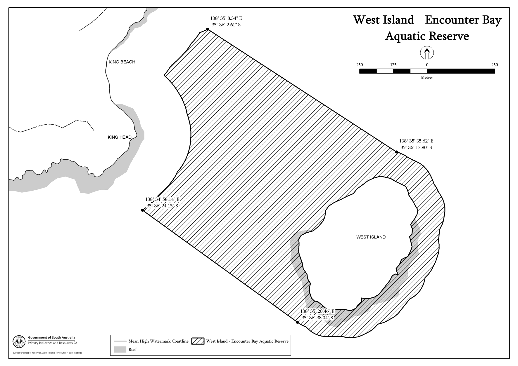
West Island Encounter Bay Aquatic Reserve
The waters near West Island contained within and bounded by a line
commencing at 200 metres seaward of Mean High Water Springs (King Beach)
closest to 35°36'02.61" South, 138°35'08.34" East, then south-easterly
to a line 100 metres seaward of Mean High Water Springs (West Island) closest to
35°36'17.90" South, 138°35'35.62" East, then beginning south-easterly
following a line 100 metres seaward of Mean High Water Springs (West Island) to
the location closest to 35°36'38.04" South, 138°35'20.46" East, then
north-westerly to a line 200 metres seaward of Mean High Water Springs (King
Head) closest to 35°36'24.15" South, 138°34'58.14" East, then
beginning north-easterly following a line 200 metres seaward of Mean High Water
Springs to the point of commencement.
Whyalla—Cowled’s Landing Aquatic Reserve
The waters of or near Whyalla contained within and bounded by a line
commencing at Mean High Water Springs closest to 33°04'26.61" South,
137°32'58.50" East, then easterly to 33°04'26.05" South,
137°33'24.19" East, then south-easterly to 33°05'12.75" South,
137°34'10.86" East, then south-westerly to 33°07'54.75" South,
137°31'52.86" East, then south-westerly to 33°09'12.76" South,
137°28'04.87" East, then westerly to the location on Mean High Water
Springs closest to 33°09'14.66" South, 137°26'35.17" East, then
generally north-easterly following the line of Mean High Water Springs to the
point of commencement.

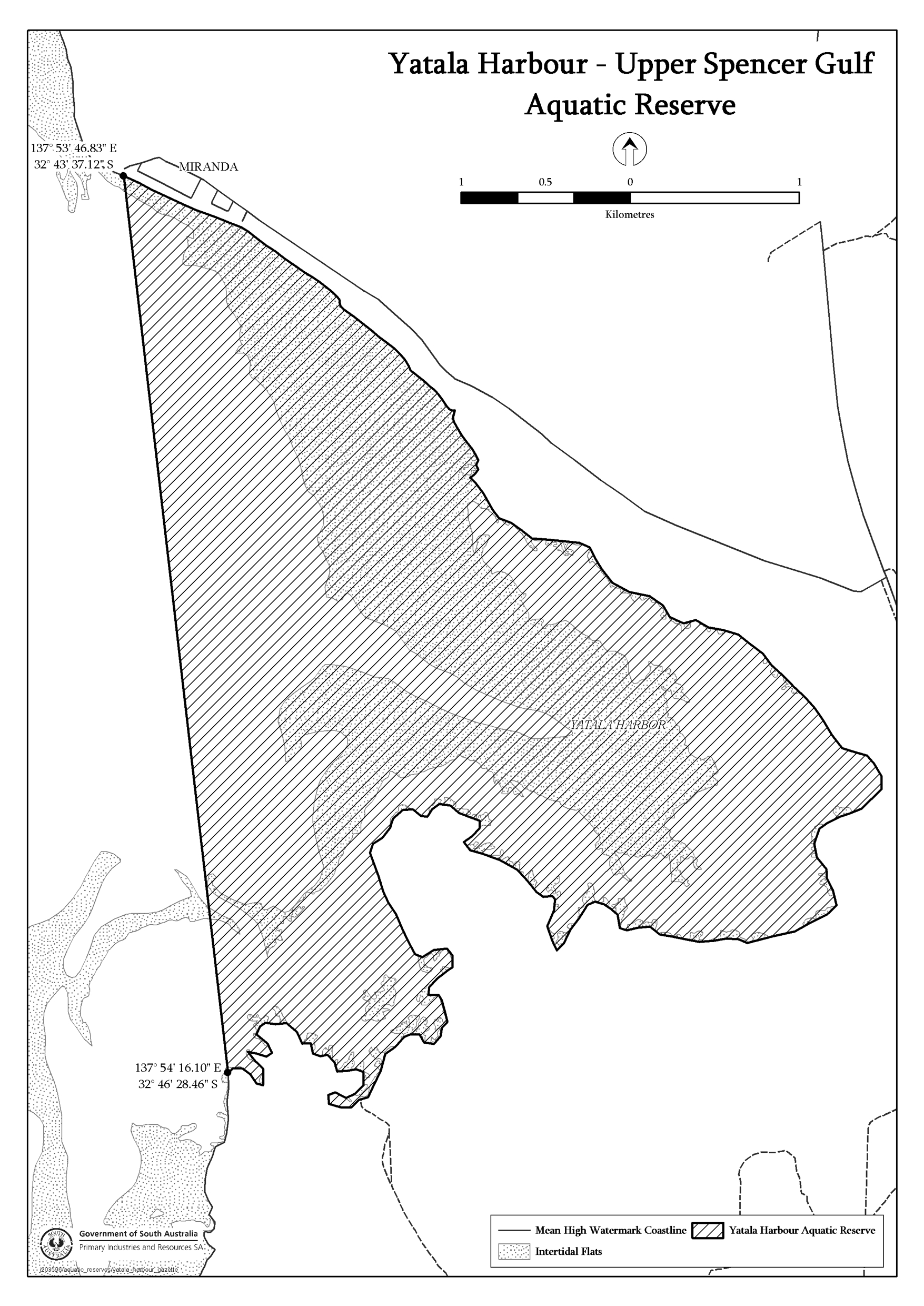
Yatala Harbour—Upper Spencer Gulf Aquatic Reserve
The waters of or near Yatala Harbor contained within and bounded by a line
commencing at Mean High Water Springs closest to 32°43'37.12" South,
137°53'46.83" East, then beginning south-easterly following the line of
Mean High Water Springs to the location closest to 32°46'28.46" South,
137°54'16.10" East, then north-westerly to the point of
commencement.
Schedule 2—Coobowie Aquatic
Reserve
The waters of or near Salt Creek Bay contained within and bounded by a line
commencing at Mean High Water Springs closest to 35°03'16.05" South,
137°43'47.88" East, then generally easterly following the line of Mean High
Water Springs to the location closest to 35°02'40.48" South,
137°45'31.20" East, then south-westerly to the point of
commencement.

Made by the Governor
with the advice and consent of the Executive Council
on 29 November
2007
MAFF07/026CS
[Published in the Gazette on 29 November 2007 at page 4386]