
| South Australian Proclamations and Notices |
[Index] [Search] [Download] [Help]
South Australia
Fisheries Management (Aquatic Reserves) Proclamation 2016
under section 4 of the Fisheries Management Act 2007
1—Short title
This proclamation may be cited as the Fisheries Management (Aquatic Reserves) Proclamation 2016.
2—Commencement
This proclamation will come into operation on the day on which the Fisheries Management (Aquatic Reserves) Regulations 2016
come into operation.
3—Abolition of aquatic reserves
The aquatic reserves named in Schedule 1
are abolished.
4—Alteration of boundaries of Coobowie Aquatic Reserve
The boundaries of the Coobowie Aquatic Reserve are altered so that the boundaries of that Reserve are as specified in Schedule 2
.
Schedule 1—Abolition of aquatic reserves
Aldinga Reef Aquatic Reserve
American River Aquatic Reserve
Bales Beach Aquatic Reserve
Blanche Harbour—Douglas Bank Aquatic Reserve
Goose Island Aquatic Reserve
Point Labatt Aquatic Reserve
Port Noarlunga Reef Aquatic Reserve
Seal Bay Aquatic Reserve
Whyalla—Cowled's Landing Aquatic Reserve
Yatala Harbour—Upper Spencer Gulf Aquatic Reserve
Schedule 2—Alteration of boundaries of Coobowie Aquatic Reserve
The waters of or near Salt Creek Bay contained within and bounded by a line commencing at Mean High Water Springs closest to 35°03′16.05″ South, 137°43′47.88″ East, then generally north-westerly following the line of Mean High Water Springs to the location closest to 35°03′15.22″ South, 137°43′40.37″ East (Beach Road), then generally north-westerly following the said road to the line of Mean High Water Springs closest to 35°3′9.39″ South, 137°43′38.81″ East, then beginning easterly following the line of Mean High Water Springs to the location closest to 35°02′40.48″ South, 137°45′31.20″ East, then south-westerly to the point of commencement, but excluding any land or waters so encompassed that lie landward of the line of Mean High Water Springs.
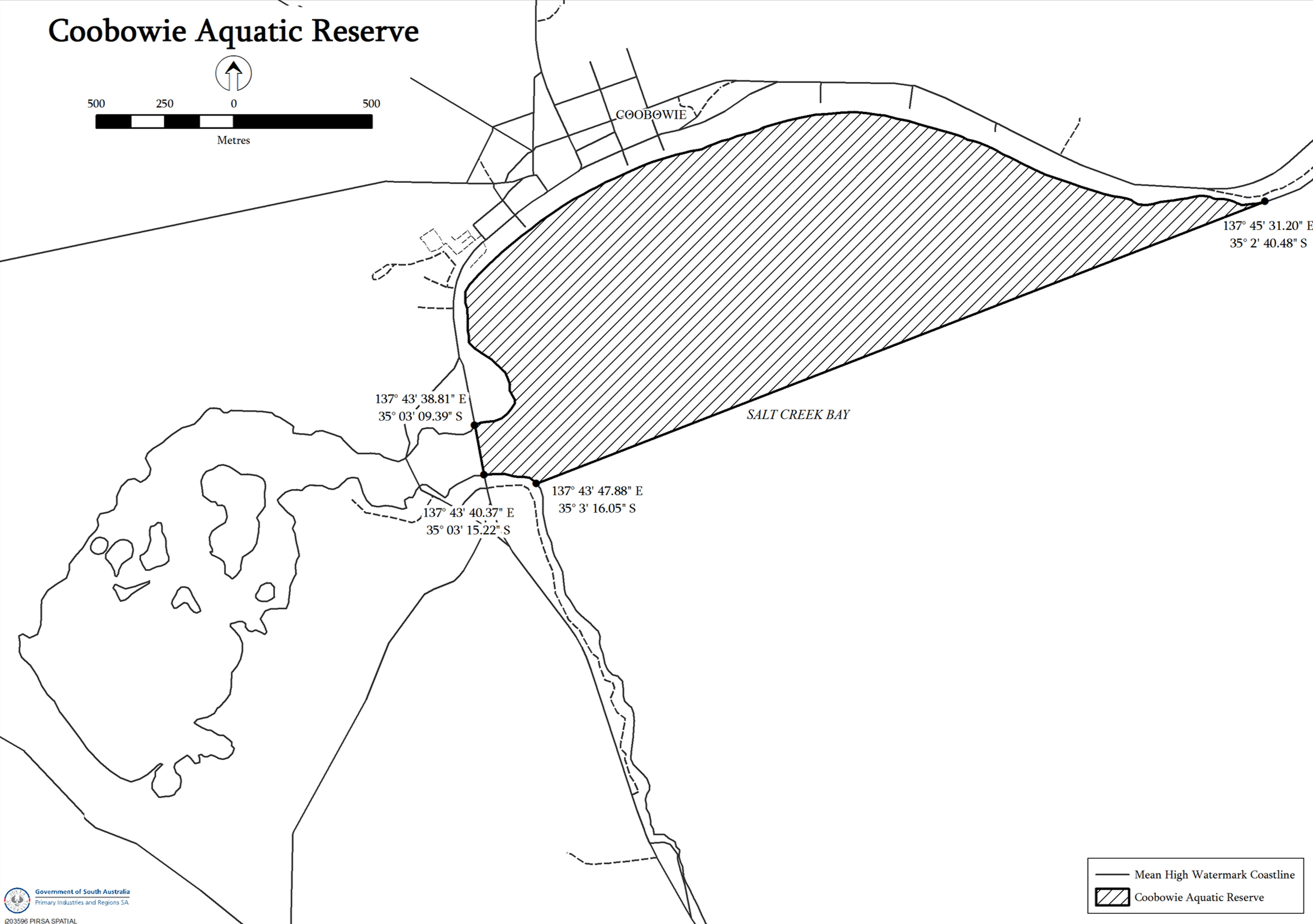
Notes—
1 All lines in the spatial description above are geodesics based on the Geocentric Datum of Australia 1994 (GDA94) as defined in the Commonwealth of Australia Gazette GN35 of 6 September 1995 and all co-ordinates are expressed in terms of GDA94.
2 The map above is provided for convenience of reference only.
Made by the Governor's Deputy
with the advice and consent of the Executive Council
on 20 October
2016
15MAFF039
[Published in the Gazette on 20 October 2016 at page 4071]