Western Australian Current Acts

[Index] [Table] [Search] [Search this Act] [Notes] [Noteup] [Previous] [Download] [Help]

ALUMINA REFINERY (MITCHELL PLATEAU) AGREEMENT ACT 1971 - FIFTH SCHEDULE

— Mitchell Plateau area

[s. 2]

        [Heading inserted: No. 31 of 2015 s. 7.]
Division 1 — Description

        [Heading inserted: No. 31 of 2015 s. 7.]

1.         Mitchell Plateau area

        (1)         In this clause —

        high water mark means ordinary high water mark at spring tides;

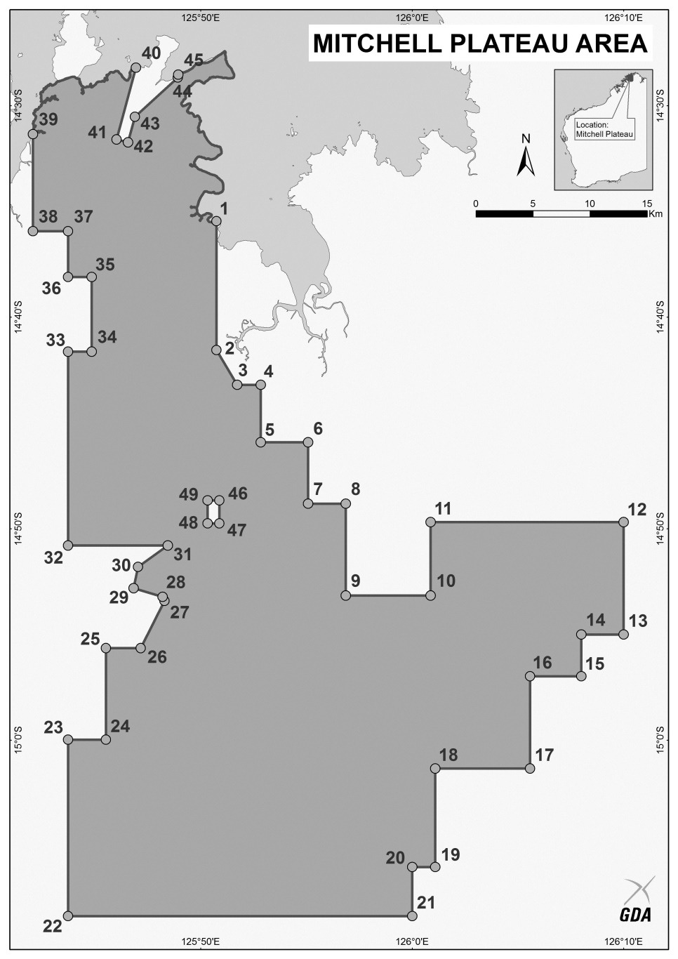
        point means a point on the surface of the Earth identified by a number on the map set out in Division 2.

        (2)         The Mitchell Plateau area is the area of land bounded by —

            (a)         the straight line starting at the intersection of the high water mark and the straight line connecting points 1 and 2, and ending at point 2; and

            (b)         the straight lines connecting points 2 to 38; and

            (c)         the straight line starting at point 38 and ending at the intersection of the high water mark and the straight line connecting points 38 and 39; and

            (d)         the line along the high water mark starting at the intersection of the high water mark and the straight line connecting points 38 and 39 and ending at the intersection of the high water mark and the straight line connecting points 40 and 41; and

            (e)         the straight line starting at the intersection of the high water mark and the straight line connecting points 40 and 41, and ending at point 41; and

            (f)         the straight lines connecting points 41 to 44; and

            (g)         the straight line starting at point 44 and ending at the intersection of the high water mark and the straight line connecting points 44 and 45; and

            (h)         the line along the high water mark starting at the intersection of the high water mark and the straight line connecting points 44 and 45 and ending at the intersection of the high water mark and the straight line connecting points 1 and 2.

        (3)         However, the Mitchell Plateau area does not include the area of land bounded by straight lines connecting points 46, 47, 48 and 49, starting at point 46 and ending at that point.

        (4)         The Mitchell Plateau area is depicted on the map set out in Division 2.

        (5)         The position of a point is to be determined by reference to the coordinates set out in Division 3 opposite the relevant point number.

        (6)         The coordinates referred to in subclause (5) are Geocentric Datum of Australia 1994 coordinates.

        [Division 1 inserted: No. 31 of 2015 s. 7.]

Division 2 — Map

        [Heading inserted: No. 31 of 2015 s. 7.]


        [Division 2 inserted: No. 31 of 2015 s. 7.]

Division 3 — Coordinates

        [Heading inserted: No. 31 of 2015 s. 7.]

Point

Latitude

Longitude

1

14°35'27.24" S

125°50'44.84" E

2

14°41'33.24" S

125°50'44.84” E

3

14°43'11.86" S

125°51'43.34" E

4

14°43'11.86" S

125°52'50.20" E

5

14°45'54.54" S

125°52'50.20" E

6

14°45'54.55" S

125°55'04.55" E

7

14°48'49.00" S

125°55'04.55" E

8

14°48'49.00" S

125°56'51.57" E

9

14°53'09.28" S

125°56'51.58" E

10

14°53'09.28" S

126°00'52.45" E

11

14°49'41.05" S

126°00'52.45" E

12

14°49'41.04" S

126°10'00.00" E

13

14°55'00.00" S

126°10'00.00" E

14

14°55'00.00" S

126°08'00.00" E

15

14°56'58.36" S

126°08'00.00" E

16

14°56'58.38" S

126°05'34.55" E

17

15°01'20.19" S

126°05'34.55" E

18

15°01'20.19" S

126°01'05.17" E

19

15°06'00.00" S

126°01'05.17" E

20

15°06'00.00" S

126°00'00.00" E

21

15°08'19.08" S

126°00'00.00" E

22

15°08'19.09" S

125°43'43.74" E

23

14°59'58.66" S

125°43'43.74" E

24

14°59'58.66" S

125°45'30.86" E

25

14°55'38.38" S

125°45'30.86" E

26

14°55'38.38" S

125°47'09.57" E

27

14°53'24.97" S

125°48'17.01" E

28

14°53'13.00" S

125°48'11.84" E

29

14°52'48.63" S

125°46'49.63" E

30

14°51'48.34" S

125°47'02.22" E

31

14°50'47.19" S

125°48'26.40" E

32

14°50'47.19" S

125°43'43.76" E

33

14°41'37.33" S

125°43'43.75" E

34

14°41'37.33" S

125°44'50.60" E

35

14°38'05.84" S

125°44'50.60" E

36

14°38'05.85" S

125°43'43.77" E

37

14°35'55.70" S

125°43'43.77" E

38

14°35'55.70" S

125°42'03.54" E

39

14°31'20.50" S

125°42'03.53" E

40

14°28'11.87" S

125°46'56.18" E

41

14°31'35.31" S

125°46'01.21" E

42

14°31'43.46" S

125°46'33.54" E

43

14°30'31.09" S

125°46'53.10" E

44

14°28'40.14" S

125°48'55.22" E

45

14°28'31.60" S

125°48'56.22" E

46

14°48'39.88" S

125°50'52.95" E

47

14°49'44.95" S

125°50'52.95" E

48

14°49'44.95" S

125°50'19.50" E

49

14°48'39.88" S

125°50'19.51" E

        [Division 3 inserted: No. 31 of 2015 s. 7.]


AustLII: Copyright Policy | Disclaimers | Privacy Policy | Feedback